Livestream summer solstice at Stonehenge

Stonehenge is closed right now and won’t open until next month, leaving hundreds of disappointed pilgrims and tourists who would otherwise have flocked to the ancient site to see the dawn break over the Heel stone. English Heritage is offering an alternative experience open to everyone in the world: a livestream of sunset today and sunrise tomorrow morning.

The sunset broadcast begins in less than two hours, 8:26 PM GMT (4:26 PM EDT). Sunrise kicks off at a bracing 3:52 AM GMT, which will be shortly before midnight tonight EDT. The video streams will go live a half hour beforehand.

If weather cooperates, and so far it looks good, this is going to be a unique opportunity to view Stonehenge’s interactions with the sun on the longest day of the year because English Heritage will have cameras set up to capture the scene to its best advantage and there will be no people there to get in the way. This is what it looked like last year, just to give you an idea of what a mob scene it usually is:

To join in the remote revelry, simply go to English Heritage’s Facebook page. You don’t need to sign up, sign in or do anything at all other than click and watch. If you’d like to enhance your enjoyment of the moment by learning more about Stonehenge and summer solstice, the excellent weekly English Heritage podcast recently dedicated an episode to it which you can listen to here.

If you aren’t able to view the livestreams, the recorded videos will be posted later on English Heritage’s Facebook page.

And the sunrise (albeit a little short on sun):

Museum acquires Roman lead pig ingot of national importance

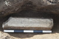
An inscribed Roman lead pig designated of national importance has been acquired by the Wrexham Museum. It was discovered last September by metal detectorist Rob Jones in a field near Rossett, northeastern Wales. He dug up a corner of the object, saw that it had an inscription on it and alerted the local finds liaison officer.

Archaeologists from the Wrexhamn Museum and Clwyd-Powys Archaeological Trust fully excavated the find and surrounding area. The object turned out to be a large lead ingot or pig. It is a rectangle on the long sides with a trapezoid cross-section. At its maximum dimensions, it is 21 inches long, 6.3 inches wide and 4.3 inches high. Some of the lead is missing from one end of it and there are copious cut marks on the surfaces. It weighs 140 pounds.

Lead was mined and processed in several areas of the new province including in north-east Wales where lead processing sites have been excavated near Flint, presumably smelting ores extracted from the nearby Halkyn Mountain. A number of lead ingots of slightly later date are known from these works, often marked with the name of the local pre-Roman tribe called the Deceangli.

Susie White, the local Finds Officer (NE Wales) commented “It has been suggested in the past that similar exploitation took place in the Wrexham area around Minera and particularly Ffrith, where there is a known Roman site, although clear evidence is absent, probably as the result of more recent mining activity.

“We don’t yet know where this ingot has come from and we will probably never know where it was going to. However given the find spots of other ingots from Britain of similar date, it may have been destined for continental Europe, perhaps even Rome itself. The object could tell us a great deal about this important period of our past, a period which is still poorly understood in this area of the country.”

Fewer than a hundred such lead ingots from Roman Britain are known today, and the inscription on this one makes it undisputably one of a kind. It is almost intact, missing only the very beginning which we can interpolate easily from the information in the rest of the inscription. It reads: CAES ^ AVG ^ BR͡IT ^ X ṂAGVL ^ F̣VSVM ^ OP I͡N ^ P͡ROV ^ T͡R͡EB͡E͡L ^ MAXIMO ^ LEG ^ AVG. In full words: [Neronis] Caes(aris) Aug(usti) (plumbum) Brit(annicum) (e)x Magul(…) fusum op(eribus) in prov(incia) Trebel(lio) Maximo leg(ato) Aug(usti). Translation: (Property) of Nero Caesar Augustus, British (lead) from Magul(…), smelted at the works in the province when Trebellius Maximus was imperial legate.

Inscription on Roman lead pig, mid-60s A.D. Photo courtesy the Portable Antiquities Scheme.

Marcus Trebellius Maximus served as governor of Britannia under Nero from 63-69 A.D. In the wake of the Boudiccan revolt of 60/1, Trebellius’ aim was to pacify and stabilize Britain and get to the business of exploiting the province’s rich mineral resources, one of the main motivations for Claudius’ conquest of the island.

He is known from ancient literary sources, primarily Tacitus who mentions him in the Annals, Agricola and the Histories, but very few inscriptions from the empire record his name. This is the only archaeological reference to Marcus Trebellius Maximus ever discovered in Britain.

It is among the earliest dated inscriptions recording Roman seizure of Britain’s mineral wealth and testifies to its rapid exploitation following the spread of Roman power across the island. The production of the ingot presupposes prospection for metals, expropriation of mining sites and the mobilisation of labour, forced or voluntary, to mine and process metal-rich ores. The inscription also illustrates the bureaucratic control exercised over the production of valuable metals.

Hercules Segers motherlode online

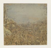
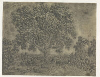
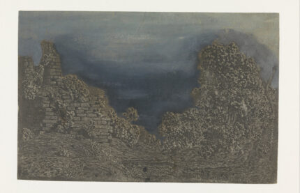
Visionary printmaker of the Dutch Golden Age Hercules Pieterszoon Segers (ca. 1589 – ca. 1638) inspired artists whose names are much more famous than his today, most notably Rembrandt van Rijn who was an avid collector of Segers paintings and prints. Very few Segers works are known to survive today — 183 unique impressions from 53 plates and 18 paintings — and the Rijksmuseum has the largest single collection of them with 74 impressions, two oil sketches and one painting.

Segers’s prints are at the heart of the artist’s later fame. With an array of techniques whose identification has puzzled artists and scholars alike, he etched unusual colourful landscapes, seascapes, biblical scenes and other subjects. Rejecting the idea that prints from a single plate should all look the same, he produced impressions in varied colour schemes, on grounded paper or textiles, colouring his prints with the brush and altering his etching plates by adding lines in drypoint. Employing a variety of unusual techniques and materials, he turned each impression of his etchings into an individual work of art.

The collection formed the core of the landmark Segers retrospective exhibited at the Rijksmuseum in late 2016, early 2017 and subsequently at the Metropolitan Museum of Art in New York City. That exhibition brought together almost all of the extant works known to exist today, including 110 prints and all 18 paintings. In preparing for the retrospective, researchers, scientists and art historians at the Rijksmuseum carried out an unprecedented in-depth study of Segers’ works. The study, which revolutionized understanding of his highly experimental techniques, was published in a new comprehensive oeuvre catalogue in 2017.

The Rijksmuseum has now made much of that information available for free in a new online collection catalogue. All of the museum’s Segers pieces can be viewed in the glorious high resolution to which the Rijksmuseum has made us accustomed with entries summarizing the results of the research and lending new insight into the artist’s process, materials and the dates of his works. The catalogue entries include all known information about the works from measurements to techniques to inscriptions and collectors’ marks usually found on the versos of prints. There are also links to works in the Rijksmuseum, other public collections and private ones that are connected in some way to the Segers prints.

WWII silver cache found in 14th c. castle

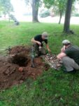
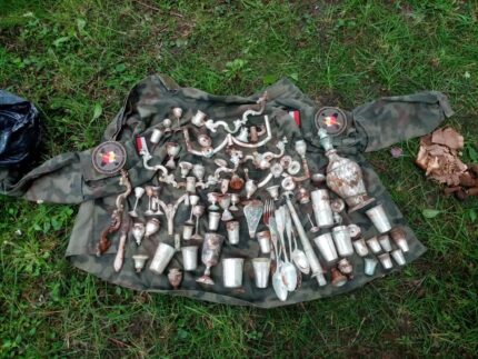
A hoard of silver objects likely buried in World War II has been discovered on the grounds of a 14th century castle in Nowy Sącz, southern Poland. A group from the Nowy Sącz Historical and Exploratory Association were surveying a site near the castle tower when their metal detector alerted them to the presence of what turned out to be a rusted out chest. The crate was corroded almost to nothingness, but the treasure it contained was in excellent condition.

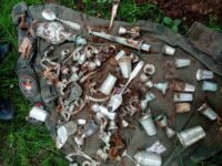
They first unearthed some paperwork — apparently passes and receipts — in poor condition. Under the pages the chest was filled with silver tableware, including goblets, stemware, cups, flatware, serving vessels and candlesticks. In total 103 silver objects were found in the disintegrating chest. The pieces date from the turn of the 19th-20th centuries and the design style identifies them as Jewish ceremonial art.

Local archaeologist Bartłomiej Urbański, who was present at the search site, said: “It is Judaica, probably from the turn of the 19th and 20th century, connected to Jewish ritual and was probably buried during World War Two.

He added: “Is it connected with the buildings that used to be in this part of the city, or was it stolen by the Germans, who were then unable to take it away?”
The town of Nowy Sącz was founded by Wenceslaus II of Bohemia in 1292, eight years before he became King of Poland. Its location near an important trade route to Hungary garnered it significant privileges. Wenceslaus replaced a wooden watchtower perched on a hill within the city’s fortifications with a castle. In the mid-1300s, King Casimir III the Great greatly expanded the royal castle, integrating it into the new defensive wall he had built around the city. This grander castle of Nowy Sącz had two corner towers, at least one other tower, a residential building with multiple stories, and probably a moat separating it from the city proper. For the next 300 years, Polish kings and queens and visiting Hungarian and Danish royalty stayed in the castle. It was devastated by fire twice, once in 1522, once in 1611. After the second fire, the castle was rebuilt and expanded again in Renaissance style by Count Sebastian Lubomirski and, after his death, by his son Stanisław. That phase ended in 1655 when the castle took heavy damage during the Deluge (Sweden’s invasion of the Polish-Lithuanian Commonwealth). It was patched up a couple of times by Austrian authorities after the Partition, but it never really recovered.

It was rebuilt again on a much smaller scale in 1938 just in time for the Nazi invasion of Poland. German forces occupied the castle and used it as a barracks. Under German occupation, 20,000 Nowy Sącz Jews were forced into a ghetto. The ghetto was liquidated in 1942 and all of the town’s Jewish community was sent to slaughter in Bełżec extermination camp. German forces stored large quantities of ammunition at the castle and Polish resistance fighters blew up the depot in 1945, destroying what little was left of the castle. The tower was reconstructed one more time in 1959.

After so beleaguered an existence, only a smattering of walls a few feet high remain of the original 14th century structure. The town of   Nowy Sącz wants to rebuild the castle (yes, again) and convert the tower into a museum. The Sądecki Regional Development Agency contracted with the Nowy Sącz Historical and Exploratory Association to explore the castle ruins assisted by professional archaeologists. They were scanning for shrapnel and metal parts from the explosion when they discovered the silver cache.

The objects will now be transferred to archaeological conservators who will clean, conserve and catalogue them for future display in the local museum.
2000-year-old map carved into volcanic rock

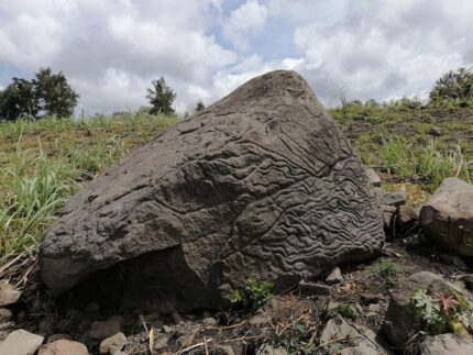
Thousands of years ago, an eruption of the Fuego de Colima volcano hurled a lava bomb nine miles south near the town of Colima, Mexico. The large basalt rock attracted the attention of local inhabitants who carved an elaborate petroglyph on the largest surface which faces the volcano that birthed it.

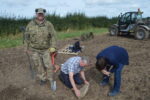
The stone, 5.5 feet high, between seven and nine feet wide and between two and 5.5 feet thick, is currently on private property. The presence of the petroglyph was reported to  the National Institute of Anthropology and History (INAH) who dispatched a team of specialists to register the find on June 7th. They determined that it was a “stone map,” a carved overview of the area with topographical, geographical and population markers.

The identification is based on the designs and patterns and a comparison with other similar petroglyphs found in the region. At least three different techniques were used — polishing, pecking and wearing — to represent different features of the volcano’s landscape. Carved hollows represent populated villages and towns. Lines represent water routes down the mountainside.

Inspection of the map has been conducted by Archaeologist Rafael Platas Ruiz who has found that some features also correspond with the geographical landscape of the southern slope of the Colima volcano, with ravines and rivers clearly apparent.

Rafael Platas Ruiz said: “Without a doubt, these ‘map-stones’ helped to understand and facilitate the management of the land. Furthermore, they were a way of preserving knowledge from one generation to another, at a time when writing did not exist in the territory that is today Colima”.

Archaeologists estimate the carving was done between 200 B.C. and 200 A.D., the Late Preclassic and Early Classic periods, based on the motifs and carving techniques. Ceramic sherds found nearby are much more recent, dating to the  Chanal or Postclassic Colimense phase (1000–1500 A.D.), but they were churned up over centuries of sugarcane cultivation so there is no usable stratigraphic context.