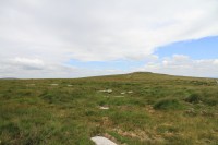
 A previously unknown stone circle has been found on Dartmoor, the first new stone circle discovery in a hundred years. There are 30 stones, all of them now recumbent although packing stones found at the base of some of them indicate they were upright originally, in a circle 32 meters (105 feet) in diameter. One more stone lies just outside the circle and was built into an enclosure wall in more recent history. Radiocarbon dating of the peat underneath the stones found that they fell about 4,000 years ago. That means there’s a chance they could have been erected before Stonehenge which was built between 3,000 and 2,000 B.C.
At 525 meters (1722 feet) above sea level, it is the highest stone circle in southern England and would have dominated the landscape when the stones were still vertical. It is located 300 meters (984 feet) southwest of Sittaford Tor, one of Dartmoor’s hills topped with granite boulders, which was probably the source for the stones in the circle. The fact that the stones are of relatively uniform size and shape suggests they were deliberately selected and carried down the hill to the site.
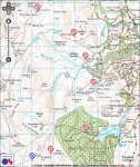
 The location of the circle is particularly significant because it fits perfectly in a crescent pattern created by seven other stone circles on the northeastern edge of Dartmoor. The newly discovered circle is the southernmost of the eight, just west of the first and northernmost circle, the one at Little Hound Tor. The author of the excellent Prehistoric Dartmoor Walks website has created a map of the arc. Archaeologists believe this pattern is deliberate, evidence of large scale planning and communication between the late Stone Age, early Bronze Age communities living on Dartmoor four to five thousand years ago.
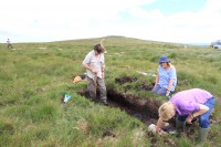
 The circle was discovered by Dartmoor native and stained glass artist Alan Endacott in 2007 after a controlled burn of the undergrowth exposed the stones long hidden beneath the brush. The find was not announced until last year and archaeological explorations are still in the early stages. Since this is the first stone circle found in generations, it gives archaeologists the first chance to study a pristine site using modern technology.
Jane Marchand, Senior Archaeologist, Dartmoor National Park said:
“Its discovery is providing an opportunity for investigation using the very latest archaeological scientific methods to provide long awaited insights into the chronology, construction and the purpose of these most elusive and iconic of Dartmoor’s prehistoric monuments.” […]Although the full results of the geophysical surveys are not back yet, preliminary results have revealed a wide ditch running in a linear fashion just outside the eastern side of the circle. Further investigation is planned later this summer.
The Walks website comments “It is thought that the earliest Mesolithic farmers used slash and burn to create temporary clearings …”.
I doubt that they did; the landscape historian Oliver Rackham was very clear that you can’t clear British broadleaf woodland by slash-and-burn. The ruddy stuff won’t burn. And if you chop down the trees, they don’t die anyway. That’s the whole principle of coppicing, after all. He remarks that nobody has any [plausible, evidence-based] idea how the woodland was cleared.
I’ll bet they used goats to prevent re-growth from stumps, but that leaves me wondering whether they left the landscape littered with tree trunks until they rotted away. Maybe they did. Mind you, guessing isn’t easy if we don’t even know what the original wildwood looked like.
But: the stone circles – the contour map implies to me that they weren’t all visible from their neighbours. I wonder what can be inferred from that?
Very interesting question on how they cleared the landscape. Goats are such geniuses. I watched a half dozen of them completely clear invasive kudzu from a vacant lot in a week. They pulled that stuff down from tall trees and everything.
I think we can infer from the distance between the circles that there the Neolithic/Bronze Age peoples in different areas of Dartmoor interacted with each other over the course of years. That’s assuming the pattern isn’t a huge coincidence, of course, which is probably a valid assumption.
P.S. As you say, that website is excellent.
This is an especially good story, especially since I am (by complete coincidence) rereading The Hound of the Baskervilles for the umpteenth time.
All the talk of moors and tors and crags and stone circles really makes me want to go on a walking tour of England!
Oh yes, I know that feeling well. Between the Brontës, Conan Doyle and Frances Hodgson Burnett, I’ve wanted to wander the moors since I was a kid.
So… stone circle of stone circles? Unfinished stone circle of stone circles? Uncommon shape symbology in the use of a crescent? Either way, highly impressive work of geoglyphy. I wonder if there will be/would have been the entry/exit gaps observed in circle earthworks in other places.
Good questions all. I like the idea of a stone circle of stone circles. DARTMOORCEPTION.
What a wonderful find! Hopefully there’s lots that can be gleaned from its undisturbed context.
One wonders if there are other sites waiting to be found along this arc.
I was wondering the same thing. Time for a much wider geophyiscal survey.
In the MMO Dark Age of Camelot, Dartmoor is where you would go to fight the dragon. I never got to do that.
:skull:
There, there… I’m sure you would have slain given the chance.
XD “Dartmoorception.” Excellent.
In the hope that the distribution of the stone circles is not coincidence (which, as you point out, it rightly could be– but shhhh), they seem to be roughly arrayed round Hangingstone Hill, which makes sense for planning purposes as it’s the highest point in the middle of the present moorland formation. Well, it and Cut Hill, on the flanks of which should logically be one of the next circles in the arc, unless Cut Hill Stream has wiped it away.
There has to be some proper literature on this Hangingstone Hill place…
*Goes to research Hangingstone Hill, which apparently has a cairn, so was obviously significant for someone.* *Gets pulled down the rabbit hole researching why the headwater marsh of so many creeks and streams should sit at such a relatively high altitude in that Cranmere Pool Letterbox swamp thing beside Hangingstone Hill.*
Well, now, http://www.researchgate.net/profile/Stephan_Harrison/publication/258707211_The_glaciation_of_Dartmoor_the_southernmost_independent_Pleistocene_ice_cap_in_the_British_Isles/links/5401f7b50cf2c48563af854d.pdf certainly explains the existence of the relatively high altitude hanging swamp of Cranmere Pool. If their models are correct, it was the convergence/genesis center of a small glacier, and experienced the thickest ice in Dartmoor for a long period of time. That would certainly be either enough to break down the compacted sands, silts, and bedrock of the area, allowing some sort of underground pressurized artesian reservoir to break through in only that area, or enough to cause a major rebound in the landscape when it melted, causing the ground around Cranmere to suck in the meltwater like a dry sponge, leaving it still draining while it collects rainwater from Hangingstone Hill, Black Hill, and Great Kneeset.
Either way, there’s water coming out of the ground at a relatively high altitude, and flowing down to lower elevations. If I were a prehistoric person, that would strike me as quite odd, and possibly important because whoever controls that water (religiously, militarily, politically, etc.) would control the people downstream. So maybe the potential “circle of stone circles” centers on Cranmere Pool instead of on Hangingstone Hill.
…eh. This is all running down rabbit trails without much idea that the rabbit is actually down said trails. But it’s fun to consider.
>_< Looks like comment filter may have eaten my comment on findings concerning how Cranmere Pool formed, and how that might change a hypothesis that the potential "circle of stone circles" were centered upon Hangingstone Hill. Attempting to reconstruct.
The paper by David J.A. Evans, Stephan Harrison, Andreas Vieli, and Ed Anderson entitled "The glaciation of Dartmoor: the southernmost independent Pleistocene ice cap
in the British Isles" (which I hesitate to try linking again, but it appeared in Quaternary Science Reviews and is accessible at ResearchGate, if you are curious) certainly explains the origins of Cranmere Pool. If their models are right, then Cranmere Pool marks the place of convergence/genesis of a small glacier, and experienced a great heavy thickness of ice for a rather long time. That could have two consequences, either of which could have created Cranmere Pool. 1) The continuous weight of the ice was enough to fracture the compacted sands, silts, and bedrock that rests under the peat layer, allowing an underground pressurized reservoir to break through there and only there. 2) The heaviness of the ice so compressed the land that there was a tremendous rebound when the glacier finally melted sufficiently, causing the land to absorb the water like a dry sponge, so that even today it is still draining, while gathering the rain runoff from Hangingstone Hill, Black Hill, and Great Kneeset.
Whatever did happen, there is quite a lot of water pouring out of a high place just there at Cranmere Pool and flowing to lower elevations. If I was a prehistoric person, that would strike me as rather odd, and possibly important, since whoever controlled those waters (militarily, religiously, politically, etc.) would control the people downstream who depend on them. So perhaps the potential "stone circle of stone circles" doesn't center so very much on Hangingstone Hill as it does on Cranmere Pool.
…however, this is all just so much chasing down rabbit trails without any reason to think the rabbit is actually down those trails. Still, it is fun to consider.
Hmm…. It seems I’m in a standing war with your comments apparatus, Livius Drusus. Please forgive.
Or perhaps a bribe of something kinda neat? Someone in Plymouth left online their panel designs for an exhibition of an excavated cist in the Whitehorse Hill area of Dartmoor. If it’s not something you’ve already found, they’re at http://www.plymouth.gov.uk/de/whitehorse_panels_1.pdf and http://www.plymouth.gov.uk/de/whitehorse_panels_2.pdf
Apologies. Slightly embarrassed and hoping not to have annoyed.
Wow. I already thought the post was very interesting but I’m loving the debate and speculation in the comments…
It is hard to tell from that map whether that crescent is a circular arc or an elliptical arc. Any speculation on that?
Mike, agreed, definitely hard to tell.
No idea about official speculation, but I’m most accustomed to seeing circular formations and arcs by the monument builders of the British Isles, when they weren’t doing straights and fields. They’ve done a few known elongated loops with rounded ends, but I’m not familiar with other occurrences of oblate rings…
If it was an elliptical crescent, where would you say the focal nodes are? And where would you say the next stone rings would be, if the crescent continued?
“If it was an elliptical crescent, where would you say the focal nodes are?”
Hard to tell with just that map available. Possibly a foci of an elliptical arc (if it is one) could still be at Hangingstone same as a circular arc. One way forward would be to send a team with GPS to each of the stone circles and then do the math.
“And where would you say the next stone rings would be, if the crescent continued?”
No way to guess without better data.
Let’s try to pull some more data out of that map, then. It may be a little imprecise, but it can still tell us things.
Elevation of the stone circles does not seem to be a factor, because they range everywhere from close to elevation 500 down to just under elevation 400, though three or more seem to cluster within 20 of elevation 400.
Looking at the slope of the land, most of the stone circles likely could have been seen from the top of Hangingstone Hill, though the ones least likely to be able to be seen (Buttern Hill stone circle, Scorhill Circle, and the new stone circle) appear to have a cairn almost in line between them and Hangingstone Hill. The map doesn’t indicate whether all monuments are contemporary or not, but if they are, this could be a clue.
With the exceptions of the stone circle in Fernworthy Forest and the new stone circle, the builders seem to have preferentially built on sturdy foundations occurring near water features (swamps or creeks). Then again, it’s rather hard to get away from said water features in Dartmoor, so this is likely to be coincidence.
Where the builders HAVEN’T built is even more interesting: they seem to almost emphatically refuse to place the stone circles on the tors themselves. It would make sense from a standpoint of convenience and visibility to put the stone circles at the tops of hills where exposed rock already exists, but they didn’t. So we can probably rule out stony hilltops as locations of other lost stone circles.
Even with a wider map, I can’t draw any relationship between the stone circles and the stone rows… maybe there’s something there that’s too obscure for my eyes, or maybe they are unrelated. Does anyone else see anything?
Hmm. That’s about all I can pull out at a glance. But it slightly narrows down possible other locations. 😀