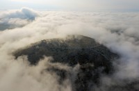
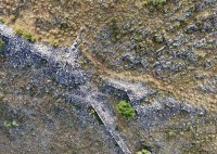
 A team of archaeologists from the University of Gothenburg and University of Bournemouth has discovered the ruins of a previously unknown ancient city near the village of Vlochós, about 200 miles north of Athens. A smattering of ancient remains were known to be on Strongilovoúni hill on the plains of Western Thessaly, but they were believed to belong to a small rural settlement. Fortifications, more than eight feet high in some places, are visible on the hill, as are the remains of towers and city gates. The new discoveries lower on the hill were obscured by layers of silt and sediment deposited by the river Enipeas.
This year archaeologists launched the first major systematic exploration of the hill, which has also been virtually ignored by scholarly research other than a few tangential descriptions of the archaeological remains. The Vlochós Archaeological Project (VLAP) is remedying this oversight starting with a non-invasive investigation of the site using technology like Network Real Time Kinematic GPS for precise measurements, drone photogrammetry and ground-penetrating radar.
During a mere two weeks in September, the VLAP team discovered that this supposedly sleepy backwater was actually a thriving polis.
“We found a town square and a street grid that indicate that we are dealing with quite a large city. The area inside the city wall measures over 40 hectares. We also found ancient pottery and coins that can help to date the city. Our oldest finds are from around 500 BC, but the city seems to have flourished mainly from the fourth to the third century BC before it was abandoned for some reason, maybe in connection with the Roman conquest of the area.”
[University of Gothenburg PhD student and fieldwork leader Robin] Rönnlund believes that the Swedish-Greek project can provide important clues as to what happened during this violent period in Greek history.
“Very little is known about ancient cities in the region, and many researchers have previously believed that western Thessaly was somewhat of a backwater during Antiquity. Our project therefore fills an important gap in the knowledge about the area and shows that a lot remains to be discovered in the Greek soil.”
 The fortifications on the hill were built in the late Archaic to the Hellenistic periods (ca. 500-200 B.C.), but there is evidence of repairs done in the Late Roman/Early Byzantine eras, so if it was entirely abandoned for a stretch after the Roman conquest, it was reoccupied, or at least strengthened by the end of the Roman period.
The exploration of the site will continue next August during the second season of the project. Archaeologists hope a thorough ground-penetrating radar study will answer some of the questions about the development of the city.
Here is some picturesque drone footage of the remains on the hill taken from 1500 feet above ground level.
[youtube=https://youtu.be/wWjY-4e-CRg&w=430]
This is exciting! Another lost city. Not every day you hear news like this one. Hopefully, they accept volunteers archaeologists 🙂
Ok, I found ‘Vlochós’, but where the heck is ‘concentrated on and immediately below Strongilovoúni, an isolated hill towering 215 m’ ? ..Ah, to the West, there is a ‘Σωτήρας-Κάστρο Τιτανίου’ (Titans 😀 ?), but ours seems to be the ‘Κάστρο’ right to the the South of Βλοχός.
You can indeed clearly see the castle on the satellite images – I had originally started with Openstreetmap: Μαραθέα – Βλοχός, Δήμος Παλαμά (‘Vlochós in the municipality of Palamás’), Karditsa Regional Unit, – 22° 05′ 22,8″E, 39° 31′ 16,3″N
:hattip:
A perfect dream site to dig, no later occupation, and unobstructed views of the countryside. Wow.
Exciting find. Where is the nearest source of fresh water for such a large, hill-top, site?
If it’s the same spot Elmar found, there’s a river running right by the foot of the hill.
See if this link works:
https://www.google.ca/maps/place/39%C2%B031'00.0%22N+22%C2%B005'00.0%22E/@39.5090513,22.0839253,1920m/data=!3m1!1e3!4m5!3m4!1s0x0:0x0!8m2!3d39.5166667!4d22.0833333
Can we call this abandoned city Vlapopolis?
:chicken:
So, who would be sent to bring up the water? Wives, children, servants. Not the man of the house!
“Vlapopolis I – IV” :giggle: – No later occupation ? Maybe – “Troy” for example, as an extreme case, turned out to be SEVEN(!) cities on top of each other. Usually, there is a ‘Polis’ and an ‘Akropolis’, meaning a city and some sort of ‘fort’ further atop (‘ἀκρο’).
“Troy” with the seven layers was seemingly the “Trojan” Akropolis. The coordinates for our city, and the ones for the ‘Titanic’ Κάστρο, are 22.0878184 E, 39.5091417 N and 22.0317567 E, 39.5150735 N – Of course, the the man of the house had sanitary engineering and slaves.
I’ve been visiting your blog on and off. I’m currently minoring in anthropology/archaeology, and subsequently any new news is relevant to me, especially cities found in Greece.
The water for livestock and crops likely came from the river. For a hilltop city or a town, cisterns and reliable springs are more likely. For springs, it depends on the underlying rock layers. The place seems simply too big to have been a temporary safe haven or stronghold with the population mainly living in the valley below.
In the rainy periods a rocky hill like that would be full of wet springs on the slopes. If the rock layers are right, a few perennial springs would likely be available year round on low spots in the slopes and heads of hollows for drinking water. The founders wouldn’t have put a permanent town on a hill if there was no reliable source of water on it.
Overgrazing and harvesting of firewood on the slopes may have altered the ability of the aquifers in and underlying the hill to absorb and hold water, making it unable to support such a large site for more than a couple of centuries.
Want to be farmers still get stuck with property on dry ridges from canny locals to this day. Walk your dream farm on the hill during a dry spell before you shell out the cash for it.
Carrying water and feed a half mile up a steep hill grows old very fast, I’ve done it. Farmers in antiquity would have told the local bully boy to stuff it if they had to depend on the river for all their needs in that city on the hill.
Very interesting.While looking at this site on Google Earth there seems to be another city S.E. of the village of Piniada in the same hilly area. It is the hill that is closest to the river and has a strange red tint on top. 39 34 16.05N 22 11 30.46E Sites all over this world waiting to be found.Many time the locals know about them and think they are just some old rocks.