 The Fossa Carolina (Karlsgraben in modern German) is named after Charlemagne, King of the Franks, future Emperor of the Romans, who according to contemporary Carolingian sources commissioned its construction in 793. About two kilometers (1.2 miles) long, the canal was meant to link the Swabian Rezat river in Treuchtlingen to the Altmühl river in Weissenburg, Bavaria. The Rezat is in the Rhine basin and the Altmühl is a tributary of the Danube, so the ultimate idea behind the canal was creating a navigable water route that would allow easy boat travel between the Rhine and the Danube.
Whether it was a practicable solution in real life was a whole other ball of wax. According to the Revised Royal Frankish Annals, Charlemagne was “persuaded by self-styled experts that one could travel most conveniently from the Danube into the Rhine if a navigable canal was built between the rivers Rezat and Altmühl.” Reliable canal-linked fluvial transport was immensely important to Charlemagne in 793. He had been forced to end his 791 campaign against the Avars south of the Danube when his cavalry was stricken by the Eastern equine encephalitis (EEE) virus. The deadly mosquito-borne illness killed 90% of Charlemagne’s horses and other equines — war steeds, travel mounts, pack animals — in a matter of days. The few equines that survived a bout of EEE would have been severely disabled, suffering from brain damage and neurological symptoms that made it impossible for them to perform their usual duties of combat and transportation.
This was a logistical headache of brain-shattering proportions. Without horses and mules, the army’s supplies, weapons, armour and assorted gear had to be carried by people, at least some of it by horseless cavalrymen, to the Danube where it was loaded on boats. Charlemagne’s forces were so hobbled by the mass death of its equines that he wasn’t able to go on campaign for two years, and Charlemagne fought every year of his kingship, missing only four in total.
If the canal worked as planned, fluvial transportation — faster, cheaper and not subject to epidemics — would make it possible for Charlemagne to get back to his military campaigns against the Avars and rebellious Saxons, a war on two fronts that would have been enormously facilitated by a canal linking the Rhine and Danube. He would have been able to use large boats, not pack animals, to move equipment and supplies down the Danube in a new campaign against the Avars the next year. In addition, the actual digging of the canal required few horses, a big plus in a time of such equine scarcity.
It was such an important project that Charlemagne took up residence in Weissenburg in the fall of 793 to oversee construction of the canal. He personally saw to the hiring of a large team of builders. Under his direct supervision, the crew dug a moat 2,000 feet long and 300 feet wide. Again according to the Annals, canal constructed ended abortively, defeated by the marshy ground and constant rainfall which caused “what the workmen dug during the day, fell back in at night.” Other chroniclers claim the canal was in fact completed. Either way, Charlemagne’s attention was diverted to more pressing matters: fresh revolts in Saxony and attacks on Narbonne and Carcassonne by Umayyad Emir Hisham I of Córdoba.
 Today there is little left of the most important infrastructure projects of the Middle Ages. There’s a water-filled moat about 350 meters (1148 feet) long in Treuchtlingen. Earthen embankments almost 4,000 feet long and more than 30 feet high also survive, created by the soil dug out of ground during the early construction of the canal. Over the past five years or so, archaeologists have discovered the northernmost section of the structure which is not visible above ground.
 That section, which was fortunate enough to be forgotten and/or ignored for 1,200 years, has proven archaeologically invaluable. A team of researchers from German universities and the Bavarian State Office for the Protection of Monuments have discovered that the canal is older than the Royal Annals recorded. The question of when construction of the Fossa Carolina began has been a fraught one among historians for a century. The Alemannic Annals claim that canal construction began in 792, which would mean that Charlemagne’s stay in Weissenburg was a visit to an ongoing building site, not a new one he was personally supervising.
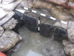
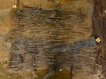
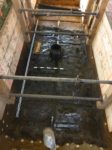
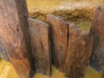
 In 2013, timber pilings were discovered in the northernmost section that were dendrochronologically dated to the late summer or early fall of 793. A follow-up excavation in 2016 went even further, digging two trenches across two of the northern canal sections. The team unearthed numerous structural elements, including large oak pilings lining the canal walls that were in an excellent state of preservation thanks to the high groundwater level and a deposit of sediments immediately after construction.
 The team was able to date more than two dozen timbers using dendrochronological analysis, an incredible bounty for high precision absolute dating. Tree ring analysis can pinpoint dates down to the year, sometimes even the month, and the youngest of the canal timbers tested date to the late spring or early summer (probably May) of 793. This was freshly cut wood. It hadn’t been stored for a few months before use in the canal.
This shows that the construction work at the Karlsgraben started several months earlier than was previously known. The description in the sources that the command for the construction of the canal has already taken place in 792 is thus significantly more likely. For the first time, the historical and political framework conditions of the decision to build the canal can now be clarified. The new dating also shows that Charlemagne visited a construction site, which had already begun several months earlier in the late summer/autumn of 793, and was by no means the “first spade”. […]
In the coming months, the new dates will be analyzed in detail and combined with numerous other results from the interdisciplinary research group. Due to the precise and different dates the researchers expect for the first time indications for the construction direction of individual channel sections and organizational details of the large construction site. New results are also to be expected regarding the completion or non-completion of individual construction sections.
To further illustrate this, there is a map of the ‘European water divide’, …
i.e. where the water will either end up in the North Sea via the Rhine or in the Black Sea via the Danube, and where the 8th century ‘Fossa Carolina’, and the more modern (and even recent) artificial waterways are to be found.
Besides, he did apparently did (kind of) manage successfully to travel from Regensburg via the Rezat to Würzburg by boat 😉
———————-
[ANNALES REGNI FRANCORUM, entry for 793 AD] DCCXCIII. Rex [Charlemagne] autumnali tempore de Reganesburg [Regensburg] iter navigio faciens usque ad fossatum magnum inter Alcmana [River Altmühl] et Radantia [River Rezat] pervenit, ibique missi apostolici cum magnis muneribus praesentati sunt. Ibi missus nuntiavit Saxones iterum fidem suam fefellisse. Inde per Radantia in Mohin navali iter peragens, natalem Domini celebravit ad sanctum Chilianum in Wirzinburg [Würzburg].
:hattip:
I love the idea that we can still nail down details of history over a thousand years later! :love:
Any particular reason why comments were blocked on the soldier quilt post? Not that I had anything to contribute to it, I’d just have wondered how on earth you finance your bandwidth with such huge images.
What will future archaeologists make of the abandoned high speed railway line between LA and SF? It will be abandoned, won’t it?
The canal sheds an interesting light on how backward Western Europe had become. In Roman times you could take a boat from Cambridge to York without going to sea, just by using canals/drains/rivers.
Talking of transport and the Romans
http://www.dailymail.co.uk/sciencetech/article-4725854/Britain-s-network-Roman-roads-reinvented-subway-map.html
Keep in mind that the canal area in question had in fact been Roman (cf. ‘Ala I Hispanorum Auriana’ in Castra Birciana).
However, there was no Roman canal. Instead, there was a ‘Limes wall‘ to be kept under control, which by 254 AD was no longer successful.
Charlemagne was Roman Emperor in less than a decade after his visit of 793AD, and the next canal was built yet another millennium afterwards. Ok, after 1806, of course, the “Imperium” was no longer “Roman” :facepalm:
Dearie, I was once in York in late July and nearly froze as the region apparently doesn’t have summer. Why would anyone want to make it easier to get to the Murmansk of England?
The “Novo-Yorviksibirsk of England” ?!? – To my regret, I never made it up there, not even by boat 🙁
No, no, it was to make it easier for people to head south FROM York.
From the links given above: Central European watershed and the ‘Fossa’/ ‘Graben’ and Frankish-German harbours (500-1250 AD), plus the ‘Fossa’ on GMaps.
———–
“Inde per Radantia in Mohin navali iter peragens, natalem Domini celebravit ad sanctum Chilianum in Wirzinburg” – “Then, making his waterway from the Rezat to the Main river, he celebrated Christmas [793] in St. Kilian [Cathedral] in Würzburg”.
———–
Next to the ‘Fossa’, there is what is referred to as “witches gathering”, and yet another ancient fortification at 10° 57′ 13,2″E, 48° 59′ 23,3″N (‘Sternschanze’).
Thanks Ealdberth!