 The remains of a Viking ring fortress discovered on the Vallø Estate on the Danish island of Zealand have been radiocarbon dated and the results confirm the tested area was built in the 10th century. Two samples of charred wood from the northern gate of the structure were tested and produced identical dates: between 895 and 1017 A.D. The samples were taken from the outermost tree rings of the logs and tested at the Department of Physics and Astronomy of Aarhus University in collaboration with Accium BioSciences’ laboratories in Seattle.
 The archaeologists from the Danish Castle Centre and Aarhus University who made the find were convinced they had uncovered the first Trelleborg-type fortress in more than 60 years. Only seven of these ringforts built by King Harald Bluetooth in around 980 A.D. probably as part of a defensive network against the Germans have been found in Denmark and southern Sweden. The discovery of a new one was big news, therefore, but since only excavated small sections of the gates and ramparts had actually been unearthed, some archaeologists felt they were jumping the gun in labeling the find a Viking ring fortress.
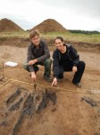
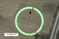
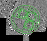
 The excavation wasn’t all they had to go on. The team had done extensive research on the site, performing a detailed laser survey followed by a geomagnetic survey that revealed a structure 475 feet in diameter underneath a mound barely visible to the naked eye. Like the other Trelleborg fortresses, this structure too appeared to be perfectly circular with four gates at the cardinal points of the compass. Armed with the survey data, the team excavated two areas likely to be gates. At the north gate, the team found the large burned oak timbers that were radiocarbon dated.
The oak logs aren’t done testifying to their age. Carbon-14 dating by its nature can’t be narrowed down any further, but tree rings can dated to the individual year. Dendrochronological analysis may give us a precise date. If it’s 980 A.D. or thereabouts, that will be powerful evidence that it’s one of Harald Bluetooth’s Trelleborg fortresses.
 The sheer amount of effort required to build this fort, dubbed Borgring, suggests it was meant to convey power. Archaeologists found there was a basin of fresh or brackish water next to one of the walls, an inlet between Køge Bay and the ring fortress. The builders must have had to dig out hundreds of tons of clay from the subsoil into the inlet in order to support the fort. If they had built it a little further inland, none of that extra work would have been necessary. According to Nanna Holm, curator of the Danish Castle Centre, the location was chosen deliberately to signal the power of its owner.
The excavation has also shown that the construction of the fortress is closely related to other Viking fortresses such as Fyrkat near Hobro, Aggersborg near the Limfjord and Trelleborg near Slagelse. These fortresses were undoubtedly built during the reign of Harald Bluetooth, and still more evidence suggests that Borgring, as the fortress has been named, might have belonged to the same building programme.
“There are a lot of similar details in these structures. And it’s been wonderful to see the same things coming to light at Borgring. In addition to the structure of the rampart and the gates, we have also found traces of a street with wood paving running along the inside of the rampart – just like in Fyrkat, Aggersborg and Trelleborg. The most striking thing, however, is the measurements of the fortress. The rampart of Borgring is 10.6 metres wide. That is exactly the same width as the rampart of Fyrkat. So it’s hard to avoid the sense that the same master builder was responsible,” says [Aarhus University medieval archaeology professor Søren] Sindbæk.
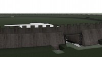
Here’s a 3D reconstruction of Borgring based on the excavation with some hypothetical extrapolation: