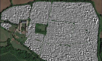
 For the first time, archaeologists have mapped a complete Roman town using ground-penetrating radar. Archaeologists from the University of Cambridge and University of Ghent were able to cover all 30.5 hectares of the site of Falerii Novi, a Republican-era town about 30 miles north of Rome, using the latest GPR technology which allowed to scan large areas more quickly and in higher resolution than ever before. The technology makes it possible for archaeologists to see the city at different depths without disturbing any of it, giving them the opportunity to study its evolution from foundation to demise.
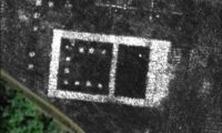
 The scans have revealed the foundations of public bathhouse, a market building, houses, a theater, shops, multiple temples and a large monumental building of an unknown type that may be related to the religion of its Italic residents, the Falisci. It is located near the north gate. It consists of two large structures about 200 feet long with a central row of columns. It contains two smaller buildings with niches, likely for statues. Archaeologists have never seen anything like it before.
The GPR also revealed water pipes connected to a rectangular structure — believed to be an open-air pool — in the southern district of the city. From that starting point, archaeologists were able to map the water pipe network of the entire town. They run underneath the buildings, not along the streets as usual. This means the city was planned to the point that the water conduits were installed before the buildings went up. That is not something you see a lot in the third century B.C. when Falerii Novi was built.
The Falisci were an Italic people in what is today the region of Lazio, then under the Etruscan sphere of influence. Fearing with very good reason the steady rise in power of the city on the Tiber just 30 miles away, the Falisci allied with Etruscan cities in their wars with Rome in the 5th century B.C. They continued to send military aid to Etruscan cities in their uprisings against Rome in the 4th century B.C. and were soundly defeated, but it took a concerted Roman campaign of battle and crop destruction against Tarquinia and its Falisican allies to induce the Falisci to sign a long-term truce in 351 B.C.. Just to keep an eye on these unruly neighbors, Rome established a garrison in the Falisican capital Falerii Veteres.
It lasted a surprisingly long time, given the history of hostility between the parties, but the Falisci took up arms with their old comrades the Etruscans in 293 B.C. Come the First Punic War (264-241 B.C.), the Falisci made a break for it, declaring themselves independent of Rome. Rome disagreed, and this time they took no half-measures. The victorious Romans took all of the Falisci’s weapons, horses, slaves and half of their territory. Falerii itself was raised. The survivors were moved to a new city (hence the name Falerii Novi) three miles northwest, which at its peak in the last centuries of the Republic had a population of 2,500.
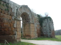
 Unlike their original hometown which was perched on a plateau and surrounded by deep gorges, the new site was exposed with no natural defenses. The Romans built a strong defensive wall with more than a mile long encircling the new city. Large portions of it survive in excellent condition with 50 of the original 80 towers still standing and two of its original eight gates.
The town was abandoned around 700 A.D. and was left to ruin. Very few visible remains of the town inside the walls survive, mostly from the theater and forum which were excavated in the 19th century. It was never built over, which made it a perfect candidate for GPR scanning.
“If you’re interested in the Roman empire, cities are absolutely critical because that is how the Roman empire worked – it ran everything through local cities,” said Martin Millett, a professor of classical archaeology at the University of Cambridge.
“Most of what we’ve got, apart from in sites like Pompeii, are little bits. You can dig a trench and get little insights, but it’s very difficult to see how they work as a whole. What remote sensing does is enable us to look at very large, complete sites, and to see in detail the structure of those cities without digging a hole.”
