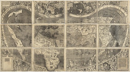
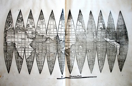
Researchers at the Munich University Library have discovered a rare, probably unique, 1507 print of a world map by German cartographer and monk Martin Waldseemüller that includes the newly christened continent of “America.”
In the spring of 1507, Waldseemüller designed the first map of the world that included a continent he named “America” after explorer Amerigo Vespucci who was the first to recognize that the lands Columbus had stumbled on were not part of Asia, but rather a new continent altogether. Using information gathered by Vespucci in his 1501-1502 expedition to the New World, Waldseemüller created the first map to depict a separate Western Hemisphere and a separate Pacific ocean. He printed an edition of 1,000 copies of that first map, made out of 12 large woodcut prints that put together compose a huge 32 square feet wall map. Nicknamed “America’s Birth Certificate,” there is only one copy of it known to survive.
For hundreds of years it was hidden in Schloss Wolfegg, the Renaissance castle of the House of Waldburg-Wolfegg. It was rediscovered there in 1901 to much excitement worldwide, including from the United States which offered to buy it regularly for a century. Finally in 2001 the Library of Congress purchased it from Prince Johannes Waldburg-Wolfegg for $10 million. Since it’s such a rare and important part of Germany’s cultural patrimony, the German government had to agree to let it go, which they did after a review as required by law. It took the LoC another two years to raise the money from public and private sources. In 2003, the map went on temporary display and in 2007, 500 years after Waldseemüller created it, America’s Birth Certificate was officially transferred to the American People by German Chancellor Angela Merkel in a ceremony at the Library of Congress.

The map found in Munich was a smaller version made by Waldseemüller after he’d completed the wall map. It depicts the same revolutionary vision of the world, but on a much smaller scale. The world is divided into 12 tapered segments, globe gores that were intended to be cut out and glued onto a sphere three inches in diameter to make a small globe. That makes it the first globular map to include a continent named “America” separated from Eurasia by the Pacific Ocean.
Only four other copies of Waldseemüller’s segmented globe map are known. There’s one in Minneapolis, one in Offenburg and one in another Munich library, the Bavarian State Library. The fourth was purchased by a private collector at auction in 2005 for a cool $1 million. The University Library’s version is different in key ways from the other four. The top halves of the segments are not as crisply incised, and the lettering and hatching lines are also different. The city of Calicut (today Kozhikode) on the southwestern Malabar Coast of India is placed on the fourth segment in this map; it’s on the fifth segment in the others.
The map was discovered during a catalog revision wedged between two early 16th century geometry prints that had been rebound together in the 19th century. Researchers don’t know if Waldseemüller’s map and the geometry subjects were connected in some way other than being from the same period, but it’s certain that the 19th century librarians did not realize what a rare gem they had since they didn’t document it or highlight it.
But it survived the Second World War unscathed, although the University Library itself was devastated by air raids. In November 1942, large portions of the holdings of older books, including the unassuming volume containing the two geometry treatises, had been transferred to a safer rural location. Stefan Kuttner [, Curator of the Library’s Department of Early Printed Books,] has ascertained that the book was among the contents of deposit box No. 340, which was first stowed away in Burghausen, and later transported to Niederviehbach near Landshut. The box was returned to Munich in 1955, and provisionally stored in the Northeastern Repository at LMU.

What has been referred to as the ‘birth certificate’ seems in fact to consist of a trinity: The map, the globe (map) of which a copy has been found and his written accounts.
“Universalis cosmographia secundum Ptholomaei traditionem et Americi Vespucii aliorumque lustrationes” … yes, “aliorumque lustrationes” is remarkably not exactly precise.
Also, I was not aware that it had been stored in Bamberg, cf. http://en.wikipedia.org/wiki/Johannes_Schoner
:hattip:
:boogie:
I love Google Maps. It not only helps me get where I want to go, but I’ve spent many hours looking back at my own history. My first home is now just a barren field. I still look around and remember all the places I’d been, wandering around with friends and the adventures we had.
I really love regular paper maps. Look how far it is from here to there! Oh, hey, they were talking about this place on the news or in National Geographic! That’s where that place is! Ha ha! Look at the name of this place here!
If I papered my walls with maps, it might be ugly, but damn if I’d always dream of the places I could go.
Looks more like the birth certificate of South America. Where’s the birth certificate North America? What are you hiding?
Why would you think they are hiding something? This was the information known at the time. Vespucci knew North America existed, but it had not been sufficiently charted at that time. It wasn’t until 1538 that North America was represented with South America in Mercator’s map of the world.