The UK’s National Archives has compiled an astonishing interactive map detailing the locations and dates of all the bombs that fell on London and environs during the Blitz. The Bomb Sight project has taken the original bomb census maps which documented the Blitz as it happened between October 7th, 1940, and June 6th, 1941, and uploaded the data onto web map. The bomb census maps used to only be available to visitors who went in person to the Reading Room of The National Archive, so this is an incredible resource now at the public’s fingertips for the first time.
You can type in a zip code to pull up a map of all the bombs in the area, or you can just browse the maps by zooming in and out as you please. You can click on each bomb for details, then click a “read more” link to see period photographs from the Imperial War Museum and the BBC’s People’s War archive of the devastated area. They’ve also collected memories of the bombings from people who lived in the area, so when you zoom in on one bomb you can read first person accounts of the experience from survivors. The sheer density of information is mind-boggling.
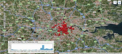
The website is having timeout errors right now because it’s so amazing, but don’t give up. You get a whole new understanding of the Blitz by seeing it mapped out. Here are the bombs that fell on London on September 7th, 1940, the first night of bombing:

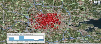
Here are the bombs that fell on London during the second week of October:

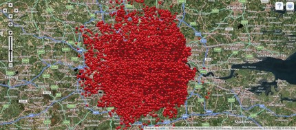
Here are the total bombs that fell on London at night from October 1940 to June 1941:

In. Sane. It’s hard to believe a city could survive that with any structures left standing at all. The statistics — 20,000 civilians dead, a million plus homes destroyed, 57 consecutive nights of bombing — as horrific as they are can’t convey the scale of destruction. An interactive map is worth a million stats, to coin a new cliche.
Bomb Sight is also working on an Android App with Augmented Reality, which uses GPS data so people walking around in London can find out if a bomb hit anywhere near them. People not in London will also be able to explore the city with this app.
I always thought it was crazy that Brits shipped their children off to live with complete strangers in the country during the Blitz. In light of this map, perhaps that was not so crazy.
Definitely not. When you see it laid out like this, it’s clear that there was just no safe place in the city.
There is still a London because cities don’t just go away. Cities aren’t just structures that can be destroyed. Cities are also people who are drawn to it, and who decided to settle there in the first place as much as they decide to rebuilt structures when they’re destroyed. There is still a Coventry. There is still an Ypres. There is still a Hamburg, a Berlin, a Cologne, a Munich, too. Or a Dresden, or just about any(!) German city, most of which have been thoroughly bombed pretty much to the ground. There is still a Tokyo, a Hiroshima and a Nagasaki. I could go on.
Well yes, many cities do survive destruction (although not all). The question was rhetorical, asked to underscore the shocking visuals of the Bomb Sight map.
The visuals would probably even more shocking, if they would reveal the not (yet) detonated ones …
Coincidental detonations after 1999
And yet there is no Carthage or Herculaneum… so cities can be destroyed completely. Hard to do, but not impossible.
Shades of” Gravity’s Rainbow”.
Sure there’s a Herculaneum. It’s called Ercolano.
Granted, it’s a few meters top of the the Roman city, but it is definitely a thriving city. (Indeed, if it were not such a thriving city, archeologists would have a much easier time getting on with excavating the Roman city.)