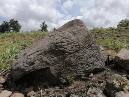
Thousands of years ago, an eruption of the Fuego de Colima volcano hurled a lava bomb nine miles south near the town of Colima, Mexico. The large basalt rock attracted the attention of local inhabitants who carved an elaborate petroglyph on the largest surface which faces the volcano that birthed it.
The stone, 5.5 feet high, between seven and nine feet wide and between two and 5.5 feet thick, is currently on private property. The presence of the petroglyph was reported to the National Institute of Anthropology and History (INAH) who dispatched a team of specialists to register the find on June 7th. They determined that it was a “stone map,” a carved overview of the area with topographical, geographical and population markers.
The identification is based on the designs and patterns and a comparison with other similar petroglyphs found in the region. At least three different techniques were used — polishing, pecking and wearing — to represent different features of the volcano’s landscape. Carved hollows represent populated villages and towns. Lines represent water routes down the mountainside.
Inspection of the map has been conducted by Archaeologist Rafael Platas Ruiz who has found that some features also correspond with the geographical landscape of the southern slope of the Colima volcano, with ravines and rivers clearly apparent.
Rafael Platas Ruiz said: “Without a doubt, these ‘map-stones’ helped to understand and facilitate the management of the land. Furthermore, they were a way of preserving knowledge from one generation to another, at a time when writing did not exist in the territory that is today Colima”.
Archaeologists estimate the carving was done between 200 B.C. and 200 A.D., the Late Preclassic and Early Classic periods, based on the motifs and carving techniques. Ceramic sherds found nearby are much more recent, dating to the Chanal or Postclassic Colimense phase (1000–1500 A.D.), but they were churned up over centuries of sugarcane cultivation so there is no usable stratigraphic context.

While it does look a lot like an eagle-head, and you can clearly see where it is marked “YOU WERE HERE”, a reference to the lucky observer of the eruption, one question remains: “How did they get it into the glove-compartment?”
Big gloves, Jim, big gloves.
“Carved hollows represent populated villages and towns” — I’m curious if they might be able to use that map to find some traces of them.
Last year, I visited La Campana an archaeological site near the city of Colima. Our guide pointed out petroglyphs laying in all sorts of positions around the site. There were also shards of pottery on the ground everywhere. They estimate only 1% of the site has been explored. I wonder how many of these are yet to be discovered.