Kitchen reno in York rediscovers 17th c. frescoes

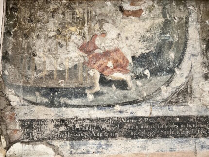
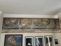
A group of 17th century wall paintings have been discovered during renovations of a flat in Mickelgate, York. A section of painted plaster was first discovered behind a kitchen cabinet by refitters working on the apartment of Dr. Luke Budworth. He later found a larger section boarded up high on the wall below the ceiling.

The paintings are believed to date to the 1660s. They are scenes from a book that was popular at that time, Emblems by poet Francis Quarles, first published in 1635. An emblem book was a collection of allegorical or symbolic images illustrating epigrams, poems and/or commentary. Quarles took the form in a new direction with his Emblems, paraphrasing the Bible in the complex figurative language of the metaphysical poets and adding a verse epigram at the end. Each Emblem was accompanied by an illustration in the grotesque style (meaning cherubs and florals and filigrees inspired by the frescoes of the Domus Aurea, not in the modern sense of “grotesque”) by engraver William Marshall.

(Fun fact: Quarles had 18 children with his wife Ursula. Among his many, MANY direct descendants were several poets, including the African-American luminary of the Harlem Renaissance, Langston Hughes.)

Damage to the wall paintings makes them difficult to identify, but one of the scenes of the ceiling frieze is the Marshall illustration of Book V, Emblem X. An angel is picking the lock of a cage holding a man captive. It’s a representation of Psalm 142.7 “Lord, free my Captive Soul; and then thy Praise/Shall fill the remnant of my joyful Days.” Under the painting of the angel freeing the captive soul is the epigram that concludes that emblem, painting in white text over a black background:

Paul’s midnight voice prevail’d; his music’s thunder
Unhinge’d the prison-doors, split bolts in sunder :
And sitt’st thou here, and hang’st the feeble wing?
And whine’st to be enlarged? Soul, learn to sing.

Simon Taylor, Historic England’s senior architectural investigator for the north region, said it was an “exciting rediscovery”.

“We think they are of national significance and in the context of York, where domestic wall paintings are quite rare, they are of special interest,” he said.

The wall the scenes are painted on could be older than the buildings on either side of it, he said.

The paintings are also cut off by the ceiling and the front of the building, which could help researchers piece together the development of the street.

Luke can’t afford the expense of full conservation out of his own pocket, but he’s seeking funding for the project. For now, he has covered up the frieze with a high resolution printout of pictures of the paintings to protect them from the sun.

Hoard of 17th c. Lithuanian coins found in Poland

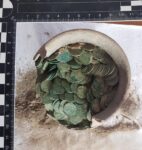
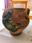
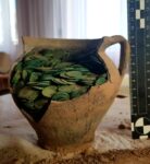
A hoard of 17th century Lithuanian coins has been discovered on the outskirts of Zaniówka, Poland. The initial find was made by Michał Łotys who, in a twist from the usual way these things go, was scanning a field with a metal detector looking for lost parts of mechanical agricultural equipment. Instead he found some loose coins and a ceramic jug tightly packed with more coins.

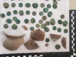
Unlicensed metal detecting for archaeological artifacts is against the law in Poland, so as soon as he realized what he’d found, Łotys alerted the Provincial Office for the Protection of Monuments (WUOZ) in Lublin who dispatched archaeologists to the find site. The subsequent excavation recovered the jug hoard, fragments of the jug damaged by agricultural work and the loose coins. The inspection found that the hoard was deliberately buried in a layer of subsoil.

In total, there are about 1,000 crowns and Lithuanian crowns and schillings in the hoard, most of them compacted inside a siwak vase (a traditional Polish form of earthenware jug with a large handle and wide spout). The vase and contents weigh 3 kg (6.6 lbs). The damage to the jug separated 115 of the coins which were found loose at the site. Another 62 coins were found in clusters, compacted together by oxidation material. Several fragments of fabric were found inside the jug as well.

At the time the coins were minted, Poland and Lithuania were united in the Polish-Lithuanian Commonwealth, a joint state that at its peak in the 17th century was one of the largest states in Europe with a multi-ethnic population of 12 million. The union began to fall apart in the second half of the 17th century, rent by internal religious conflict and devastated by war with Russia and the brutal Swedish invasion known as the Deluge. These are the kind of pressures that drive people in all eras to bury their portable wealth for security.

The hoard is now undergoing excavation, study and analysis at the Archaeology Department of the Museum of Southern Podlasie, in Biała Podlaska.

France’s first public ladies room restored

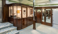
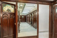
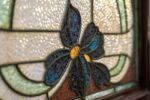
The Lavatory de la Madeleine, the first public toilet in France, has been restored to its belle époque splendor. Visitors will be able to urinate surrounded by floral stained glass windows, glossy mahogany paneling, brass taps, painted ceramic ceiling tiles, mirrored hexagonal pilasters and mosaic floors. They can enjoy period Art Nouveau posters and a display case of other period ephemera while they wait.

The toilets were built in 1905 underneath the Place de la Madeleine in 8th arrondissement of Paris by bathroom designers Porcher. They were showpieces, meant to convey the elegance, beauty and innovation of French design to meet the most lowly of public needs. Inspired by the luxurious public lavatories of Victorian London, it was decorated in Art Nouveau style whose characteristic stylized botanicals adorn the tiles, stained glass and paneling. This Madeleine facility was a women’s restroom. The men’s equivalent across the square is no longer a bathroom, repurposed to install technical equipment for the metro. The ladies room was converted into a unisex facility in the 1990s when some of the stalls were converted into urinals.

The Lavatory de la Madeleine were granted historic monument status in March 2011, just in time to be closed by the city. The mayor of the 8th arrondissement protested the closure, believing the bathroom could be a draw for tourism, but the city found that the traffic was too low (350 visits a day) to justify the maintenance costs. It was also impossible to make the toilets accessible while maintaining their historic character due to the entrance staircase and small stalls.

In 2015, the city council agreed to restore and reopen six exceptional historic toilets in Paris, in the Madeleine facility. Madeleine posed many challenges. It had been used as a rubbish dump after its closure and water infiltration problems caused damage so extensive that it has taken all this time to repair, and they’re not quite done yet. The mosaic entrance is still cracked and is now being studied to determine the cause of the problem before it is restored next year.

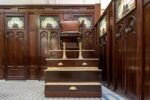
The restoration of the woodwork, glass and tiles was finally completed last month but the toilets, sinks and taps have been replaced with similar modern models. An old shoe-shine chair, preserved on the site, adds to the impression of entering a grand “throne room”.

This elevated excretory experience will cost you, unlike the other 435 public toilets in Paris which are free of charge. “You get what you pay for” applies here, however, perhaps better here than in any other context I’ve ever heard of. The €2 fee will cover the cost of an attendant and maintenance personnel tasked to clean the bathroom after every single visit. This will ensure it does not fall into gross disrepair again.

Monumental Armenian map digitized

A monumental map of Armenia in the University Library of Bologna has been digitized with gigapixel photo stitching technology that allows viewer to explore the image in ultra-high definition.

The Tabula Chorographica Armenica was commissioned by Luigi Ferdinando Marsili, a Bolognese nobleman, diplomat, soldier, world traveler, naturalist, author and all-around polymath whose unquenchable thirst for knowledge drove him to amass an enormous collection of manuscripts that is now at the University of Bologna. (Fun fact: The University of Bologna was founded in 1088 and is the oldest continuously operating university in the world. Its motto, “Alma Mater Studiorum” meaning “nuturing mother of studies,” is the origin of the term “alma mater” for the school you attended.)

Born in 1658, Marsili was privately educated and attended lectures in medicine, mathematics and botany at the renowned university. In 1680, his endless curiosity drove him to join a diplomatic mission to Constantinople where he spent his free time studying the seas. He invented new devices in order to study the coastline, currents, marine animals, water salinity and winds. He published these observations in his first book in 1681.

That same year, he joined the army of the Holy Roman Empire solely for the opportunity it afforded him to travel throughout Eastern Europe. When he was captured by the Ottoman Empire, he was made to distribute coffee to its soldiers besieging Vienna in 1683. So naturally he turned that experience into a treatise on coffee and its supposed medicinal effects.
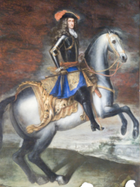
He was sent to Constantinople again in 1691. His mission was to test the waters (not literally this time) for a peace treaty between the Holy Roman Empire and the Ottoman Empire. He spent a year there. The negotiations went nowhere, but he put his unquiet mind to good use yet again by commissioning a monumental map of the Armenian church.

Armenians had been forced by Shah Abbas I of Persia to move into Persian territory in 1604 and in 1638, Persia and the Ottoman Empire divided Armenia between themselves. The Armenian Patriarchate had been established in Constantinople by express invitation of Sultan Mehmed II in 1461, so by the time of Marsili’s second stay in Constantinople, the city had been the most important center of Armenian religion, scholarship and culture for more than two centuries. Fascinated by the history of the Armenian church, its polemical debates with Roman Catholicism and Greek Orthodoxy, Marsili asked Armenian scholar, scribe and illuminator Eremia Çelebi K‘ēōmiwrčean and his son Tēr Małak’ia to map it all out for him.
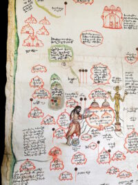
They crafted the large-scale map by gluing 16 sheets of paper to a canvas backing and then drawing hundreds of monasteries, churches and sanctuaries in the four catholicosates (a regional primacy headed by a single leader or catholicos) that existed in the Armenian Apostolic Church at that time. The complete map is 11 feet and nine inches long by three feet 11 inches wide.

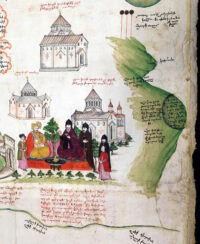
The most significant churches are accurately drawn and everything is fully captioned. The ink drawings were painted in with watercolors. The four catholicosates are color-coded so it’s clear at a glance which churches belong to which catholicosate. Palm fronds indicate a female hermitage while olive branches indicate a male one. Among the notable illustrations are Saint Gregory the Illuminator banishing a golden idol with a censer, and a meeting between the Catholicos and the Persian governor with the Etchmiadzin Cathedral to their left and Mount Ararat to their right. Annotations include a history of the Armenian church and a recounting of the commissioning and creation of the map.

The great map left Constantinople with Marsili who would continue to be heavily involved in the fighting and diplomacy between the Holy Roman Empire and the Ottoman Empire. Wherever he went, he parlayed his assignments into new research and treatises. His one big failure — the 1703 surrender of the fortress of Breisach to the French in the War of Spanish Succession — put paid to his career with the HRE and he returned to Bologna where he co-founded the Institute of Sciences that would be closely affiliated with the University. He donated his vast collection of manuscripts to the Institute just before his death in 1730.
The map was just one entry in a very long catalogue and was not published. Its existence only became known to Armenian scholars in the late 18th century, but the lore had some of the details wrong. K‘ēōmiwrčean was said to have created it for the “Ambassador of Austria,” so the map was sought in Vienna among the enormous Hapsburg holdings. Marsili’s name had gotten lost in the game of historical telephone, and nobody thought to check in Bologna for a map commissioned by an ambassador of the Holy Roman Empire.

Then again, not even Bologna knew what a treasure it had. It fell off the radar for three hundred years, re-emerging only in 1991 when researchers found it in the University Library while preparing for an exhibition of maps. The digitization project was also engendered by an exhibition, this time of Armenian material in the University Library of Bologna. The gigapixel image will be projected onscreen during the opening of the exhibition on Friday, February 17th. Those of us without reservations for the event can skip ahead and just explore the gigantic masterpiece on our own time.

Explore the full map here. Explore it divided into five sections for ease of navigation here.
Ancient cave sanctuary to be stabilized for visitors

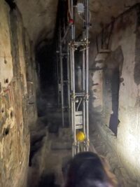
The Archaeological Park of Pompeii has embarked on a new plan to stabilize and conserve a 5th century cave sanctuary at the ancient site of Stabiae. Currently the Cave of San Biagio is closed to the public and hidden behind structural supports. Authorities aim to consolidate the cave and facing ridge with the ultimate goal of making it safe for visitors.

The Cave of San Biagio is located at the foot of the Varano Hill directly underneath the Villa Adriana, one of the Roman luxury villas overlooking the Bay of Naples in the ancient resort city of Stabiae, an exclusive enclave for the wealthy. The cave has lived many lives. It began as a side-effect of construction. Tufa was mined from the slopes of the Varano Hill in the 1st century B.C. to build the stately pleasure domes of Stabiae leaving five man-made caves.

Archaeologists believe one of the caves was used as a pagan temple before being converted to a Christian cemetery in the 5th century. It held the remains of members of one prominent Stabiae family and several other individuals. The cemetery became an oratory dedicated to Saint Michael by Benedictine monks in around the 7th century. They too used the cave to bury their dead, enclosing coffins in brick vaults from floor to ceiling.

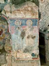
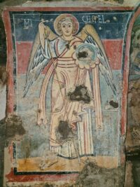
The cave is 33 meters long by three meters wide (108 x 10 feet), a numerologically ideal measurement in terms of Christian symbology. The entrance opens into a rectangular atrium supported by tufa arches. Traces of late medieval frescoes have been found on the atrium wall. The nave is decorated with frescoes on the left wall, including the busts of Saint Michael, Saint Raphael, Saint Maurus and the archangel Uriel. The walls were frescoed several times. The first cycle dates to between the 5th and 6th centuries, the second to the 10th and 11th centuries.

By the 14th century, the cave was described in contemporary records as a church dedicated to Saints Jason (the name changed over time into “Biagio”) and Mauro. The Benedictines continued to own the land and administer the sanctuary until they abandoned the site in the 17th century. Local rumors spread that there was a treasure hidden in the cave, making it a target for vandalism and looting. In 1695, church officials ordered it closed as it had become a wretched hive of scum and villainy. The sanctuary to the saint was removed and reinstalled in the cathedral of Castellammare di Stabia.

The abandoned cave was briefly used to store gunpowder in the 19th century, but its ancient history, human remains and frescoes were largely neglected save for one publication in the late 1800s. The Cave of San Biagio was finally explored systematically only in 1950. Archaeologist Libero D’Orsi was the first to investigate the cave, discovering the Christian burials dating back to late antiquity. The vaults built by the Benedictines to seal in their deceased brothers had collapsed and the fresco cycles heavily damaged by misguided treasure hunters.

Monitoring involves the execution of coring up to a lower quota than the tax level of the San Biagio cave, the positioning of inclinometers to measure any instability on the Varano ridge, topographic surveys, and preventive stratigraphic essays. The laboratory tests on the samples extracted from the cores will be carried out at the Federico II University of Naples, and will provide the data necessary for the continuation of the scientific activities

“It is a unique context to recover and enhance, which adds to the historical framework of the archaeological evidence of the Stabia area,” declares the Director Gabriel Zuchtriegel. “The whole territory is the object of great attention by the Archaeological Park which is investing a total of around 4 million Euros in Castellammare di Stabia in recent years. In addition to the investigations into the cave of San Biagio, we have a series of research, maintenance, restoration and accessibility projects in the field of the ancient villas on the Varano plain and a project to expand the Libero D’Orsi Museum at the Quisisana Palace. Given the uniqueness and complexity of the heritage present in the area, we can define Stabia as a true cultural giant and as such it must be told.”