Neolithic funerary urn found in Yorkshire barrow

Archaeologists have discovered a rare complete Late Neolithic funerary urn in Silsden, West Yorkshire. The clay vessel dates to around 3,000 B.C. and was buried in a prehistoric barrow discovered on the site of a future housing development. Because it was clear to the naked eye that there were archaeological features on site, a terrace on the north side of the River Aire, developers Barratt Homes engaged Prospect Archaeology (PA) to organize a seven-week excavation before construction began. PA brought in contractors Archaeological Services WYAS (ASWYAS) to evaluate and excavate the site.

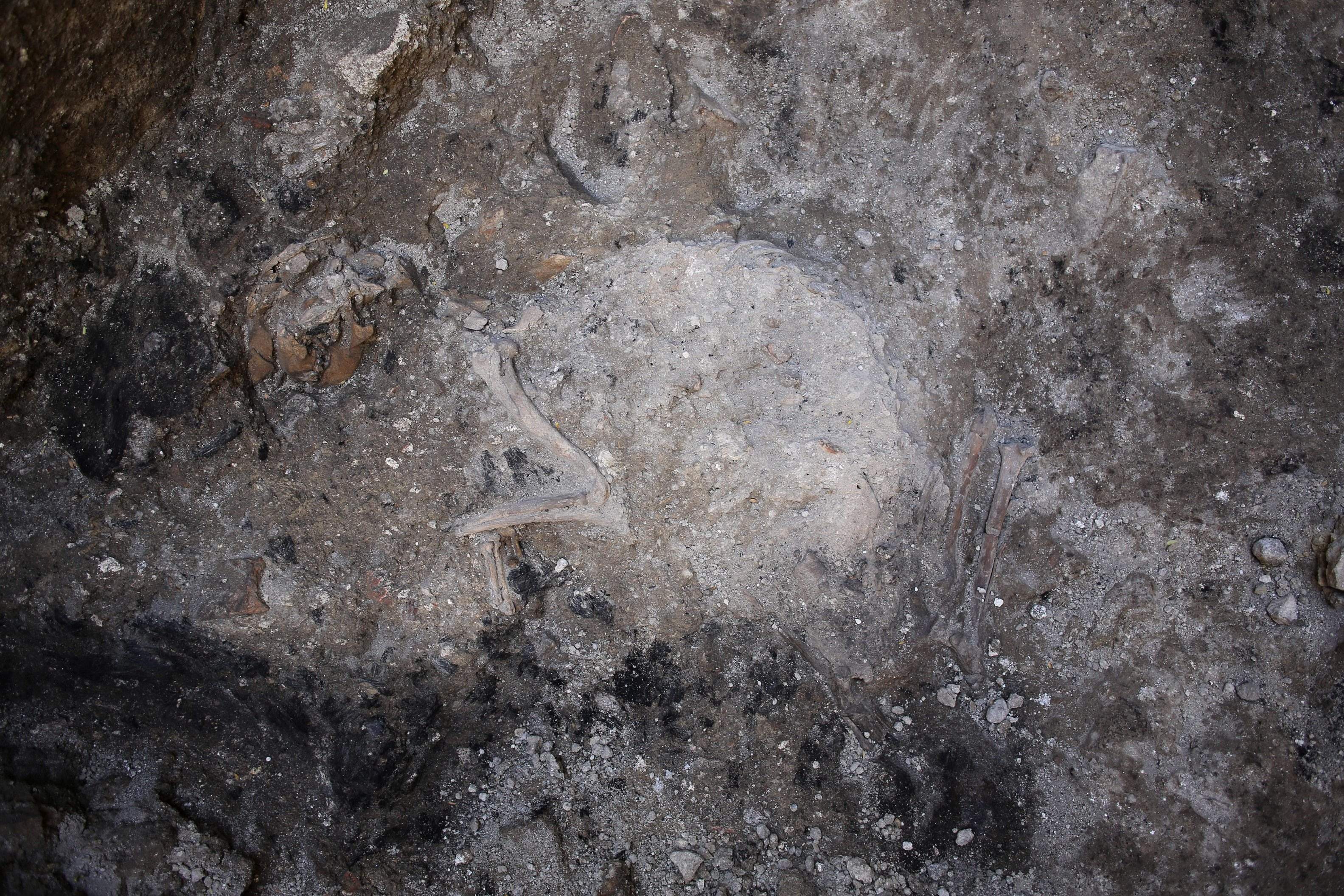
The ASWYAS team began with a geophysical scan of the property. The magnetometer picked up anomalous features consistent with Late Neolithic and Early Bronze Age burials. Excavation confirmed the results of the scan. Just under the surface of the terrace was a prehistoric barrow bounded by a double ditch. Few artifacts and remains were discovered, but the ones that were are notable. Among the few flints unearthed was a Neolithic leaf-shaped arrowhead, a later flint blade and most significantly, a complete collared clay urn. The artifacts, size and design of the barrow indicates it was first created around 5,000 to 4,500 years ago in the late Neolithic/early Bronze Age.

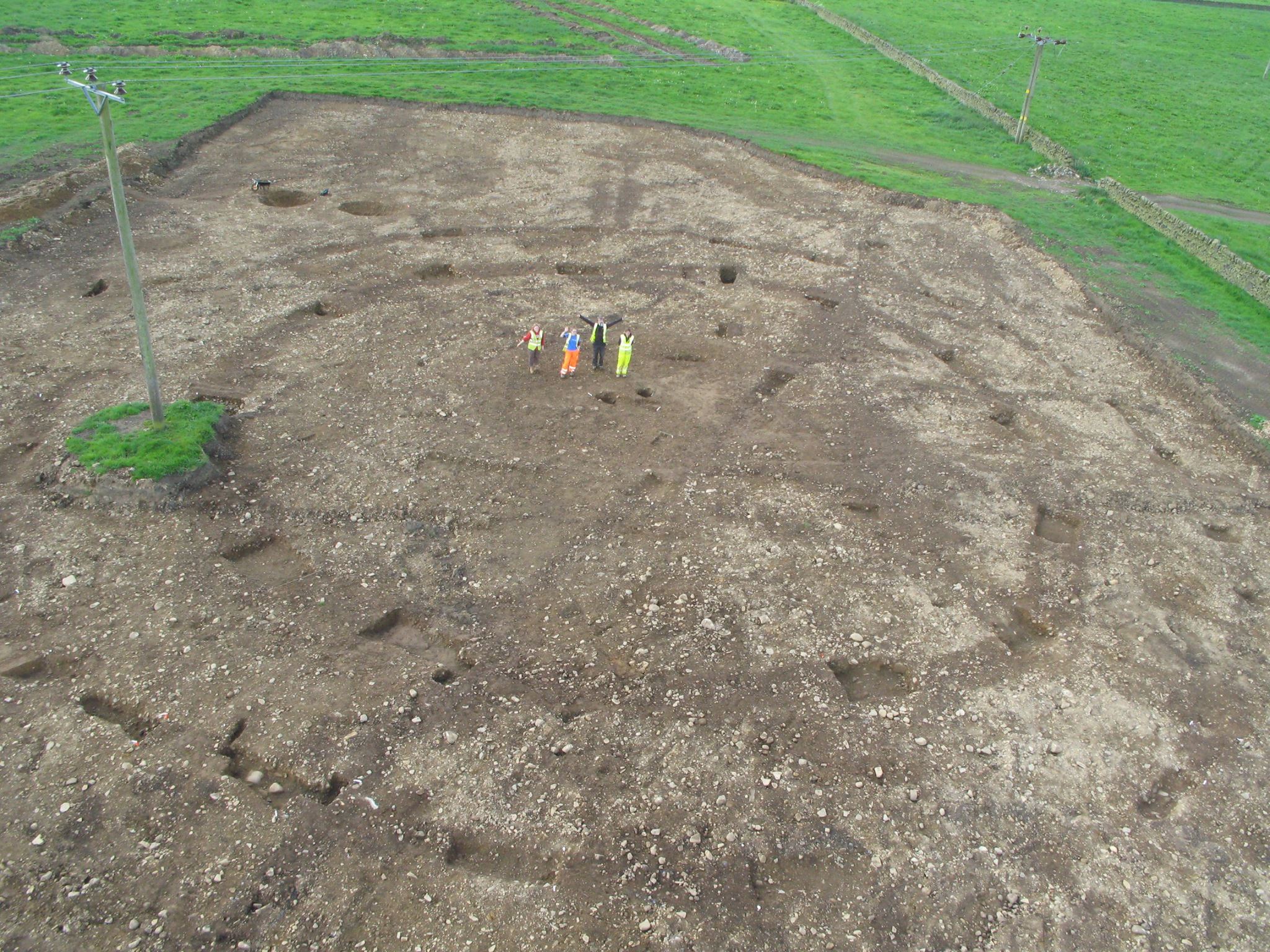
The barrow is only part of a larger complex. About 100 meters (330 feet) from the barrow is squared space enclosed by ditches is probably a mortuary enclosure, used in funerary rites that culminated in the barrow burial. On the outside of the barrow’s outermost ditch archaeologists found a pit alignment — a lined up series of pits that delimit an area in the same way boundary ditches do — that dates to the Iron Age, 1,500 years after the barrow was first made. Pit alignments are still somewhat mysterious. Archaeologists aren’t sure if they were dug that way in haste — some were later dug out into full-on ditches — or if there was a deliberate purpose to the pit design. Soil samples have been taken from the bottom of the pits so that they can be dated and analyzed for more information.

The large urn was decorated with engraved lines in the collar. These types of vessels are believed to have been used primarily for burial or other ritual purposes. The Silsden pot falls into line with its brethren. It was found buried in a pit near the center point of the round barrow. Archaeologists believe it was the primary burial, the reason the barrow was built. This pot was not the only burial found in the barrow. Other pottery vessels that may contain human remains and a later cremation burial were unearthed from the barrow and its associated ditches. That means the barrow was recognized and used reverently for hundreds of years well into the Bronze Age.

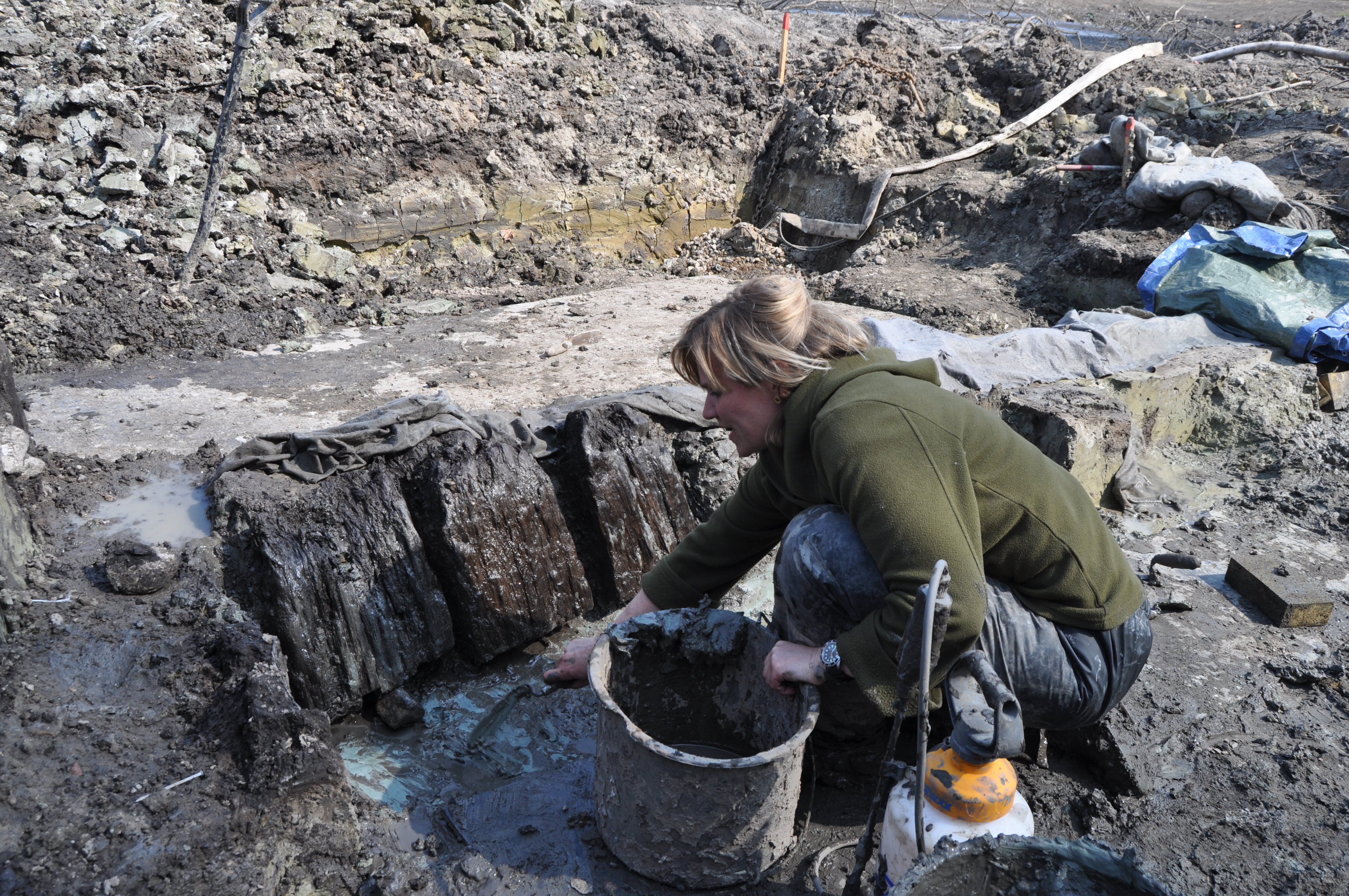
To ensure its precious contents, which may still contain human remains, were not disturbed or worse, carried away by a stiff breeze, during excavation in situ, the main pot was wrapped on site and raised intact so it could be transported safely to the conservation lab and excavated in a contained and controlled environment. After excavation, conservation and study, the funeral urn will probably go on display at the Cliffe Castle Museum.

The excavation of the Silsden site also found later remains, mainly evidence of agricultural usage like field ditches, ridge and furrow cultivation from the Middle Ages, and relatively new features added in the 18th and 19th centuries. One of them in particular deserves a spotlight dance: a dry stone wall built to mark a boundary line or enclose a field. It is a real beauty and I feel compelled to give it a vigorous, even vehement, Charles Foster Kane clap. I love a great dry stone wall, and apparently Yorkshire is crisscrossed with them, like a great patchwork quilt with masonry seams. The craft is still very much alive, with drystone walling associations and training programs to ensure there will be a new generation of builders keeping the tradition, and any historic walls in need of repair, standing proud.

Archaeologist on vacation finds ancient figurine

Archaeologist Piotr Alagierski was enjoying his vacation, taking a leisurely Sunday stroll through a farmed field in the southeastern Poland village of Kosina when he came across a small clay figurine. Just seven centimeters (2.8 inches) long, the little man was missing some of his parts. Only his head, torso and one arm or hand remain. What was left of him was enough for Alagierski to conclude that the fired clay piece is a Neolithic figurine that may be as much as 7,000 years old.

If that age is confirmed, it will make the figurine one of the oldest depictions of a human ever found in Poland and an object of national significance. Even among the few pieces from this period that have been found, he is extremely rare. The others have the voluptuous bodies and exaggerated sex characteristics frequently seen in prehistoric mother figures. All the detail in these types of figures tends to be centered on the breasts, belly and genitalia, not on facial features or adornments. The Kosina figurine takes a different approach.

“The style in which the figurine was made is surprising. It resembles similar figurines from Slovakia and Romania” – explained [Piotr Alagierski]. […]

“It is different in this case. The details of the head are clearly modelled – the hair, the nose, the chin are visible. There is a visible indentation on the chest, probably representing a garment, probably a tunic. A necklace is visible on the neck” – the archaeologist described. Contrary to the few figurines from this period previously found in Poland, this one does not have prominent sex features.

“In the field around the figurine I also noticed large quantities of fragments of ceramic vessels and obsidian, volcanic glass, which is produced by the instantaneous cooling of the lava. This material is also known from the areas of Poland’s neighboring countries: Ukraine and Slovakia” – Alagierski described in an interview with PAP.

Alagierski believes the area where the figurine was found was an agricultural settlement founded by some of the first farmers to make a living from the land in what is now Poland. That’s what he’s basing the date of the figurine on — that there was a farm on the site from early in the shift to agriculture, and that the figurine is contemporaneous with said settlement — which seems tenuous to me so early in the investigation.

We may get some firmer answers soon. Alagierski plans to excavate the site to find material evidence of the settlement and to flesh out the context in which the figurine was discovered. The figurine itself will also be studied. Researchers will run a series of chemical analyses that will determine where the clay came from. Given the objects and materials Alagierski saw in the field, it’s possible that the clay may not have been local, but rather from north of the Carpathians, which would suggest either population movements or trade with neighbors to the north.

The figurine is now in the custody of the Regional Office for the Protection of Monuments in Rzeszow.

Wood beams, furniture preserved by fire found in Rome

The construction of Rome’s Metro Line C continues to be the archaeological gift that keeps on giving. The latest discovery is an early 3rd century villa that collapsed in a fire. The intense heat of the blaze charred wooden beams and the collapse of the structure on top of them helped preserved the organic remains for 1,800 years.

Organic remains preserved by instant carbonization have been found at Pompeii and Herculaneum, but those cities succumbed to a cataclysmic volcanic eruption that froze everything in time. Buildings burned down in Rome all the time, some fires spreading rapidly throughout the city like the Great Fire of 64 A.D. over which Nero is said to have sung mournfully about the destruction of Troy, some relatively contained either by (rudimentary) firefighting measures or by a fortuitous separation between buildings.

Surviving organic remains, however, are extremely rare in the city of Rome. Even though the tightly-packed, wood-heavy ancient city was subject to regular conflagrations, most of the evidence for them in the archaeological record consists of marks, dark spots indicating charring. Thousands of years of battling the water table and Tiber floods and construction over construction have made Rome a tough environment for the preservation of wood, textiles and organics of any type. The discovery of fire-preserved wood from a villa in the city is therefore an extremely exciting find.

“The fire that stopped life in this environment allows us to image life in a precise moment,” said Francesco Prosperetti, in charge of Rome’s archaeological ruins and excavations.

Experts say the Rome ruins might be from an aristocrat’s home at the foot of the nearby Celian Hill or from a nearby military barracks, which itself had been explored in other excavations for the subway line.

The remains were discovered last month at the bottom of a 33-foot hole bored into Rome’s undercarriage near the ancient Aurelian Walls (built between 271 and 275 A.D.). The most significant find was a charred wooden ceiling that collapsed during the fire. It is unique in Rome’s archaeological record. Pieces of furniture, hardened by the fire, also survived: the leg of a stool or table, a larger leg or foot believed to have come from a trunk, and two tables, one large rectangular one, one smaller piece. Other surviving wooden architectural features include a wooden railing or balustrade, rectangular wooden joists that acted as anchors for the rods that attach the plaster to the ceilings and walls, and a large support beam for the floor that Vitruvius described in De architectura as a contignatio. The beam still has notches where the transverse beams were once installed and a large iron nail driven into the middle of it. Fragments of a wooden window jamb with traces of the glass panes still extant were also found.

Non-organic features have survived in fine condition as well. There are frescoed sections of brickwork wall dating to the reign of Emperor Septimius Severus (late 2nd, early 3rd century) decorated with delicate red florals against a white background. Part of a black-and-white mosaic floor that had once been on the upper story of the building survived its plummet with its handsome double border, heart-shaped leaves and wave pattern intact.

Dog skeleton. Photo courtesy the Italian Culture Ministry.In another nod to famous Pompeiian finds, the skeleton of a dog still posed in the crouching stance it was in when it died, was found at the door of the house. Archaeologists think it was trying to escape the fire but was trapped by falling debris when the building collapsed. The dog’s jaw complete with teeth has remained surprisingly intact. The skeleton of a second smaller animal found at the site, possibly the dog’s puppy or a cat, has yet to be identified.

The architectural and decorative materials are all in good state of preservation thanks to the fire, and archaeologists will study them in detail to discover new information about how wealthy Romans of the 3rd century lived, how their homes were built and furnished. Italy’s National Institute of Geophysics and Volcanology (INGV) will also study the site. They hope to determine whether the fire and collapse were caused by an earthquake.

Touch a 1,000-year-old Viking palisade

The town of Jelling in Jutland, Denmark, was the seat of the earliest kings of Denmark in the 10th century. Today the Jelling complex consists of two large burial mounds, two monumental runestones and a small church built on the site of three earlier wooden churches going back 1,000 years. The combination of tumuli, runestones and church capture the transition from the traditional Norse religion to Christianity. King Gorm the Old, the first king of Denmark, dedicated the smaller and older of the runestones. The inscription translates to: “King Gormr made this monument in memory of Thyrvé, his wife, Denmark’s adornment.” His son Harald Bluetooth had the second, much larger stone raised and its runic inscription reads: “King Harald bade this monument be made in memory of Gorm his father and Thyra his mother, that Harald who won for himself all Denmark and Norway and made the Danes Christians.”

Within the perimeter of Jelling, the massive cultural shift from the reign of Gorm (936- ca. 958) to that of Harald (958– ca. 986) is documented in language, funerary and religious architecture. That’s why the Jelling mounds, runestones and church are on the UNESCO World Heritage List and why the site is one of the most important in Danish history.

In 2006, archaeologists were able to explore a previously inaccessible area: the bed of a pond across from Gorm’s Mound. Before a planned renovation, the pond was pumped dry giving archaeologists the opportunity to excavate the mucky bottom looking for remains of the large wooden stockade that once encircled the royal estate at Jelling. Postholes from the stockade had been found before, but no physical remains. The stockade was known to have intersected part of what is now the pond, and therefore there was a chance the thick clay and mud on the bottom of the pond had preserved the organic remains of the stockade’s timbers. Viking-era reports suggested there had been a body of water in the area when the stockade was built, so conditions for preservation of wood may have existed on site since the 10th century.

Excavation along what was believed to be the stockade line hit the jackpot almost immediately. Just over two feet under the pond bed surface, archaeologists unearthed four large oak posts. Radiocarbon dating of samples taken from three of posts found that all samples were approximately 1,000 years old. In later excavations (2012-3), archaeologists found vertical stakes also made of oak. They are 4-5 inches thick and were driven directly into the clay of the pond bed two-by-two. There was no ditch dug into the soil first as in evidence elsewhere along the palisade line. This could only have been accomplished if the site was already watery when the stockade was built in the 10th century by Harald Bluetooth who greatly enhanced the Jelling defenses.

King Harald’s stockade was a huge, kite-shaped fence measuring around 1180 x 1180 feet, totaling just under a mile of wooden palisades at least 10 feet high. There’s evidence of some sort of superstructure at the top of the fence, perhaps a parapet for defenders to patrol. It is by far the largest Viking fenced-in space ever discovered in Denmark or Scandinavia. It’s also the only kite-shaped palisade known. The discovery of the timbers has been a boon to research on the architecture and layout of Jelling. Excavations also unearthed evidence of three different longhouses and a boat burial, although no boat remains have survived.

So far, the oak posts and vertical stakes are all of the physical remains archaeologists have found of the stockade. One of their dearest wishes came true when they found a timber large enough among the thick, square planks to be dated with dendrochronological examination (i.e., tree ring counting). The wood posts and stakes were recovered from the pond site and transported to the National Museum’s Conservation Department in Brede. They were dendrochronologically dated to between 958 and 985 A.D., with 968 A.D. the likeliest year for the felling of the oak tree.

Vertical oak planks from the defensive stockade at Jelling, 10th century. Photo courtesy the National Museum of Denmark.Even if the widest dates prove accurate, these years fall squarely into the reign of Harald Bluetooth, confirming the timbers found were part of Harald’s defensive expansion. After four years, the timbers have been stabilized and will go on display starting June 29th at the National Museum’s Jelling branch. The exhibition will explain to visitors the challenges in building such a huge structure in Jelling a thousand years ago. Just securing enough large oak trees for a palisade a mile long would have been enormously difficult; cutting them down, processing them and carrying them to Jelling added exponentially to the level of difficulty.

The surviving wood planks and posts will be displayed in custom cases, protected from light, heat, fluctuating moisture levels, humans and the wide variety of damaging microorganisms we take with us wherever we go. All except for one small fragment from the palisade that would have disappeared compared to the larger pieces behind the glass. Curators therefore decided to allow guests to touch a piece of a 10th century Viking stockade that once enclosed the royal compound of kings Gorm and Harald. Since it was Harald Bluetooth who ordered this stockade built, it’s eminently possibly that he even touched that same sliver of wood that Jelling visitors will now get to touch.

Original 1953 Disneyland concept map sells for $708,000


The first map of Disneyland, created in a single frenetic weekend of 1953 by Walt Disney and Disney artist Herb Ryman, sold at a Van Eaton Galleries auction in Los Angeles on Sunday for $708,000. That’s on the low-end of the $700,000 to $900,000 pre-sale estimate — some breathless reports before the auction suggested the price could top $1 million — but it still sets a record for the most expensive Disneyland map ever sold, even though it’s not an actual map of the real life Disneyland.

The map was created to use in a pitch to a potential investor, the television studio ABC which was then just five years old. Walt Disney’s idea for a theme park nestled in the orange groves of Anaheim, California, sounded like a cockamamie scheme to most money people and Walt and his brother Roy were repeatedly turned down. Walt was so convinced this was a winning idea that he refinanced his home to raise money for the enterprise, but it wasn’t anywhere near enough. Construction of Disneyland would cost $17 million and to convinced financial types to invest that kind of money, Walt realized he needed to create a visual representation of his idea so they could get it without having to use their limited imaginations.

On September 26th and 27th, 1953, the weekend before Roy Disney’s pitch meeting with ABC executives in New York City, Walt Disney and Herb Ryman sealed themselves in to a room at Disney Studio a drew up a map. Disney told Ryman what to draw, and Ryman penciled his boss’ vision on a sheet of vellum. He then transferred the drawing to more durable paper and hand-inked and colored it. The map was mounted on a three-fold presentation board and Roy Disney hustled it off to New York to present Walt’s vision to the ABC people. It worked. In exchange for a Disney-produced TV series to be aired on the network, ABC agreed to finance the construction of Disneyland, still the biggest network deal in history adjusted for inflation. (Disney bought all of ABC’s shares of Disneyland in 1960 and 36 years later bought ABC itself.)

In October, Roy brought the map back to California where it was used throughout 1953 and 1954 to show designers, investors, engineers and artists what Walt had in mind. It was altered several times in 1954 — lines darkened, colors added, new cars hooked up to the train, the scroll gussied up — and was repeatedly featured in the advanced publicity materials from September 19th, 1954, until the park’s opening on July 15th, 1955.

It didn’t keep up with the planning, though. Land of Tomorrow on the map became Tomorrowland in the park. Frontier Country became Frontierland. Lilliputian Land never happened at all. Sleeping Beauty Castle, the center point of Disneyland, is way at the back of the park in the concept map. The train station and Main Street square do match up with the real Disneyland.

Even though the map had been essential to securing the funding for Walt Disney’s brainchild and in promoting it in the months before its opening, Walt gave it away without hesitation before the park was even completed. The lucky recipient was one Grenade Curran, a show business veteran and jack of all trades who worked at Walt Disney Studios.

Grenade’s father was Charles Curran, an adept with the hand-held camera who became both Clark Gable’s and Roy Rogers’ personal cameraman. His mother had been an MGM dancer in her youth and had a very successful later career in the studio’s scenic art department. With an uncle and cousin in the business as well, Grenade grew up on the backlots of Hollywood. He was buddies with some of the most famous actors of all time and their children. From the time he was a baby, he was in front of the camera in commercials and movies. As an adult, he followed in his mother’s proverbial footsteps and worked as a background dancer in classic MGM musicals like Singin’ in the Rain, Seven Brides for Seven Brothers and The Band Wagon. Over his decades in the business, he also worked behind the camera, touching every aspect of production from wardrobe to set design to direction.

In 1954 he got his first job with Walt Disney Studios working as a safety diver on 20,000 Leagues Under the Sea starring Kirk Douglas. Several other behind-the-scenes jobs followed in Disney pictures and television shows. Walt Disney knew Curran’s family and he took a liking to Grenade, not the least because of his undeniably kickass first name. So even though he was just a regular production guy, not an executive, animator or an artist, Grenade found himself in the middle of historic events thanks to that jocular rapport he had with Disney.

After the deal was struck in New York, Walt Disney showed Grenade the first check from ABC and the check the mortgage company gave him when he refinanced his home. Grenade also saw the map, witnessing artists make changes and additions at Disney’s command. In March of 1955, Grenade asked him what he planned to do with the map and then boldly asked if he could have it. Walt said yes and Grenade Curran became the proud owner of the first map of Disneyland.

Construction on the park began in 1954 and on July 15th, 1955, Disneyland had its World Premiere Invitational Opening broadcast live on television and hosted by Art Linkletter, Ronald Reagan and Robert Cummins. Walt Disney assigned Grenade Curran to drive one of the Autopia cars in the very first Main Street Parade led by Mickey Mouse and Donald Duck. Actor Don DeFore road in the car with him.

The opening was supposed to be an invitation-only preview, a show for celebrities and tantalizing glimpse brought to the rest of the country by ABC, but word got out and the public showed up in droves. The park, which was still under construction as of that morning, wasn’t even remotely ready for the 50,000 people who clamored to ride the teacups, moon over Sleeping Beauty’s Castle and squeal with delighted horrors through Snow White’s haunted forest. The asphalt on the streets melted in the 100 degree Anaheim heat. The toilets backed up. Everything that could go wrong did go wrong. And yet, the massive failure of the opening day was also proof that Disneyland was a major draw, would make all of its costs back lickety-split and basically turn out to be a license to print money.

Curran knew when he got the map that it was significant as a piece of history and a unique example of Walt Disney’s creativity and his team’s artistry. When Disneyland’s success birthed a myriad theme parks all over the world, he realized the map marked the beginning of a global cultural phenomenon. He kept it for 25 years before selling it to avid Disney collector Ron Clark. Clark has had it in a vault ever since. The map went on display for the first time in more than 60 years earlier this month at the auction preview.

The buyer has chosen to remain anonymous but appears to be a private collector. Clark had hoped the map would be acquired by Disney so it could go home, but they must not have been bidding because there’s no way a company with pockets as deep as Disney’s wouldn’t push the hammer price above the low estimate.