 As impressive as the work done by the Allied photo reconnaissance airmen in World War II is, they were following in some truly huge contrails. It was World War I that ushered in the era of aerial reconnaissance, and not just from dirigibles (which I already knew about) but from two-seater biplanes. Picture the size of a 1914 camera. Now picture a rickety biplane, just 11 years newer than the one the Wright brothers flew, with one of the pilots holding said giganto-camera over the edge of the plane taking pictures from 12,000 feet in the air.
The mere effort of holding the equipment steadily enough to take a crisp picture is mind-boggling. Then on top of that, they had to take photos while fighters on the ground and in other airplanes were shooting at them. The death rate for pilots was higher than for infantry in the trenches. (They weren’t given parachutes because the powers that be decided that would encourage pilots to bail out instead of doing everything in their power to return the plane to safety. Hey, those planes were expensive, dammit! And a lot harder to find than men for the meat grinder.)
Through all of this, the fly boys somehow managed to take millions of reconnaissance pictures, 500,000 surviving in various European archives, which showed enemy positions in a heretofore unknown detail. For the rest of us, the surviving photographs reveal the seismic destruction of World War I in heretofore unknown detail.
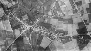
Here is the Belgian town of Passchendaele, a charming village north-east of Ypres, in 1916:

That’s the town center along that curving road, with the church right in the middle, houses along the roads and a lovely quilt of farmland and pasture all around.
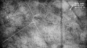
Here is Passchendaele in November, 1917, after the Third Battle of Ypres drenched the area in steel showers off and on for 4 months:

Yeah. What did the Allies gain, you ask, other than a nightmare moonscape in place of a cute village? They gained 5 miles and a 140,000 dead, about 2 inches of ground per dead soldier. The Germans got those 5 miles back without resistance 5 months later.
The Imperial War Museum in London has a large collection of 150,000 WWI aerial photographs. They’ve been sorely underused by historians so far. There hasn’t been a systemic analysis of all the surviving pictures; many of the glass plate negatives haven’t even been printed yet. The BBC will be airing a documentary about these pictures this Sunday, November 7th, at 9:00 PM.
whoa! The devastation depicted in the comparison of those two images is horrific.
After looking at the additional pics on the BBC site, you are not kidding about the skill displayed to hold the giganto-camera steady to capture the images.
I wish I could watch the documentary on this side of the pond.
Me too. BBC’s proprietary video makes me a sad panda. I guess that’s how people in the UK feel about Hulu. 🙁
Stunning find. For WW1 enthusiasts, this footage and these pictures are sombre treasure. Absolutely fascinating.
Very much agreed. It’s a miracle the glass plate negatives survived at all, never mind in such large numbers.
Just watched the documentary, I’ve always been a sponge for anything WW1. My great Grandfather was in a special company in Ypres. This film is absolutely fascinating I agree. Wouldnt it be great if it was compulsory viewing in every school in the country. NEED I SAY MORE !!!
I am awash in waves of jealousy. I might have to indulge in a little IP masking to watch it on the BBC website. 👿
Terrific documentary, Brings home to you what our Tommies endured. Such a terrible waste of good lives. Cannon Fodder comes to mind.
A poor documentary regurgitating the usual ‘lions led by donkeys’ claptrap. Lazy or non-existent research and a waste of the aerial resources the film makers had at their disposal. A much better script would have cost them no more! Just get someone who knows the subject to write it…
Ooh, a dissenting voice. I still haven’t seen the documentary myself due to technical difficulties so I can’t agree or rebut. Also, I have fairly low standards for historical TV documentaries thanks to the atrocious degeneration of quality from the likes of The History Channel. I’m pathetically grateful when Nostradamus, Atlantis and 2012 don’t play starring parts in the narration.
I was shocked to hear Fergal Keane say that the trenches stretched “from Switzerland to the English Channel” – and the other bloke with him in the trenches repeated it. The trenches were between Switzerland and the North Sea. This isn’t just geographical pedantry – a major German strategic goal was to gain control of one or more Channel ports which would have made supplying the BEF extremely difficult.
Also, he says that at the start of the war men had only been flying for ten years. True enough for aeroplanes but aerial photography had been around since 1858 thanks to balloons and airships like the one this programme was built around.
Found the documentary on youtube. it works for me in arizona.
https://www.youtube.com/watch?v=I-2j9lU2hoE