Archaeologists knew the ancient Roman city of Altinum was underground somewhere just north of Venice, but it’s been farmland for a thousand years and there are no standing ruins whatsoever.
Thanks to a severe drought and the marvels of aerial photography, now the whole city can be seen again without anybody digging an inch.
People began to flee Altinum starting in the 5th century when Atilla invaded Italy until finally the 7th c. Lombard invasions drove the last inhabitants to the more defensible lagoon islands. Then what with the marshy terrain and the “borrowing” of building materials, the city disappeared and cultivated land took its place.
That makes Altinum a very rare thing indeed: a prominent Roman metropolis that was never rebuilt. You can see why archaeologists were keen to find it.
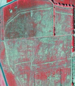
In July 2007, during a particularly dry summer, crops were suffering from drought and were highly sensitive to the subsurface presence of stones, bricks or compacted soil. On the image taken by the mapping company Telespazio, the lighter crops indicated stonework, while the darker patches revealed depressed features such as pits and canals.
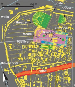
The team, reconstructing the town using the aerial images and knowledge of Roman architecture, was able to identify temples, theatres, a basilica, the marketplace and city walls as well as hundreds of smaller structures. Also visible is a large canal, which would have been used for the transportation of oils, wines and foreign luxuries inland to the Roman capital of Milan and other powerful cities such as Verona.
“Everything is just as it was. When we saw the picture we couldn’t believe it,” said Alessandro Fontana, an archaeologist at the University of Padua and a co-author of the paper, which is published today in the journal Science.
Here’s a link to the full Science article, although it’s available only to subscribers of which I am sadly not one.
I did manage to find the pictures, though, so without further ado, meet Altinum, aerial photo on the left, map on the right.

