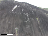
 Large rock art panels discovered recently on islands in the Atures Rapids in the Amazonas region of western Venezuela have been thoroughly mapped and studied for the first time by researchers from University College London (UCL). The engraved images of animals, people and symbols were carved by local people up to 2,000 years ago. (Shortly after the Spanish arrived, Jesuit missionaries identified the Adoles as the inhabitants of this area, but we don’t know who was there before.) Thanks to the historically low level of the Orinoco River, more petroglyphs have been exposed. Researchers found eight groups of rock art on five islands. Some of these engravings, individual and as a group, are huge. One panel is festooned with 93 petroglyphs over an area of 3270 square feet. A horned snake from another panel is 100 feet long just on its own. These are some of the largest rock art panels ever found anywhere in the world.
It was a challenging task recording such large and spread-out petroglyphs carved into high rock faces in the middle of the Orinoco River. That’s why this study is unprecedented. Others have studied the artworks, but were not able to get anywhere near as close and as a detailed a view as the University College London archaeologist. The team employed robot aides in the form of drones to take aerial overhead pictures of the engraved surfaces that were out of puny human reach. Every petroglyph was documented in photographs and their dimensions and positioning measured using photogrammetry (a technology that derives precise spatial data from photographs by creating 3D renderings of the pictures). Researchers also studied the relationship between the Atures Rapids petroglyphs, their archaeological and cultural context and the links they suggest between the locals who carved them and other indigenous peoples of pre-Hispanic Latin America.
The paper’s author Dr Philip Riris (UCL Institute of Archaeology) said: “The Rapids are an ethnic, linguistic and cultural convergence zone. The motifs documented here display similarities to several other rock art sites in the locality, as well as in Brazil, Colombia, and much further afield. This is one of the first in-depth studies to show the extent and depth of cultural connections to other areas of northern South America in pre-Columbian and Colonial times.”
“While painted rock art is mainly associated with remote funerary sites, these engravings are embedded in the everyday – how people lived and travelled in the region, the importance of aquatic resources and the seasonal rhythmic rising and falling of the water. The size of some of the individual engravings is quite extraordinary.” […]
In one panel surveyed, a motif of a flautist surrounded by other human figures probably depicts part of an indigenous rite of renewal. Performances conceivably coincided with the seasonal emergence of the engravings from the river just before the onset of the wet season, when the islands are more accessible and the harvest would take place.
The research is part of the Cotúa Island-Orinoco Reflexive Archaeology Project, funded by the Leverhulme Trust.
Principal Investigator, Dr José Oliver (UCL Institute of Archaeology), said: “Our project focuses on the archaeology of Cotúa Island and its immediate vicinity of the Atures Rapids. Available archaeological evidence suggests that traders from diverse and distant regions interacted in this area over the course of two millennia before European colonization. The project’s aim is to better understand these interactions.”
“Mapping the rock engravings represents a major step towards an enhanced understanding of the role of the Orinoco River in mediating the formation of pre-Conquest social networks throughout northern South America.”
The UCL research team’s findings have been published in the journal Antiquity and can be read here. It’s openly available for now (be warned: that could change) and makes a fascinating read.