
Gardener finds Denmark’s oldest figure of Christ

Landscape gardener Dennis Fabricius Holm picked up his first metal detector just two and a half months ago. It was his son’s, a Christmas present he’d gotten years before and never used. Holm fished it out of the basement and took it to the empty field next door to his home in the village of Aunslev on the Danish island of Funen to do a few hours of scanning every Friday afternoon. He found some buttons and small coins, nothing to write home about.

Last Friday, March 11th, Holm found something to write history books about. In an area of the field he hadn’t scanned before, his machine alerted him to a metallic object not made of iron. A mere four inches under the surface he found a little gold pendant 3.5 centimeters (1.4 inches) wide and 4 centimeters (1.6 inches) high, weighing 14 grams. The artifact’s fine filigree showed through the caked dirt. Excited about his find, Holm posted pictures of it on a Facebook page for Danish metal detector enthusiasts and was quickly deluged with congratulations.

He contacted Malene Refshauge Beck, an archaeologist and curator at the East Funen Museums, who identified it as a crucifix from the first half of the 10th century. That makes it the oldest figure of Christ ever discovered in Denmark. Before this find, the Christ figure engraved on the largest Jelling Stone, a massive runestone raised by Harald Bluetooth in around 965 A.D., was the oldest known in Denmark. It was a fitting record for a stone whose runic inscription reads: “King Harald bade this monument be made in memory of Gorm his father and Thyra his mother, that Harald who won for himself all Denmark and Norway and made the Danes Christians.”
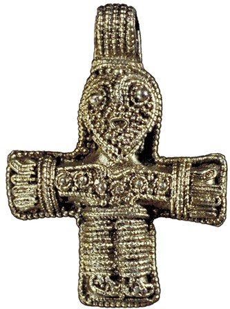
The pendant could be dated with such precision because it is almost identical to a pendant found in Sweden. The first crucifix of this design was unearthed in 1879 from grave 660 in a Viking cemetery at Birka, an 8th century town about 20 miles west of Stockholm. The earliest Christian missionaries who went to Sweden in the 9th century were centered in Birka. The town was destroyed in the 10th century and never rebuilt. Its ruins were rediscovered by an entomologist, Hjalmar Stolpe, who was there to study ancient insects trapped in amber. When he found large quantities of non-native amber on the island, he realized it must have once been an important trading center and so began archaeological excavations that would continue for almost 25 years, from 1871 through 1895.

A fragmentary second crucifix of the Birka type has survived. Their designs are so similar that archaeologists believe they were made by the same craftsman. East Funen Museums archaeologists will now contact their counterparts at the Swedish History Museum in Stockholm, where the original Birka crucifix is kept. The two crosses will be compared to determine whether they were made by the same hand.

The Aunslev crucifix is the most precious of the three. The first Birka crucifix is gilded silver with much of the gilding worn off. The fragmentary second one is silver. Holm’s find is solid gold. The goldsmith shaped a thin gold wire in parallel lines and small balls called granulation. It would have been a very expensive piece, likely worn by a woman.

Christianity was introduced to Denmark via the elite so this pendant probably belonged to someone wealthy and influential. Whether that person was Christian is impossible to know since the piece was found in a field, not in a grave like the others. Wearing a crucifix could be advantageous when dealing with the already Christianized peoples south of Denmark, and even if the wearer did espouse Christian beliefs, at this stage the new faith often coexisted with the traditional one of Thor and Odin. Indeed, Christ’s expression on the crucifix is not the one of a suffering man near death, but rather of a fearless warrior akin to the Norse heroes and deities.

The pendant is now at the Viking Museum in Ladby where it will be cleaned and conserved. It will be put on display this summer.

Shipwreck from Vasco da Gama’s 2nd voyage to India found

A rare early shipwreck from Vasco da Gama’s second voyage to India (1502-1503) has been discovered off the coast of Oman. It is the earliest Age of Discovery ship ever found and thanks to its remote location, archaeologists got there first.

Portugal sent ships on an annual journey to India, the Carreira da India, since Vasco de Gama discovered the sea route in 1498. It was a long, arduous, and very dangerous journey in the open ocean down the full length of west Africa, across the Cape of Good Hope, north up the east coast to Mombasa, modern-day Kenya, then across the Indian Ocean to Calicut (Kozhikode) in southern India. Many ships and men were lost on the India Route — one study found 219 ships were wrecked between 1498 and 1650 — and yet, very few shipwrecks have been discovered, and the few that have been were stripped bare by looters before archaeologists had a chance to explore them.

Without their contents, ships area difficult to date. The earliest Carreira da India wreck that could be conclusively dated is the São João which sank in 1552. The lack of an archaeological record for those first 54 years have left a large gap in our understanding of the early Portuguese trade to and from India. Hoping to find a wreck from that 54-year gap, researchers scoured archives looking for the possible location of two ships — the Esmeralda and São Pedro — that sank during Vasco da Gama’s second voyage to India in 1503. The two ships were captained by Vicente and Brás Sodré, brothers and da Gama’s maternal uncles, and led an independent squadron in the fleet that had separate military orders directly from Portuguese King Dom Manuel I to “make war against the ships of Meca” on the Malabar coast and corner the spice trade.

In 1503, after da Gama had returned to Portugal with the bulk of the fleet, the Sodrés went above and beyond their orders, leaving the Indian Ocean for the Gulf of Aden where they attacked and pillaged Arab ships of their cargoes of spices, prized textiles, sugar and rice. When one of the lead ships needed repairs, the squadron was moored off an island now known as Al Hallaniyah, 28 miles from the south coast of Oman. A violent storm broke them to pieces. Everyone on the Esmeralda died, including commander Vicente Sodré. Brás Sodré and most of his crew survived the wreck of the São Pedro, although Brás died a short time later of unknown causes.

The Sodré squadron’s special status, military adventurism/piracy and the demise of the lead ships made for an especially rich documentary record with multiple extant accounts of the voyage and wrecks, including an eye-witness report from the captain of another ship in the squadron. The research determined that the island where the ships had wrecked was likely Al Hallaniyah. Based on the findings, a 1998 expedition searched the area and found dozens of round stone shot and lead-iron shot typical of 16th century heavily armed ships.

The remoteness of the location made a full investigation difficult. It wasn’t until 2013 that shipwreck recovery experts Bluewater Recoveries Ltd. partnered with the Oman Ministry of Heritage and Culture to excavate the site. A geophysical survey was followed by an extremely complex excavation and artifact recovery project which ultimately retrieved 1911 objects. The ship itself is gone. The hull and masts were torn apart by the storm, and the squadron crew burned the ships after salvaging whatever they could.

Between 2013 and 2015, excavators found Portuguese, Chinese, Persian and West African ceramics which roughly dated the ship to between 1450 and 1550, a large quantity of ordnance, including 19 copper-alloy and one iron breech chambers, three handgun barrels, 91 handmade stone shot, a copper-alloy disc with the Portuguese royal coat of arms and the armillary sphere that was Don Manuel I’s personal shield from before he was king, and coins, including 12 gold Portuguese cruzados, 11 from the reign of Dom Manuel I and one from the reign of his predecessor Dom João II. One of the coins was instrumental in narrowing down the date of the wreck . It’s a silver índio, a type of coin first struck in 1499 and discontinued by 1504. They were explicitly produced for the Portuguese trade in India and because they were minted for such a short time, they are extremely rare. This is only the second one known to exist.

Another great archaeological jackpot was the discovery the ship’s bell. CT scanning found the letter M and the numbers 498 on the bell. The numbers are what’s left of the date — 1498 — of the ship’s construction and the M was the key clue to identifying the ship as likely being the Esmeralda. This is the oldest ship’s bell ever found. Here it is being excavated:

[youtube=https://youtu.be/4NJedTDghlY&w=430]

Here’s a CT scan of it:

[youtube=https://youtu.be/zD5BB7q90Os&w=430]

Here it is all cleaned up and conserved:

[youtube=https://youtu.be/5aG8e6pi97E&w=430]

There are more videos and information on the website dedicated to the shipwreck of the Esmeralda. The full interim report on the find can be read here.

First ancient wood caissons found in Corinth harbour

The ancient Greek city-state of Corinth was fortuitously located on the well-traveled isthmus that connects the Peloponnese peninsula to mainland Greece, but it was three miles inland. To take advantage of its central position on the narrow isthmus, Corinth built two ports: Lechaion to the north for maritime trade headed west towards Italy and Kenchreai to the south for maritime trade headed east towards Asia Minor and Egypt. Corinth’s control of the isthmus ensured it remained a dominant economic and military power in the region from classical Greece through the Byzantine period.

The harbour town of Lechaion on the Gulf of Corinth, therefore, was a prosperous hub of Mediterranean maritime trade for more than 1,000 years, in continuous use from the 6th century B.C. to the 6th century A.D. The remains of the ancient harbour are underwater now and until recently were barely explored. The Lechaion Harbour Project (LHP), an international collaboration between the Greek Ephorate of Underwater Antiquities, the University of Copenhagen and the Danish Institute at Athens, seeks to remedy this oversight. Their marine archaeologists have been exploring the ruins of Lechaion for the past two years, while geologists use the latest technology to do a geophysical survey of the seabed. The newly developed 3D parametric sub-bottom profiler will allow them to capture 3D images of structures hidden underneath the sand.

Last year, the LHP team discovered massive squared blocks that were once part of two monumental piers, a smaller pier, a breakwater, the stone-lined entrance canal into the inner harbor basins and most remarkably, the remains of six wooden caissons. The Lechaion caissons were large wooden barges laden with concrete which were floated out to a specific area and deliberately sunk together to create a breakwater to protect moored ships and their cargoes from wind and surf. All together the surviving caissons are 57 meters (187 feet) long.

Roman imperial engineers employed a similar technology on a large scale at Caesarea Maritima in Israel in the late first century BC, but these are the first of their kind ever discovered in Greece with their wooden elements still preserved. A preliminary C-14 carbon date places the caissons in the time frame of the Leonidas Basilica, the largest Christian church of its time. Construction of the basilica began in the middle of the 5th century AD. It was 180 meters long – about the same size as the first building phase of St. Peter’s Basilica in Rome. Scholars generally assume that harbour facilities in the Mediterranean were built in the Greek and Roman period, then simply repaired and maintained during the Byzantine period. The discovery of the mole constructed of wooden caissons challenges this picture.

Through no fault of its own, the newly discovered Byzantine construction was not long-lived. Lechaion was destroyed in the late 6th or early 7th century A.D. It’s an archaeological miracle that any part of the caissons survived. The warm water and high salt concentration of the Mediterranean make it a paradise for woodworm. They can devour wood and other organic materials in a matter of months. Before this discovery, only traces of the presence of caissons have been found, the wood itself having long since decayed.

Danish archaeologist Bjorn Lovén of the University of Copenhagen first spotted the caissons on a dive.

“I swam in full diving equipment and suddenly saw lots of planks and poles on the sea bed, and my heart skipped a beat. First I was skeptical, because it was almost too good to be true. But deep down I knew, that it had to be antique wood for building, since no one [built] harbours that way later on. Still I was in doubt, until we got it confirmed.”

The wood is in shockingly good condition, which gives the archaeologists hope they’ll find more organic material in the inner and outer harbour, maybe even one of the Holy Grails of maritime archaeology: the trireme, a warship with three banks of oars which was instrumental in Greece’s victory in the Greco-Persian Wars of the 5th century B.C. Ancient sources like Thucydides, Pliny and Diodorus Siculus claim triremes were invented in Corinth. Thucydides notes in The History of the Peloponnesian War that the Corinthian shipbuilder Ameinokles made four of them for the Samians in the 8th century B.C. The ruins of trireme shipsheds have been found at the ancient Athenian harbour of Piraeus, but not the ships themselves. The discovery of so much surviving wood from the caissons makes it a possibility, albeit a very remote one, that the LHP team might one day find the remains of a trireme.

There are some great views of the wood caissons in this video:

London Stone will finally gets it due again

London Stone doesn’t look like much. It’s an irregular chunk of oolitic limestone hidden behind a grate on the footing of a 1960s building on Cannon Street. A bronze plaque above the grating is the only hint that it’s worth peering through penumbra to the object within. To actually see the stone, you had to go inside whatever business was occupying the storefront — at various times a Bank of China branch, a sporting goods store and most recently a WH Smith — and look into a knee-high glass case. The case wasn’t even visible when it was in a WH Smith because it was blocked by a magazine rack.

Yet, this unpreposessing rock has an illustrious history. Its origins are unknown, and that mystery has birthed uncounted legends, rumors and myths, most of them invented in the past 150 years. It’s been said to be the stone from which Arthur drew the sword that made him king, a druidic altar, a piece of the palace of the Roman governor of Londinium, the plinth for the Palladium brought to the city by Brutus of Troy, legendary founder of London, and a fetish stone installed by the first prehistoric settlers of what would become London. A slightly more realistic theory is that it was the milliarium of Roman London, the stone marker in the precise center of the city from which all the miles in Britain were counted.

There’s no more evidence for the plausible theories than for the fantastical ones. The stone appears on the historical record in the Middle Ages. It was installed on the south side of what was then known as Candlewick Street (Cannon Street isn’t about the weapon; it’s just the end-product of centuries of usage alterations from the original Candelwrichstrete), held to the ground with large iron clamps. Most of it was below the surface.

A gospel given by Æthelstan (924–939), the first king to rule of all of England including the Viking north, to Christ Church, Canterbury, has a reference to a piece of land belonging to the church that is “neer unto London Stone.” That suggests London Stone was famous enough already in the 10th century to be used as an identifying landmark, and it continued to be a key geographical reference for centuries. A document from the reign of Stephen (1135-1154) records a fire starting at a house “neere unto London Stone.” It is repeatedly mentioned in official records to describe the locations of buildings. It was also a popular moniker for people who lived in the neighborhood (a certain John de Londenston stabbed his wife Agnes in 1241) and for drinking and eating establishments. There was an Old London Stone Coffee House, a London Stone Tavern and a London Stone Eating House which was said to be the first house built after the 1666 Great Fire of London.

It wasn’t just a convenient marker; it was held in high esteem. A house on the north side of St Swithin’s church, the home of London’s first Mayor Henry Fitz Aylwin and the seat of government from 1189 to 1212, was considered highly prestigious because it was near the stone. Jack Cade, leader of a popular rebellion against King Henry VI in 1450, entered London on July 3rd and made a point of going to London Stone where he struck it with his sword and declared himself lord of the city. Shakespeare describes it colorfully in Henry VI, Part 2:

[Enter JACK CADE and the rest, and strikes his staff on London-stone.]
CADE: “Now is Mortimer lord of this city. And here, sitting upon London-stone, I charge and command that, of the city’s cost, the conduit run nothing but claret wine this first year of our reign.

(Cade claimed descendance from the powerful Mortimer family.)

After the Great Fire leveled much of the city, the stone’s foundations were exposed for the first time in hundreds of years. Its large dimensions suggested London Stone must have been part of a monumental feature of some kind. The fire may also have damaged it, cracking it apart. Five years after the fire, the Worshipful Company of Spectacle Makers was compelled by court order to destroy a faulty batch of 264 pairs of eyeglasses by dashing them against London Stone. The guild’s records say they were broken “on the remayning parte of London Stone.”

By 1742 the stone was obstructing traffic in what was then a narrow lane, so it was moved to the north end of the street and installed in the wall next to the door of St. Swithin’s church. In A Journey from Birmingham to London (1785) by W. Hutton, the author observes that the residents pay little attention to the stone.

The small information received from history and the smaller from tradition, prove its great antiquity. This curiosity is as little regarded as known. The numerous crowd of passengers take less notice of this stone than of those upon which they tread. My enquiries were answered with a supercilious smile, and all the intelligence I could gain was, “It is a place of rest for the porters burden.” […]

This Stone appears of a marble texture near four feet high, two broad, and one thick. An ornament at the top is broken off. In the front is an oval aperture or recess two feet long, at the bottom of which is a broken fragment which has supported perhaps an image or urn, expressive of the original design. Time seems to have destroyed the lower part of the oval, and art has supplied the place with a patch.

In 1798, the stone was moved again to the east side of St. Swithin’s south wall and in 1820 it was set into an alcove in the center of the south wall. It rested there for 120 years, a much-visited tourist attraction. Then came World War II and the Blitz. St. Swithin’s was destroyed, but the walls, and the stone embedded in one of them, still stood. The ruins of the church were finally demolished in 1962 and the current building was erected with the sad, gloomy little grilled out alcove as the ignominious dwelling for the former celebrity stone.

Now that building too is slated for demolition, only this time London Stone will be treated with the respect due.

Planning permission has been granted for the demolition of the building and the erection of new premises on the site, to include a special raised plinth so that the artefact can be viewed by the public. During the building works, it is hoped that London Stone will be displayed in the Museum of London for about 20 months from late spring. […]

While it is at the museum, research will be carried out in an attempt to define its geology, which may help to explain its origin and purpose. But the likelihood is it will remain, to paraphrase [author Iain] Sinclair, an object that everyone agrees is significant, even if no one quite knows why.

And perhaps that is the way it should be. According to [the Museum of London’s John] Clark: “It is a mysterious and mystic object. I’m not sure if we want to know what it really was; in the end, that would spoil it.”

Cannabis plaster lasts 1,500 years in cave shrines

The Ellora Caves are monumental rock-cut cave monasteries about 20 miles to the northwest of Aurangabad city, Maharashtra, India. Carved from the 6th to the 11th century, there are caves dedicated to India’s three main religions: 12 Buddhist, six Jain and 17 Brahmanical. They are elaborate, multi-story structures carved into the mountain face that have living facilities for the monks — kitchens, bedrooms, living rooms — as well as shrines with sculptures of Buddha, bodhisattvas, Hindu deities and more. Frescoes decorate some of the walls and ceilings.

The Buddhist caves were built between 630 and 700 A.D.; Caves 11 and 12 were the last ones made. Cave no. 12 is a three-story structure with a shrine inside. A sculpture of Buddha on a lotus throne surrounded by attendants presides over the shrine, while on the third floor is a small shrine to a goddess (goddess imagery was popular during the heyday of Esoteric Buddhism) with surviving polychrome paint on her face, body and in the background. The ceilings and walls are painted with floral and geometric designs. There has been some fading and paint loss caused by candle soot and the weather because the caves have been open to the elements for close to 1,500 years, but considering their age and the extremes of heat and moisture they’ve been subject to, it’s amazing the wall paintings survive at all. It’s largely due to the durability of the clay plaster underpinning the art.

Manager Rajdeo Singh, of the Archaeological Survey of India’s science branch and M. M. Sardesai, botany professor at Dr. Babasaheb Ambedkar Marathwada University, teamed up to study the composition of the clay plaster inside Cave no. 12. They took samples from walls and studied them using a scanning electron microscope (SEM), a light microscope, a stereomicroscope and Fourier transform infrared spectroscopy (FTIR). They found Cannabis sativa fibers, pounded shoots, leaf fragments and even one bud. The plaster is composed of about 10% cannabis.

Hemp cultivation in India goes back to 5,000-4,000 B.C. Its stem fibers were used to make rope, its seeds to make oils, its resinous buds for medical and religious purposes and for fun. Ancient texts recommended it for the treatment of phlegm, flatulence, memory loss, gonorrhea and appetite loss. Cannabis was also used in construction. A combination of hemp hurds, lime and clay make a concrete-like substance known as hempcrete. Hemp fibers are acid free, resistant to insects, rodents, fungi and weeds. The long, durable fibers of Cannabis sativa are ideal for industrial use. They provide a great deal of strength in very little weight and density. Hempcrete is thermally stable, fire resistant, dampens sound and resistant to UV rays.

Studies in Europe have found that hempcrete walls have an estimated lifespan of 600-800 years before the fibers begin to deteriorate, but the Ellora plaster has more than doubled the low estimate even though environmental conditions are so adverse to the preservation of clay plaster and organic material. It’s hot in the summer and deluged with moisture during the rainy season, unlike the Mogao Caves in China which have been so well preserved by the desert climate.

The Ellora study recorded the temperature and relative humidity inside and outside Cave 12. The researchers found that the temperature inside the cave is stable between 78F and 81F while outside the temperature fluctuates between 64F and 90F. The stability inside the cave is due to hempcrete’s outstanding insulating abilities. Relative humidity, on the other hand, fluctuates less on the inside than the outside, but has a much wider range than the temperature: 27% to 45% inside, 25% to 55% outside. That’s why the plaster and paint still flakes on the inside. Even hempcrete can’t defeat the rainy season in Maharashtra.

There’s an example of what might have happened to the Ellora caves had their builders not used hempcrete. The Ajanta caves are 30 rock-cut structures dating from the 2nd century B.C. to the 5th or 7th century A.D. also in the Maharashtra region. Insects have had a field day with the paintings on the walls of the Ajanta caves. Fully a quarter of them have been devoured. The cannabis in the plaster at Ellora saved the caves from sharing Ajanta’s fate.

The study has been published in the March 10th issue of the journal Current Science and can be read here (pdf).