Inca child mummy genome reveals lost history of South America

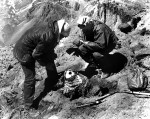
When a member of a mountaineering club first spotted what would prove to be the frozen mummy of an Inca child 17,400 feet up Argentina’s Aconcagua Mountain in 1985, he mistook it for a patch of grass. The other climbers, knowing grass didn’t grow at that altitude, checked it out and found not vegetation, but black and yellow feathers on the headdress of a young boy who had been sacrificed on the mountain 500 years earlier. With only part of the mummy exposed by erosion, the climbers wisely left it alone and returned to the city of Mendoza at the foothills of the Andes where they alerted archaeologist Dr. Juan Schobinger to the find. Fifteen days later, Schobinger and a team of volunteer archaeologists climbed the mountain and carefully excavated the mummy bundle.

This was a milestone in the history of mountain archaeology because it’s extremely rare that the professionals get to excavate the find before the people who discover it. Folks just can’t resist having a dig, sometimes because they were only up there in the first place looking for ancient treasure, as in the case of the El Plomo Mummy found in the Chilean Andes in 1954, or because they thought it was a recent death and called the cops, as in the case of Otzi the Iceman or out of simple curiosity.
The Aconcagua Mountain region in northwest of Argentina was once part of Collasuyu, the southern-most province of the Inca Empire. It was in this empire that lasted less than 100 years from 1438 A.D. until the Spanish conquest in 1532 A.D. that mountain sacrifices reached their apogee. The Incas built shrines at the peak of the highest mountains — Aconcagua is the highest mountain in the world outside of Asia — and there practiced the ceremony of capacocha, the ritual sacrifice of children on occasions of great import like the death of an emperor or in the wake of a natural disaster. The children selected were the most beautiful and healthiest in the empire. They would be given narcotics and alcohol, taken to mountaintop shrines and either left to die of exposure or killed outright.

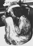
The Aconcagua child appears to have been killed by a blow to the head when he was about seven years old. The cold and dry of the Andean environment preserved his body, the two wool tunics he was wearing, the wool, hair and vegetable sandals on his feet, and multiple layers of cotton cloths and fiber cords wrapped around him, included the outermost wrap festooned with yellow parrot feathers. A total of 25 textiles were found in the bundle. Because the mummy was excavated with proper archaeological procedures, the exceptional preservation was maintained and additional objects were found in the fill underneath the child: six figurines, three human with clothes and feather accessories, and three stylized flames, one gold-plated and two made of Spondylus shell.

Preserved first by 500 years in a frigid and arid climate and then by careful archaeological practice — a replica is on display at the Archaeological Museum of Cuyo while the mummy itself is kept in a freezer at all time — the Aconcagua mummy was a rare pristine subject for interdisciplinary studies. Researchers found red dye, probably from the achiote tree, on his skin and a red liquid, also probably involving achiote, in his stomach. He’s been examined by medical doctors to determine cause of death, been subject to histological, microbiological, osteological, genetic and environmental analysis. He’s been X-rayed and CT scanned.
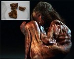
Now a team of geneticists has has mapped his mitochondrial genome, a first for any Native American mummy. In fact, not only is he the first Native American mummy whose full mitochondrial DNA has been successfully extracted, he’s the first for whom complete sequencing has even been attempted. Geneticist Antonio Salas from the University of Santiago de Compostela had high hopes that the Aconcagua mummy’s unique preservation conditions might have preserved enough of his DNA to be testable. A small sample of the child’s lung was tested — internal organs are less likely to be contaminated — and all 37 genes passed down from his mother were sequenced.

The boy’s pattern of genetic variations placed him in a population called C1b, a common lineage in Mesoamerica and the Andes that dates all the way back to the earliest Paleoindian settlements, more than 18,000 years ago. But C1b in itself is very diverse — as its members spread throughout Central and South America, smaller groups became isolated from one another and started developing their own particular genetic variations. As a result, C1b contains many genetically distinct subgroups. The Aconcagua boy’s genome didn’t fit into any of them. Instead, he belonged to a population of native South Americans that had never been identified. Salas and his team dubbed this genetic group C1bi, which they say likely arose in the Andes about 14,000 years ago. They detail their findings today in Scientific Reports.

When Salas combed through genetic databases, ancient and modern, he found just four more individuals who appear to belong to C1bi. Three are present-day people from Peru and Bolivia, whereas another sample comes from an individual from the ancient Wari Empire, which flourished from 600 to 1000 C.E. and predated the Inca in Peru. Clearly, C1bi is extremely rare today, but the fact that it has now popped up in two ancient DNA samples suggests that it could have been more common in the past, says Andrés Moreno-Estrada, a population geneticist who studies the Americas at Mexico’s National Laboratory of Genomics for Biodiversity in Irapuato and was not involved in the current work. If you sample just one or two individuals, “what are the chances that you pick the rare guy?” he says. “Most likely, you’re picking the common guy.”

It’s likely only so rare today because the Spanish and their diseases did such a thorough job of annihilating the native population. An estimated 90% were dead shortly after the conquest, and the rest interbred with Europeans, other Native American groups and Africans imported to the continent as slaves making the genes of modern Central and South Americans very distant indeed from the ones of their pre-conquest ancestors. The mummy’s DNA is frozen in time just as he was, providing us a rare window into past peoples. For instance, we know now that it took only 4,000 years for the earliest migrants to America to travel from Alaska to the Andes. The speed with which the continent was populated has been much debated, so this is very signficant new information.

Salas plans to go even further. He is working on mapping the complete nuclear genome of the Aconcagua mummy and when that’s done, he will turn his attentions to sequencing the genome of all the microorganisms in the boy’s digestive tract. That would lend new insight into the evolution of the microorganisms that live inside of us, helping us or actively trying to kill us.

You can read the full study here.

Tour the British Museum online with Google

The Google Cultural Institute (GCI) and the British Museum have worked together to make it possible people all over the world to enjoy the museum’s many offerings from the comfort of their homes. So far 4,654 objects and artworks have been made available for our perusal. Google’s Street View cameras have trundled through the museum’s vast halls, so you can virtually walk through them from the second basement to the fifth floor, the largest indoor space yet captured on Street View. They’ve even captured the outdoors so you have a stroll around the beautiful museum building itself.

The British Museum has an excellent website with more than 3.5 million objects in its searchable database, 920,000 of them with one of more photographs attached. Many of the pictures are very good, but even the largest of them are modestly sized (the usual caveat regarding my obsession with high resolution photography applies, of course) and there are a significant number that look dated or are in black and white. It’s a wonderful thing, therefore, to have fresh images of thousands of objects in ultra high resolution courtesy of Google’s gigapixel cameras.

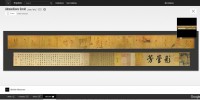
For example, the museum’s entry for the Admonitions Scroll, a Chinese painted silk handscroll more than 11 feet long from the 5th to the 8th century that depicts scenes from a 3rd century court poem, has 247 images. If you want to explore the details, you can go through the pictures one by one, but it’s tedious to have to go back and forth and the photo quality is less than satisfying. There are duplicates, old black and white shots and none of the pics I clicked on are more than 750 pixels wide. The scroll looks dingy, the painting dim.

Contrast that with the version on the Google Cultural Institute’s British Museum page. It’s a whole different viewing experience, like someone turned the light on in the room. You can see the whole thing in front of you at once. You can view the work in a depth of detail that you couldn’t possibly achieve in person unless your name is Steve Austin and they’ve made your other eye bionic too. You can see the weave of the silk, the individual hairs in the brushstrokes. It’s stupefying.

In addition to the objects from the permanent collection, there are also online versions of the museum’s temporary exhibitions, six of them right now with more to come. I’ve been pining to see Celtic Life in Iron Age Britain since it opened at the end of September. Gorgeous examples of Celtic metalwork, jewelry, objects of daily use and more are now viewable in detail online. It’s a curated online exhibit, not just a list of objects, arranged in a logical progression accompanied by explanatory notes. No Gundestrup Cauldron, though, sadly. It’s on the National Museum of Denmark’s GCI page, but not in gigapixel fun.

The collaboration between Google and the British Museum has also paved new territory for digital museum offerings. The Museum of the World microsite allows viewers to explore a timeline of artifacts divided into their continents of origin but then linked together by thematic connections. You swoop through time to a sparkly wind chimes sound effect while the objects load as polka dots, different colors for each part of the world — Africa, the Americas, Asia, Europe and Oceania. When you click on one of the dots, you see a small thumbnail and the title of the object and lines radiate outwards connecting it to other objects. If you want to learn more, click again. The detail view has a text explanation of the piece, an audio description introduced by a narrator and expanded on by a relevant curator. Click on the picture to see it in high resolution. On the right side under the audio there’s a map so you can see where the piece came from and then a few thumbnails of related works if you’d like to skip directly their detail views.

I found it thoroughly engrossing. I scrolled all the way to the back of the timeline to the oldest artifact in the museum: a 1.8 million-year-old basalt chopping tool from the Olduvai Gorge in Tanzania. It has only one connected piece — an 800,000-year-old Olduvai handaxe — by the related objects thumbnails take you far afield to an archaic Native American birdstone (1,000-1,500 B.C.) and an early 19th century Inuit ulu (a crescent-shaped knife). Once you get to the handaxe, the radiating lines proliferate.

You can browse by continent — just click the name and all the other dots will disappear, click it again for them to return — or by the themes listed in the menu to the right. Click the three squares in the upper left corner to cut the scrolling and jump to specific times.

Seriously this feature is the rabbit hole of all rabbit holes. I would strongly recommend you only click on the first link when you have a nice chunk of time available, because there is no way in hell you’ll be able to stop once you get started. This is ideal lost weekend material.

Two pieces of Roman sign found 122 years apart

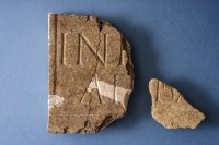
University of Reading archaeologists have discovered a fragment of a Roman inscription that matches a piece unearthed in 1891. Both pieces of the marble slab were excavated from the Roman town of Calleva Atrebatum next to the modern village of Silchester in Hampshire. The first and larger fragment was discovered by the Society of Antiquaries of London which excavated the entirety of the town within the Roman walls between 1890 and 1909. The piece had two truncated lines of text, “IN” on the top row, “AT” on the bottom. It was added to Reading Museum’s Silchester collection where it has remained for nearly a century and a quarter. The second fragment was found by the university team in 2013 during the excavation of Insula III, a block of the Roman town, just 10 meters (33 feet) away from the find spot of the first piece. The second piece has only one truncated row extant inscribed with the letters “BA.”

While just a small piece of a marble slab, it’s of considerable archaeological significance on its own because it’s likely a remnant of a plaque erected on a building to commemorate its construction or the deity to whom the structure was dedicated. Archaeologists believe the dedication was broken when the building was destroyed in the middle to late 1st century A.D., and very little material evidence of the destruction of an important building has been found in Britain.

The fragment was analyzed by Oxford University’s Dr. Roger Tomlin, an expert in Roman inscriptions. He’s the one who made the connection to the first fragment, finding they were both inscribed with the same style and size lettering on a slab of the same material — Purbeck Marble, a limestone native to Dorset that was extensively quarried in Roman Britain — and dimensions. Tomlin believes they are adjacent pieces, that the “BA” comes after the “AT” on the bottom row of the first fragment to spell out the word “At(e)ba(tum)” meaning “of the Atrebates,” the Gallic founders of the town of Calleva in the 1st century B.C.

Despite this amazing occurrence there could be more revelations to come. The name of the building is yet to be revealed but previous work at Silchester has connected the site to the infamous emperor Nero, as well as queen Boudica who led a famous rebellion against the Roman Empire.

Professor Fulford added: “We now know what the bottom line of the sign reads – however the top line remains a mystery. It’s a tantalising thought that this might link to Nero himself who is known to have commissioned major building projects in Silchester. Our work to uncover the origins of Silchester continues next year — perhaps a name could emerge. It’s unlikely — but this story goes to show that when it comes to archaeology, anything is possible.”

Calleva was a fortified settlement or oppidium that was the Atrebates’ seat of power. Numismatic evidence suggests that it was something of a mini-kingdom first ruled by Commius, a chieftain who at first had been Julius Caesar’s ally in the conquest of Gaul but who then turned on him and fought with Vercingetorix in his revolt against Rome in 52 B.C. According to Caesar’s legate Aulus Hirtius who wrote the eighth and last book of Caesar’s Gallic Wars, in 51 B.C. Commius finally struck a deal with Mark Anthony: he’d take his troublemaking ass out of Gaul on condition that he never had to see a Roman again. Anthony agreed and Commius crossed the Channel to Britain with a small group of followers.

It was that group which built the oppidium of Calleva. Coins have been found with Commius’ name and the names of his successors, so it seems Calleva was something of a city-state with him as its ruler. The Atrebates was added to Calleva’s name in a nod to its founders when the Iron Age oppidium was converted into a proper Roman town with streets on a grid pattern and solid stone walls after Claudius’ conquest of Britain in 43 A.D. The city was at a crossroads leading to important Roman urban centers, so it prospered and was known to have several large public buildings any one of which might have had a relevant inscription slab affixed to its walls.

Both inscription fragments will be on display in the University of Reading’s Museum of English Rural Life through November 27th.

Roman amphitheater found in Volterra

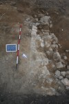
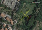
Last July, workers on a waterway restoration project near the Diana Gate on the north side of the ancient Etruscan city of Volterra stumbled on the remains of two walls 20 meters (66 feet) long. Archaeologists from the regional Superintendency were observing the works and took over when the ancient walls were found. Extrapolating from the shape and direction of the structures already unearthed, they dug test trenches in two locations that would have more walls if the building were, as they suspected, an amphitheater. Lo and behold, they found exactly what they expected to find: two more masonry walls each ten meters long with a marked elliptical curve.

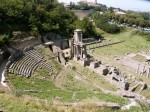
Calculating from the established curvature, the building is an oval 80 meters (262 feet) long by 60 meters (197 feet) wide, which is a pretty massive structure for people to forget ever existed. Volterra already has one Roman theater from the late 1st century BC, early 1st century AD that was discovered in 1950 by Volterran native son and historian Enrico Fiumi who was actually a trained economist, not an archaeologist, and whose excavation team was composed of patients from a local psychiatric hospital. The theater was partly dug into the side of a hill in Greek fashion and seated 3500. Some of the seats were found with the names of the most prominent local families, season ticket holders, if you will. A large section of the two-level skene (the building behind the stage) 50 feet high survives.

There is some mention in 15th and 16th century sources of an amphitheater in Volterra, but the writers were considered less than reliable on the details and thought to have been referring to the theater Fiumi discovered rather than a real amphitheater.

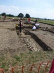
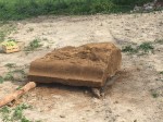
The discovery of the amphitheater caused a stir, but there was no funding to continue digging. The city had to go begging hat in hand to the local bank for sponsorship which thankfully they were able to secure. This September excavations resumed. Archaeologists found two rows of steps and additional architectural features were discovered: a large carved block that was part of the cryptoporticus roof and the base of an entrance arch. Like the ancient Etruscan city walls, these features are made of a porous sandstone native to the area called panchina which is soft and easy to work but hardens when exposed to the air.

“This amphitheater was quite large. Our survey dig revealed three orders of seats that could accommodate about 10,000 people. They were entertained by gladiators fights and wild beast baiting,” Elena Sorge, the archaeologist of the Tuscan Superintendency in charge of the excavation, told Discovery News.

By comparison, the Colosseum in Rome could seat more than 50,000 spectators during public games.

“The finding sheds a new light on the history of Volterra, which is most famous for its Etruscan legacy. It shows that during the emperor Augustus’s rule, it was an important Roman center,” she added.

Tuscany’s oldest continuously inhabited town, Volterra was an important urban center from the 6th century B.C. through the Renaissance, falling under the Roman sphere of influence in the 3rd century B.C. and under direct Roman control in the 1st century BC. Although there’s never been any doubt that it retained its cultural and political significance in the imperial era, the discovery of a second much larger public entertainment complex possibly from the 1st century A.D. indicates the city was more prominent and more populated than historians realized.

The goal of this fall’s excavation was very limited: analyze the remains to get a solid idea of what else is out there. With more data to work with, the archaeological team will be able to design a plan for a more thorough future excavation and a budget. Then they’ll have some figures to use when scrambling for more funding.

Giving Andrew Ellicott his due

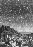
On November 12th, 1799, the first known record of a meteor shower in North America was written in the journal of a witness observing the Leonids from the deck of a ship in the Florida Keys. The occasion is marked in many an iteration of “This Day in History” entries, but in almost all of them there is a glaring error: the journal entry is attributed to Andrew Ellicott Douglass, an astronomer and founder of the modern science of dendrochronology who was born in 1867, 68 years after the Leonids put on such a spectacular show in the Keys.

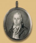
The real observer of the 1799 Leonids meteor shower was Andrew Ellicott, a surveyor who was in Florida on assignment from President George Washington to ascertain the official boundary line between the United States and Spanish territory as negotiated in the Treaty of San Lorenzo.

Here’s his journal entry from November 12th:

About two o’clock in the morning I was called up to see the shooting of the stars (as it is vulgarly termed), the phenomenon was grand and awful, the whole heavens appeared as if illuminated with sky rockets, flying in an infinity of directions, and I was in constant expectation of some of them falling on the vessel. They continued until put out by the light of the sun after daybreak. This phenomenon extended over a large portion of the West India islands and was observed as far north as St. Marys where it appeared as brilliant as with us.

The Leonids show up annually around this time and sprinkle light in the sky at the rate of about 20 meteors per hour, but every 33 years they put on a glorious light show with thousands of meteors per hour showering the sky. The 1833 storm was so strong at least 100,000 meteors, and maybe double that, streaked over North America in nine hours. The 1799 storm was just short of the peak of the cycle, but it was exceptionally strong nonetheless, which is why Ellicott hauled his cookies out of bed at two in the morning to see the show.

Although you might think the profession of surveyor would ensure Andrew Ellicott kept his eyes on the earth more than the skies, that his having made so meaningful a mark in the history of American astronomy was a fluke, in fact the line between heaven and earth, Horatio, was not so clearly demarcated. Jacques Cassini, son of astronomer Giovanni Cassini after whom the spaceprobe was named, was both astronomer and surveyor, having done the first triangulation of France and used the data to create the first scientifically rigorous map of France just a few decades before Ellicott saw the Leonids. Chemist Antoine Lavoisier, identifier of oxygen and hydrogen, also participated in surveys of France while watching the skies. Not coincidentally, Ellicott brought up Lavoisier’s theory that the atmosphere was composed of multiple elements right after seeing the Leonids. In the same November 12th journal entry, he wrote:

Many ingenious theories have been devised to account for those luminous and fiery meteors, but none of them are so satisfactory to my mind as the conjecture of that celebrated chemist M. Lavoisier, who supposes it probable that the terrestial atmosphere consists of several volumes, or strata of gaz or elastic vapour of different kinds, and that the lightest and most difficult to mix with the lower atmosphere will be elevated above it, and form a separate stratum or volume, which he supposes to be inflammable, and that it is at the point of contact between those strata that the aurora borealis, and other fiery meteors are produced.

Andrew Ellicott was renowned in his time for his great accuracy in surveying, determined in large part by his celestial observations. Born in 1754 to a large Quaker family of modest means in Pennsylvania, Ellicott fought in the Revolutionary War ultimately rising to the rank of major. After the war he worked with James Madison and David Rittenhouse continuing the survey of the Mason-Dixon line that had been abandoned during the conflict. He turned out to be really good at it. In 1786 he was commissioned to survey the western border of Pennsylvania, a meridian that is still today known as the Ellicott Line.

In 1792 Secretary of State Thomas Jefferson appointed Ellicott to survey the boundaries of the federal Territory of Columbia, which would be renamed the District of Columbia nine years later. That same year he surveyed the land that would become the city of Washington, then forming the nucleus of the Territory rather than the entirety of it. He worked with Pierre Charles L’Enfant on the plan of the city until L’Enfant pissed off the Commissioners overseeing the project enough to get the boot. Ellicott’s revised plan of Washington (which L’Enfant strenuously opposed) became the basis on which the capital was constructed.

In 1796 George Washington gave him the biggest assignment yet: surveying the border between Spanish North America and the United States. He spent four years travelling the Ohio and Mississippi rivers, the Gulf Coast and into Florida, deploying impressive diplomacy and patience in his dealings with Spanish commissioners, and recording everything in his journal. Another one of his boundaries that is still called Ellicott’s Line remains today the border between Alabama and Florida.

After that bear of a job was done, he moved to Lancaster, Pennsylvania where, among other things, he taught Meriwether Lewis how to survey in preparation for his great expedition to the Pacific with William Clark. In 1813 he took a job as Professor of Mathematics at the Military Academy at West Point. His last survey was in 1817 when he helped establish the western border between Canada and the United States as defined in the Treaty of Ghent. Andrew Ellicott died of a stroke on August 28th, 1820.

The term surveyor appears nowhere in his obituary printed in the New York Evening Post of August 29th. His great professional gifts belong to the field of “practical Astronomy” in which he was “pre-eminent, both in the expert use of Instruments, and the accuracy of his calculations, which were the results of his observations. The reputation which he gained for those rare and peculiar acquirements, was evinced by the number and frequency of his appointments, both by individual states and the United States, for the purpose of adjusting such boundary lines as depended on the most nice Astronomical observations.”

The obit concludes:

The Geography of our country, in particular, is indebted to him for many interesting details, and descriptions of its unfrequented parts, as well as for the most accurate adjustment of the relative situation of particular places. By his death, science is deprived of a devoted admirer — the Military Academy of one of its best friends and most distinguished Professors — society of a benevolent & useful member, and his family of a tender husband and a kind and affectionate parent.

We should all wish for such a glowing and meaningful final assessment.

What a pity, then, that the record of this great man has been erroneously subsumed into the life of another. I suspect the error originated with History.com and then spread around in the usual pattern of Internet epidemiology. I have emailed the site to let them know of the mistake, but I’m afraid there’s no putting the toothpaste back in the tube. Over much of the web, Andrew Ellicott will be denied his seminal astronomical observation, his rich contributions to the history and geography of the United States and even his very name while Andrew Ellicott Douglass, who has many genuine accomplishments worthy of This Day in History lists, will be taken out of his time and saddled with posthumous plagiarism of his own great-grandfather.

Yes, the name is not a coincidence or a distant tribute. Andrew Ellicott’s daughter Anne married David B. Douglass and they had a son named Malcolm. Malcolm Douglass and his wife Sarah Hale named one of their sons Andrew Ellicott after his illustrious great-grandfather.