Longhouse, Anglo-Saxon coin found at destroyed Pictish fort

Burghead Fort near the town of Lossiemouth in Moray, northeastern Scotland, was a major power center in the early Pictish kingdom of Fortriu. Between 6th and 9th centuries, the promontory fort at the site of the modern town of Burghead dominated the region. It was the largest of its time, three times larger than any other fort in Scotland. It is also the oldest known Pictish fort.

Its true origin and great historical significance wasn’t understood in the early 19th century. The fort was believed to be Roman, “the Ultima Ptoroton of Richard of Cirencester and Alta Castra of Ptolemy,” as Major-General William Roy labelled it in his drawing of the floor plan and sections of what was left of the fort in 1793. You might think that its purported Roman origin and association with the 2nd century writer Ptolemy who was believed to have described it in his Geography would be sufficient to ensure some degree of preservation, but you would be wrong. More than half of the fort’s surviving remains were destroyed when the town of Burghead was built between 1805 and 1809.

Burghead Bull, British Museum. Photo by Ealdgyth.
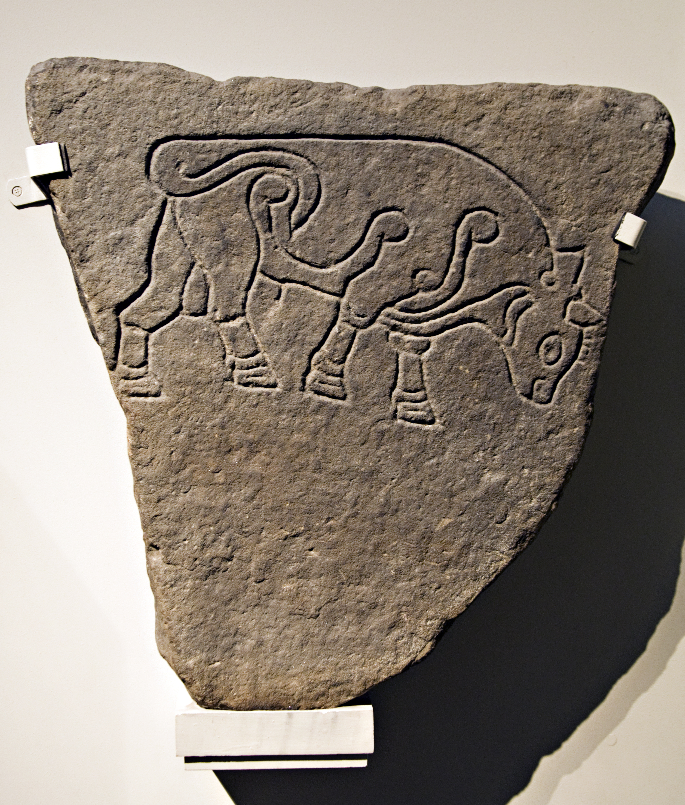
The orgy of destruction was entirely undeterred by the exceptional discovery of as many as 30 symbol stones engraved with realistic line art of bulls. Now known to be rare Pictish stones, most of them were casually reused as construction materials in the quay wall of the new harbour and are considered lost. Today only six of the Burghead Bulls survive, two in the Burghead visitor centre, the rest in the Elgin Museum, the National Museum of Scotland and the British Museum. All that’s left of the Pictish fort above ground are some lengths of the earth and rubble inner ramparts and a snippet of one of the outer ramparts on the southern side. A subterranean ritual well in a rock-cut chamber discovered during utilities work in 1809 is the most intact remnant of the fort.

Archaeological digs at Burghead began in the late 19th century (less than a hundred years from “who cares?” obliteration to desperately seeking antiquity). They usually focused on the perimeter of the structure — the inner and outer ramparts, the defensive wall — and while the occasional artifact was found, the fort was generally considered to have been gutted beyond recovery by the construction of the town and harbour.

University of Aberdeen archaeologists have been excavating the site since 2015 and this season has seen remarkable discoveries: evidence of a Pictish longhouse and a late 9th century Anglo-Saxon coin of Alfred the Great. Pictish architectural remains are rare and there are major lacunae in our understanding of Pictish buildings. The longhouse gives archaeologists a unique opportunity to study the Picts’ living spaces within a great fort. The coin not only helped establish the dates for the occupation of the longhouse, but it is from a key transitional period when Viking raiders began savaging Pictish territories and would ultimately bring about the demise of Pictish kingdoms.

Dr Gordon Noble, Head of Archaeology at the University of Aberdeen, said: “The assumption has always been that there was nothing left at Burghead; that it was all trashed in the 19th century but nobody’s really looked at the interior to see if there’s anything that survives inside the fort.

“But beneath the 19th century debris, we have started to find significant Pictish remains. We appear to have found a Pictish longhouse. This is important because Burghead is likely to have been one of the key royal centres of Northern Pictland and understanding the nature of settlement within the fort is key to understanding how power was materialised within these important fortified sites.

“There is a lovely stone-built hearth in one end of the building and the Anglo-Saxon coin shows the building dates towards the end of the use of the fort based on previous dating. The coin is also interesting as it shows that the fort occupants were able to tap into long-distance trade networks. The coin is also pierced, perhaps for wearing; it shows that the occupants of the fort in this non-monetary economy literally wore their wealth.

“Overall these findings suggest that there is still valuable information that can be recovered from Burghead which would tell us more about this society at a significant time for northern Scotland – just as Norse settlers were consolidating their power in Shetland and Orkney and launching attacks on mainland Scotland.”

New imaging approach reveals hidden text from two eras

In the Middle Ages, old manuscripts were recycled for their valuable vellum and parchment pages. The writing was washed or scrubbed off and the leaves filling with new content. Because so many ancient works have been lost, scholars have for centuries attempted to recover the original texts from these medieval palimpsests, often using caustic materials that damaged the pages in the long term. Nowadays researchers have much better options thanks largely to a panoply of imaging technologies that have been a godsend to the study of palimpsests, revealing erased and overwritten text that cannot be seen with the naked eye. Synchrotron imaging is better than Superman because it can see through lead boxes.

Some of the recycled parchments pose greater challenges than others. With the introduction of the printing press to Europe in the 15th century, the demand for bookmaking materials soared. Not only were medieval manuscripts cannibalized for their pages, but the bindings were reused to bind newly printed books. This was a common practice well into the 18th century, so there are a lot of old printed books out there with fragments of medieval and ancient texts hidden in the binding. Scholars knew there might be literary treasures in there, but were stumped by the difficulty of accessing and reading binding materials.

Now researchers at Northwestern University have made a breakthrough. It was a book from the university library’s collection that inspired the new approach. It’s an edition of the Works and Days by the Greek poet Hesiod that was printed in Venice in 1537. Northwestern acquired it in 1870 and out of the 30 known surviving copies of the edition, this is the only one that still has its original slotted parchment binding, a widely used technique in Venice from 1490 to 1670 in which slots were cut into the binding parchment to match the shape of the book spine.

Slotted parchment bindings often used recycled parchments. The ink was usually removed for aesthetic purposes, to make the outside surface of the parchment a uniform color. In this particular book, the ink on the interior parchment surface was not removed. Iron gall ink is acidic and over time, speeds up the oxidation and decay of the parchment.

The Northwestern librarians noticed the slotted parchment binding in the Hesiod and realized its significance. They also saw the faintest hint of text on the book board. Researchers from the Northwestern University-Art Institute of Chicago Center for Scientific Studies (NU-ACCESS) examined the binding in greater detail and found evidence that the writing on the book board had been removed, likely by the bookbinder, by washing or scraping. His efforts weren’t entirely effective, much to our advantage. Over time the gall ink that wasn’t removed had degraded the parchment and the writing began to re-emerge. NU-ACCESS researchers found two columns of text plus marginalia were very dimly visible through the parchment on the front and back covers of the book.

The writing wasn’t legible with the naked eye, so scientists Marc Walton and Emeline Pouyet turned to imaging, starting with visible light hyperspectral imaging. The writing became a little clearer, but it still couldn’t be read. X-ray fluorescence imaging gave the team new information about the chemical composition of the ink, but again, it wasn’t able to bring the ancient text out of hiding. They were going to need a bigger boat, to paraphrase Jaws, and the Cornell High Energy Synchrotron Source (CHESS) was that boat.

[T]he bright x-ray source and fast detection system allowed for a full imaging of the main text and marginalia comments in the entire bookbinding. When the researchers sent the more clearly imaged writing to [Northwestern history and religion professor Richard] Kieckhefer, he immediately recognized it as sixth-century Roman Law code [the Institutes Justinian], with interpretive notes referring to the Canon Law written in the margins.

Walton and Pouyet hypothesize that the parchment originally might have been used in a university setting where Roman Law was studied as a basis for understanding Canon Law, which was a common practice in the Middle Ages. The legal writing was then possibly covered and recycled because it was outdated as society had already struck down the Roman laws to implement church code.

It was an exciting find, but the NU-ACCESS team had greater ambitions. Synchrotrons aren’t exactly a dime a dozen, and most researchers don’t have access to the powerful (and expensive) equipment. Even if they do, rare old books in delicate condition can’t always be shipped to a synchrotron facility. For conservation reasons, they often can’t be shipped anywhere at all. Walton and Pouyet turned to Northwestern’s computer scientists to seek a cheaper, more readily available technology that would be able to read challenging palimpsest texts trapped in bookbindings.

“There is a vast number of wavelengths in the electromagnetic spectrum, and each wavelength has its advantages and disadvantages,” said [Aggelos] Katsaggelos, the Joseph Cummings Professor of Electrical Engineering and Computer Science. “Some of them can penetrate deeper into the specimen, some of them have better resolution, and so on.”

Using a machine-learning algorithm developed by his team, Katsaggelos discovered that not one imaging technique but a fusion of two would yield the best results. His team combined visible hyperspectral imaging, which includes wavelengths within the visible light spectrum to provide high spatial resolution, with x-ray fluorescence imaging, which provides high intensity resolution. The algorithm informed the researchers of the relative contribution of each modality to produce the best image.

“By combining the two modalities, we had the advantages of each,” Katsaggelos said. “We were able to read successfully what was inside the cover of the book.”

Katsaggelos’ data fusion image was so clear that it rivaled an image of the main text produced by the powerful x-ray beams at CHESS.

Walton and Pouyet plan to take this show on the road. They want to examine books in museums and other institutions using the combination of hyperspectral imaging and x-ray fluorescence to read hidden texts on pages and bindings. You can read the team’s publication of their results in the journal Analytica Chimica Acta here.

Oldest part of Charlemagne’s canal is even older, dig finds

The Fossa Carolina (Karlsgraben in modern German) is named after Charlemagne, King of the Franks, future Emperor of the Romans, who according to contemporary Carolingian sources commissioned its construction in 793. About two kilometers (1.2 miles) long, the canal was meant to link the Swabian Rezat river in Treuchtlingen to the Altmühl river in Weissenburg, Bavaria. The Rezat is in the Rhine basin and the Altmühl is a tributary of the Danube, so the ultimate idea behind the canal was creating a navigable water route that would allow easy boat travel between the Rhine and the Danube.

Whether it was a practicable solution in real life was a whole other ball of wax. According to the Revised Royal Frankish Annals, Charlemagne was “persuaded by self-styled experts that one could travel most conveniently from the Danube into the Rhine if a navigable canal was built between the rivers Rezat and Altmühl.” Reliable canal-linked fluvial transport was immensely important to Charlemagne in 793. He had been forced to end his 791 campaign against the Avars south of the Danube when his cavalry was stricken by the Eastern equine encephalitis (EEE) virus. The deadly mosquito-borne illness killed 90% of Charlemagne’s horses and other equines — war steeds, travel mounts, pack animals — in a matter of days. The few equines that survived a bout of EEE would have been severely disabled, suffering from brain damage and neurological symptoms that made it impossible for them to perform their usual duties of combat and transportation.

This was a logistical headache of brain-shattering proportions. Without horses and mules, the army’s supplies, weapons, armour and assorted gear had to be carried by people, at least some of it by horseless cavalrymen, to the Danube where it was loaded on boats. Charlemagne’s forces were so hobbled by the mass death of its equines that he wasn’t able to go on campaign for two years, and Charlemagne fought every year of his kingship, missing only four in total.

If the canal worked as planned, fluvial transportation — faster, cheaper and not subject to epidemics — would make it possible for Charlemagne to get back to his military campaigns against the Avars and rebellious Saxons, a war on two fronts that would have been enormously facilitated by a canal linking the Rhine and Danube. He would have been able to use large boats, not pack animals, to move equipment and supplies down the Danube in a new campaign against the Avars the next year. In addition, the actual digging of the canal required few horses, a big plus in a time of such equine scarcity.

It was such an important project that Charlemagne took up residence in Weissenburg in the fall of 793 to oversee construction of the canal. He personally saw to the hiring of a large team of builders. Under his direct supervision, the crew dug a moat 2,000 feet long and 300 feet wide. Again according to the Annals, canal constructed ended abortively, defeated by the marshy ground and constant rainfall which caused “what the workmen dug during the day, fell back in at night.” Other chroniclers claim the canal was in fact completed. Either way, Charlemagne’s attention was diverted to more pressing matters: fresh revolts in Saxony and attacks on Narbonne and Carcassonne by Umayyad Emir Hisham I of Córdoba.

Today there is little left of the most important infrastructure projects of the Middle Ages. There’s a water-filled moat about 350 meters (1148 feet) long in Treuchtlingen. Earthen embankments almost 4,000 feet long and more than 30 feet high also survive, created by the soil dug out of ground during the early construction of the canal. Over the past five years or so, archaeologists have discovered the northernmost section of the structure which is not visible above ground.

That section, which was fortunate enough to be forgotten and/or ignored for 1,200 years, has proven archaeologically invaluable. A team of researchers from German universities and the Bavarian State Office for the Protection of Monuments have discovered that the canal is older than the Royal Annals recorded. The question of when construction of the Fossa Carolina began has been a fraught one among historians for a century. The Alemannic Annals claim that canal construction began in 792, which would mean that Charlemagne’s stay in Weissenburg was a visit to an ongoing building site, not a new one he was personally supervising.

In 2013, timber pilings were discovered in the northernmost section that were dendrochronologically dated to the late summer or early fall of 793. A follow-up excavation in 2016 went even further, digging two trenches across two of the northern canal sections. The team unearthed numerous structural elements, including large oak pilings lining the canal walls that were in an excellent state of preservation thanks to the high groundwater level and a deposit of sediments immediately after construction.

The team was able to date more than two dozen timbers using dendrochronological analysis, an incredible bounty for high precision absolute dating. Tree ring analysis can pinpoint dates down to the year, sometimes even the month, and the youngest of the canal timbers tested date to the late spring or early summer (probably May) of 793. This was freshly cut wood. It hadn’t been stored for a few months before use in the canal.

This shows that the construction work at the Karlsgraben started several months earlier than was previously known. The description in the sources that the command for the construction of the canal has already taken place in 792 is thus significantly more likely. For the first time, the historical and political framework conditions of the decision to build the canal can now be clarified. The new dating also shows that Charlemagne visited a construction site, which had already begun several months earlier in the late summer/autumn of 793, and was by no means the “first spade”. […]

In the coming months, the new dates will be analyzed in detail and combined with numerous other results from the interdisciplinary research group. Due to the precise and different dates the researchers expect for the first time indications for the construction direction of individual channel sections and organizational details of the large construction site. New results are also to be expected regarding the completion or non-completion of individual construction sections.

Quilts made by men at war to go on display

Three years ago, St. Paul’s Cathedral in London restored and displayed a hand-made altar frontal that had been by intricately embroidered by 133 convalescing soldiers during World War I. Sewing was considered a highly effective form of occupational therapy for soldiers because it could be accomplished while seated, improved manual dexterity and mental focus. The notion of occupational therapy was birthed in the crucible of World War I which left so many men physically and psychologically disabled, but it was a new name for an old practice.

Soldiers and sailors have been stitching masterpieces of the sewing crafts for hundreds of years. It was a longstanding tradition that during lulls in fighting, while prisoners of war or over extended hospital visits, they would hand-stitch quilts, wool work seascapes and embroider their own uniforms. Sailors maintained ships’ sails as part of their duties and therefore had basic sewing skills. Soldiers didn’t have the same job requirement, so if they knew how to sew it was either fortuitous or professional; i.e., they had been tailors in civilian life and were often employed as regimental tailors in the military.

Some of the earliest surviving examples were made in the 18th century using the intarsia technique in which fabric pieces are cut in precise shapes and sewn together so that no seams show. These types of quilts are so difficult to produce that it’s likely they were created by professionals. The imagery is often related to the wars being fought and national identity — comrades, the fatherland, traditional folk tales, etc. The quilts produced in wartime by military men of all levels of stitchcraft experience often used uniform pieces, blankets and random snippets of whatever other textiles they could get their hands on to create geometric designs of dazzling intricacy.

The American Folk Art Museum in New York is putting on the first US exhibition of quilts made by fighting men in wartime from uniform fabric. Most of the quilts on view in the War and Pieced exhibition come from the private collection of Australian quilt expert, historian Dr. Annette Gero. Others are on loan from public and private collections. Many of them have never been publically displayed before.

Immigrant tailors, such as Hungarian-born Michael Zumpf, introduced the intarsia technique into Great Britain. Two masterworks, exhibited to great acclaim in London during the late nineteenth century, feature minutely detailed representations of British military and political leaders, and members of the House of Commons. These elaborate pictorial panels were made using popular etchings of those subjects as templates.

Perhaps the best-known quilts that were made by soldiers and regimental tailors are the complex geometrics fashioned from felted military uniforms. Hand-stitched by nineteenth-century British soldiers, sailors, and regimental tailors during periods of conflict in the Crimea, South Africa, and India, some of these mosaic-like quilts contain as many as twenty-five thousand pieces of fabric. They were once called “convalescent quilts,” it was believed they were made as occupational therapy by wounded soldiers recovering in hospitals. Quilts pieced in simple geometric patterns may indeed have been made in such circumstances, but it is now recognized that the most elaborate quilts were most probably stitched by tailors and soldiers to pass the time and stay out of mischief, to give as gifts to loved ones at home, or were made upon a soldier’s return.

“In the context of war, quiltmaking becomes a life-affirming testament to bravery, loyalty, and an act of redemption for darker human impulses enacted under dire circumstances,” says Stacy C. Hollander[, chief curator of the American Folk Art Museum]. “Memory and experience are fragmented and brilliantly reconstructed through tiny bits of cloth. The uniforms, associated with the best and worst of humanity, are thus transformed into testaments of sanity and beauty, even as the highly organized geometry grants the soldier an illusion of control over the predations of war in which he has both participated and witnessed.”

War and Pieced will run at the American Folk Art Museum from September 6th, 2017, through January 7th, 2018. Next year the exhibition will travel to the International Quilt Study Center & Museum at the University of Lincoln-Nebraska where it will run from the May 25th through September 16th, 2018.

But enough of my yakking. This post is all about the cornucopia of quiltly goodness and there’s so much more bounty to enjoy I had to put it after the jump to keep load times from going insane.

(more…)

Smiley found painted on 3,700-year-old pitcher

A team of Turkish and Italian archaeologists have discovered what may be the first known smiley face in the ancient city of Karkemish in Turkey’s southeastern province of Gaziantep near the border with Syria. The terminally cheery curved line topped by two dots was painted on the side of pitcher around 3,700 years ago.

“The smiling face is undoubtedly there (there are no other traces of painting on the flask) and has no parallels in ancient ceramic art of the area,” [excavation leader Dr. Nicolo Marchetti of Bologna University] said. […]

The unusual pitcher in question was originally off-white in colour and features a short thin neck, wide body and small handle. Found in a burial chamber, it was used for a sweet sherbet-like drink, and dates back to 1,700 BC.

Archaeologists only realised the smile was there when the pot was taken to a lab for restoration work, Turkish news agency Anadolou reported.

Occupied from the 6th millennium B.C. until it was abandoned in the late Middle Ages, the remains of Karkemish were first discovered and excavated in the late 19th century. Some illustrious figures — T.E. Lawrence, Leonard Woolley, Gertrude Bell — participated in later digs before and after World I. Even with this long history of archaeological exploration, the site still had much to reveal. The joint Turkey and Italian team has been excavating Karkemish every year since 2011. The smiley pitcher was found this season, which began on May 2nd, and it was not the only important discovery.

The team also unearthed 250 bullae, clay tokens impressed with seals that would be attached to legal and commercial documents as proof identity and authenticity. The seals were found in the late Bronze Age layer and date to the Hittite Empire in the 13th century B.C. when Karkemish was the seat of the Hittite viceroy who controlled the entire region. Among the 250 bullae are the seals of some of the highest ranking individuals in the Hittite administration of the city, most notably that of Taya or Tahe, prince and “charioteer of the goddess Kubaba.” Researchers are excited by the great number of bullae recovered because they hope the seals will reveal new information about the people, trade and administrative systems of Karkemish during its most prosperous period.

Another exceptional find made in the same area of the city is a large basalt relief of two rampant griffons. It was carved at the end of the 10th century B.C. during the reign of the Neo-Hittite king Katuwa who was better known for his construction and sculptural endeavors than his prowess on the battlefield. The griffon relief is believed to be one of a pair with a relief of a winged bull discovered during last year’s excavation. Archaeologists found significant architectural remains as well, including the remains of a massive fortress and a grain silo, both dating to the end of the Neo-Assyrian period, around 1100 B.C.

Seven season of digs will soon come to a culmination when the site is opened to the public for the first time next year. Karkemish is in a militarily sensitive area and access has long been restricted. The Turkish Minister of Culture and Tourism announced earlier this month that on May 12th, 2018, the site will open its doors as the Karkemish Ancient City Archaeological Park. The smiley jug will go on display at the nearby Gaziantep Museum of Archaeology.

There is a whole new sense of urgency and meaning behind the excavations and the upcoming archaeological park. On the Syrian side of the border, the civil war has taken an unbearably onerous toll on its rich ancient history. While some of the most precious and beautiful archaeological remains in the world have been brutalized by ISIS and other belligerents in this quagmire from hell, excavation and conservation of ancient material culture has continued undeterred just over the border in Turkey.