Temple of Venus and Roma reopens

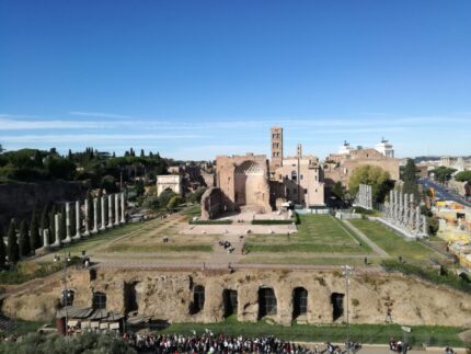
The remains of the Temple of Venus and Rome, the largest sacred building ever constructed in the Eternal City, have reopened to the public after a major restoration project funded by fashion house Maison Fendi.

The Temple of Venus and Rome was personally designed by Emperor Hadrian and constructed at his command between 121 and 137 A.D. on a high platform on the Velia hill overlooking the Colosseum. The colossus that gives the Flavian Amphitheater its name today stood on that site, originally placed there by Nero. Hadrian had it moved to a new location aside the Colosseum to make way for his massive new temple. It took 24 elephants to move the statue.

Hadrian’s innovative idea to celebrate the goddesses Venus Felix and Roma Aeterna was to build the two cellae (the sacred rooms where the statues of the goddesses sat and only the clergy were allowed) back-to-back instead of the traditional side-to-side configuration. Trajan’s famous architect Apollodorus of Damascus was not a fan, so naturally Hadrian had him killed.
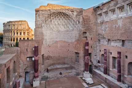
Maxentius ditched Hadrian’s cella design when he rebuilt the temple after it was devastated by fire in 307 A.D. He reconstructed it with two apses covered by coffered vault roofs made of stone instead of the original wood ceilings. He also added porphyry columns to the Proconnesian marble columns in the porticoes and the grey granite columns in the peristyle.

The temple was converted into an oratory dedicated to Saints Peter and Paul in the 8th century, but most of the immense structure was destroyed by an earthquake in the 9th century. The church of Santa Maria Nova, and later Santa Francesca Romana, rose from the ruins.

Today the remains left standing on the platform are from Maxentius’ reconstruction. The porphyry columns and marble inlay floors and walls were reassembled from fragments in the 1930s. There’s also a convent and the offices of the Archaeological Park of the Colosseum integrated into the site.

The Colosseum Park has put together a great video that explains the history (narration is in Italian but captions are bilingual in English and Italian) and virtually reconstructs the enormous temple, placing it in the context of the modern city.
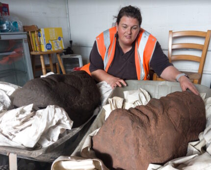
Monumental statue heads found at Carlisle Roman bathhouse

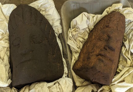
The excavation of the sumptuous Roman bathhouse at the Carlisle Cricket Club has unearthed two monumental statue heads believed to date to the early 3rd century. The sandstone heads are two feet high, three times bigger than life-sized. Extrapolating from the size of the heads, archaeologists believe the original statues must have been between 12 and 15 feet high. These are the first sculptures unearthed at the site.

The heads were discovered yesterday, just two days after the new dig season began by volunteers Carolyn Veit and Ruth Pearce. They were found at the edge of a cobbled Roman road. They appear to have been purposely left there, placed side-by-side on the cobbled surface of the road. They were covered in dark soil when the road fell into disuse in the 5th century.

Archaeologists believe they may have been rejected spolia (ancient building materials stripped and repurposed for later construction), left by the roadside by people looting one of the huge structures in the bathhouse complex for its building materials.

Artifacts like tiles branded with the IMP stamp and an inscription dedicated to Julia Domna underscore the connection between the bath complex and the emperor Septimius Severus who was there in 208 A.D. during his military campaign against the Caledonian tribes north of Hadrian’s Wall. One possibility is that the heads, one of which is female and the other male, may be representations of Septimius Severus and his wife Julia Domna. The female figure has thick, wavy plaits, a hairstyle Julia Domna was famous for throughout the empire. Another possibility is that the monumental statues represented deities.

Lead archaeologist Frank Giecco said they were “unique and priceless”. […]

“In 30 years of being an archaeologist I’ve never found a thing like this before.

“It’s just incredible for Carlisle. It just raises the status of this building.”

Mr Giecco said figures were not an unusual find in bathhouses “but sculptures of this size are really special”.

“You can probably count on one hand examples of this kind in Britain,” he said.

Ming Dynasty shipwrecks laden with porcelain, wood found in South China Sea

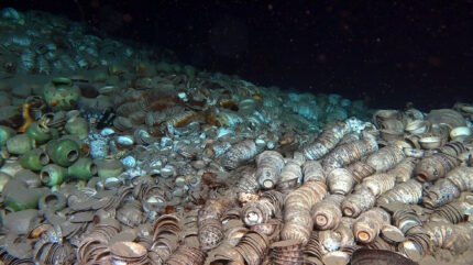
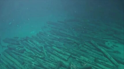
Two shipwrecks from the Ming Dynasty (1368-1644), one laden with thousands of pristine porcelain objects, the other with wood logs, have been discovered deep under the South China Sea. The shipwrecks were discovered last October on the northwest continental slope of the South China Sea off the coast of Hainan island at a depth of 1,500 meters (just under a mile).

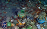
With the wreck of Ship No. 1, the remains of the ship itself are mostly obscured by tens of thousands of porcelain artifacts intended for export trade. The porcelain is so dense that there are stacked and nested vessels six feet deep covering 10,000 square meters (2.5 acres). Archaeologists estimate there are more than 100,000 individual pieces. Analysis of a few of the pieces suggest they were produced during the Zhentoku era (1506-1521).

Ship No. 2 was carrying raw wood. The timbers were uniform in size and carefully stacked. Initial analysis of the wood indicates the ship was a Chinese importer bringing in wood supplies from overseas in the Meiji-Koji era (1488-1505). They were likely intended for use in ship-building.

This is the first time a ship with export cargo and one with import cargo have been found in the same area. It is evidence of how well-established and widely-frequented in both directions sea routes were along the Maritime Silk Road. The two neighboring wrecks provide researchers a unique opportunity to study two-way traffic in the South China Sea 500 years ago.

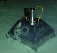
Underwater archaeology in such deep waters poses enormous logistical challenges. This month, the cultural heritage administration of Hainan Province launched a new investigation to map the shipwrecks using a state-of-the-art manned submersible and a new permanent surveying and mapping base point installed in the seabed at the wreck of the first ship. This marks a significant leap forward in deep-sea archaeology.

China’s scientific research vessel Tansuo 1, equipped with the submersible Shenhai Yongshi, or Deep Sea Warrior, took researchers underwater for the exploration on Saturday. Chen Chuanxu, a scientist at the Institute of Deep-sea Science and Engineering, said that another vessel, the Tansuo 2, equipped with the submersible Fendouzhe, or Striver, will join the mission.

Advanced technological approaches, including soft robotics inspired by bionics and material science, were employed during the operation to salvage some of the relics from the shipwreck sites. New methods of scanning, photography and monitoring were also used.

“Speaking of protection and real-time monitoring of such a large underwater site at a depth of 1,500 meters, we have no precedent in the world,” Chen said, adding that the researchers are currently trying to remotely monitor the site.

The investigation will take place over about a year. The first phase will be a thorough survey of the wrecks. The second will entail a scientific evaluation of the preservation conditions of the wrecks. The third and final phase will be determining how best to protect the wrecks going forward.

10th c. amulet with early Cyrillic inscription found in Bulgaria

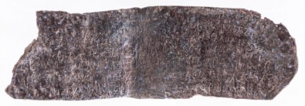
A lead plate amulet discovered in the medieval fortress of Balak Dere near the village of Huhla, in southern Bulgaria, bears one of the earliest known inscriptions in Cyrillic. The amulet was unearthed last autumn in a layer with artifacts dating to the first half of the 10th century. Epigraphic analysis of the inscription confirms the date based on the archaic style of lettering.

It was found folded in half and in dire need of cleaning. The inscription was not initially visible to the naked eye. The photographer documenting the find spotted the writing first, and only after an cleaning and conservation could researchers begin to decipher the inscriptions. Reflectance Transformation Imaging (RTΙ) photography was used to make out the hard-to-read lettering.

There are seven rows of text on the inside of the folded rectangular plate and four rows on the outside. They contain prayers for the protection of named individuals. The plate was worn as a pendant to protect the wearer.

It was believed that such apotropaic amulets protected their owner from the evil eye, magic spells and disease. Around 50-60 such 10th century artefacts found in Northeastern Bulgaria have so far been studied, but the find in Balak Dere is unique, with no equivalent so far, researchers say.

“The difference is that what we have here is a supplication, even the names of the supplicants are known – Nikola and Pavel,” [excavation leader] Ivaylo Kanev explains. “They are asking St. Dimitar to intercede with God on their behalf and protect them from such-and-such calamities, as, the authors say, and I will quote the last line which is very canonical and astonishing, because we have never seen anything like it before: “…wash his face with grace, exonerate the shame, heal, oh, Saint, because His is the glory, and the honour, and the state, now and forever, Amin!” Very well structured, like a canon, there are no simple wishes here. That is the other novelty.”

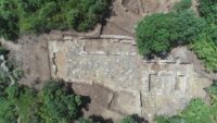
Recent excavations at the hilltop site have uncovered evidence that the fortress was in use off and on from the 4th until the early 13th centuries. It was part of a system of fortresses built in the middle of the 4th century to defend the imperial capital of Constantinople. It was burned down at the end of the 5th century but quickly rebuilt.

It was destroyed again by the Avars in the early 7th century and was only reoccupied in the 10th century when troops of Bulgarian Tsar Simeon I the Great (r. 893-927) used it during the king’s wars against the Byzantine Empire. What went around came around in the 12th century when the troops of Byzantine Emperor Alexios I Komnenos (r. 1081-1118) occupied the fortress. The site was permanently abandoned in the first quarter of the 13th century.

The archaeological layer the lead plate amulet was found in spurred archaeologists to compare the inscription to Cyrillic writing from Tsar Simeon’s rule. Cyrillic was developed in the 890s at the Preslav Literary School in the Bulgarian capital of Pliska. The earliest dateable Cyrillic inscriptions on the record have been found there, with the earliest dating to 921. Simeon’s Bulgarian troops were at Balak Dere between 916 and 927, so this amulet may be THE earliest known Cyrillic inscription, not just one of the earliest.

2,700-year-old petroglyphs found on mossy rock in Sweden

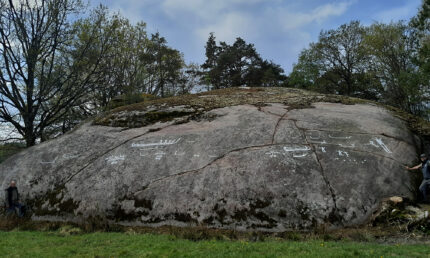
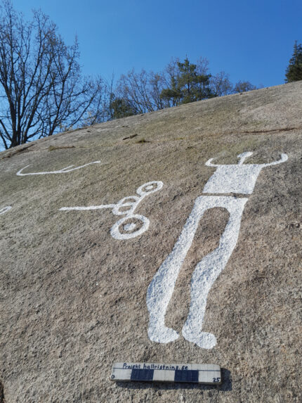
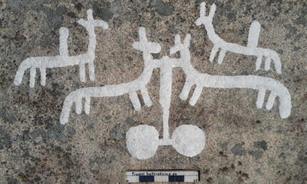
Archaeologists have discovered a group of late Nordic Bronze Age petroglyphs hidden under a thick covering of moss in Bohuslän, southwestern Sweden. Forty figures, including 13 ships, nine horses, seven people and four chariots, cover an area fifty feet wide. It is the largest find of Bronze Age petroglyphs made so far in this century.

The rock was found on pastureland at a farm in the parish of Kville. When the figures were carved 2,700 years ago, the site, now 40 feet above sea level, was on the coastline. The rock was on an island and was partially submerged. The artists must have stood on boats to carve the artwork just above the waterline. The petroglyphs would have been highly visible in the seascape.

Some of the individual carvings are notably large. One of the ships is 6.5 feet wide; one of the humans is more than three feet tall. The engravings are deeply carved, exposing the white rock and standing in sharp contrast to the grey of the background, long-since darkened to a charcoal color by the cyanobacteria in the sea water.

Archaeologists from the Foundation for Documentation of Bohuslän Rock Carvings spotted a small piece of one of the ships peering out from the thick moss cover. When they removed the moss, they found a wealth of other petroglyphs carved into the nearly vertical surface of the stone. That’s an unusual alignment; usually the petroglyphs were engraved on flatter slabs that the artists could easily climb and stand on to carve.

This orientation gave archaeologists the ability to date the work with more precision than is usually possible. Because we know what sea level was at different periods, the rock art cannot have been carved before the 8th century B.C. when the stone emerged from the lowering waters. If it was carved after the 7th century, the artists would have had to use ladders to reach the rock face, and carving in straight lines for meters while on a ladder/platform is prohibitively challenging, if not impossible.

The province of Bohuslän on the rocky coast of southwestern Sweden consists of more than 8000 islands and islets. More than 1,500 rock art sites, the largest concentration of Bronze Age rock art in Scandinavia, have been documented there, and that is a fraction of the estimated total. Historically most of the focus has been on the art found on the more grand cliffs and outcroppings as documenting all of the rock carvings was deemed an impossible goal. The Foundation for Documentation of Bohuslän Rock Carvings has been working for more than 20 years to seek out previously unknown petroglyphs and to document them in a systematic way.