The April issue of National Geographic is marking the centennial month of the sinking of the Titanic with exceptional new pictures of the wreck composed from thousands of side-scan, sonar and high definition images taken by the 2010 expedition.
“This is a game-changer,” says National Oceanic and Atmospheric Administration (NOAA) archaeologist James Delgado, the expedition’s chief scientist. “In the past, trying to understand Titanic was like trying to understand Manhattan at midnight in a rainstorm—with a flashlight. Now we have a site that can be understood and measured, with definite things to tell us. In years to come this historic map may give voice to those people who were silenced, seemingly forever, when the cold water closed over them.”
The composite pictures are beautiful and eerie and detailed almost beyond belief. Earlier high definition pictures and video from the site were narrowly focused, bounded by the limits of visibility 2 miles below the surface of the North Atlantic and by the camera lens. The composites put all those little keyhole shots together.
Pictures and captions courtesy of National Geographic.

COPYRIGHT© 2012 RMS TITANIC, INC; Produced by AIVL, Woods Hole Oceanographic Institute. The first complete views of the legendary wreck. Ethereal views of Titanic’s bow offer a comprehensiveness of detail never seen before. The optical mosaics each consist of 1,500 high-resolution images rectified using sonar data.

COPYRIGHT© 2012 RMS TITANIC, INC; Produced by AIVL, WHOI. As the starboard profile shows, the Titanic buckled as it plowed nose-first into the seabed, leaving the forward hull buried deep in mud—obscuring, possibly forever, the mortal wounds inflicted by the iceberg.

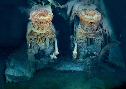
COPYRIGHT© 2012 RMS TITANIC, INC; Produced by AIVL, WHOI. Two of Titanic’s engines lie exposed in a gaping cross section of the stern. Draped in “rusticles”—orange stalactites created by iron-eating bacteria—these massive structures, four stories tall, once powered the largest moving man-made object on Earth.
You also see parts of the ship scattered over the debris field which have never been seen before since earlier images focused on the large parts, particularly the bow:

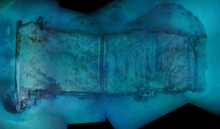
COPYRIGHT© 2012 RMS TITANIC, INC; Produced by AIVL, WHOI. Two sections of Titanic’s double-bottom hull ripped off the stern as it sank. Their hydrodynamic shape may account for their landing well to the east of the rest of the debris. How a collapsed pile of decking landed nearby remains a mystery.
The April issue of National Geographic also has a supersweet poster (aren’t all NG posters supersweet?) of Titanic’s demise, reconstructed based on the new data recovered from the ocean floor. The National Geographic website has an excellent companion layout with a featured article that in addition to covering the recent expedition also covers RMS Titanic, Inc.’s change in approach over the years from a salvage operation dedicated to collecting artifacts for display and sale to a curatorial emphasis on documenting and conserving the wreck.
There’s also a neat gallery comparing images of the wreck to pictures from Titanic’s twin RMS Olympic, an interactive wreck map with information on salient features, and zoomable images of the wreck. Don’t miss the zoomable pic of the stern in profile. It looks like it was torn apart and partially eaten by Krakens.