George III’s huge map collection digitized

The British Library has begun a massive project to digitize all of King George III’s 50,000-piece map collection. George III was an avid collector, not just of things he personally loved but in true Enlightenment style, of things he thought would be of intellectual value to the nation. He added significantly to the royal art collection, dedicated a lifetime to collecting books that he made available to all scholars (not even John Adams was barred) and put together an extensive collection of mathematical and scientific instruments.
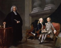
Maps and topography were a genuine passion of the king’s and had been since he was a young boy. There’s a well-known portrait of George III when he was Prince of Wales with his younger brother Edward Augustus at their lessons with tutor Francis Ayscough. Next to the future king is a globe, a book with an imprint of the Prince of Wales’ feathers leaning against it. It’s a prescient image. Once he was king, his love of geography became professionally important as well, and there are accounts of his dedication to learning every detail about the topographical details of ports, fortresses and cities.

While British monarchs before him had squirreled away maps and atlases in various nooks of royal palaces, it was George III who brought them all together into a single collection that he then added to extensively. He had agents scouring Europe to acquire important pieces and even whole collections. He incorporated all gifts of maps and atlases to the monarch from his subjects into the collection. He even straight-up stole from royal engineers, military and colonial mapmakers who sent drawings, prints and watercolors for his inspection. Late 18th century land surveys done by British military surveyors for the American Board of Trade, for example, never made it to their commissioner. George was so enthralled with the series, which included a map of the Florida coast more than 22 feet long, that he just kept them all, bless his heart, and added them to the ever-expanding collection kept in a room next to his sleeping chamber in Buckingham House, then not yet an official palace.
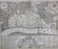
By the time of King George III’s death in 1820, the Topographical Collection included 60,000 drawings, watercolors, manuscripts, prints, letters, reports and atlases dating from 1500 to the then-present. Half of the material covers Britain and its colonies (or former colonies after the American Revolution) while about 30% covers European countries like Italy and France that were popular Grand Tour destinations. The map collection was gifted to the nation by his son, George IV, along with the late king’s book collection. (He kept all the military maps for national security purposes.)

Originally dispatched to the British Museum, George III’s Topographical Collection was moved to the British Library. Despite its royal pedigree and historical significance, the full collection was never thoroughly catalogued. The British Library moved to remedy that in 2013, raising funds from private donors to catalogue, conserve and digitize George’s beloved maps. It’s a massive job, expensive in time and money, and the library still doesn’t have the funds needed to complete it. They’ve started piecemeal using the donations they have. So far they have conserved, catalogued and digitized all color views, the maps and atlases of South and North America, China, Scotland, southwest England, Spain and 30% of London and southeast England. As of last month, about 25% of the collection has been digitized.
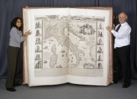
Right now the project is working on the gem of the collection, the gigantic The Klencke Atlas which was the world’s largest atlas until the publication of the Earth Platinum atlas in 2012 which is new so as far as I’m concerned it doesn’t count. At 5’9″ by 6’3″ when open, the atlas is literally man-sized. It wasn’t actually one of George III’s acquisitions. The atlas was given to King Charles II, a known map aficionado, in 1660 by a group of Dutch merchants led by sugar merchant Johannes Klencke as a gift celebrating the king’s restoration to the throne. On its huge pages are 41 walls maps of Europe, Britain, Latin America, Asia and the Middle East. Charles II liked it so much he put it with his most prized objects in his cabinet of curiosities at Whitehall Palace.

The Klencke Atlas has long been a favorite with British Library staff — there are photographs of curators being dwarfed by it going back to the 19th century — but photographing the giant pages themselves in any kind of quality was all but impossible until recently. The technology now makes it possible to capture high resolution images of sections of every page and digitally knit them together into a single image. This will give viewers the chance to the see both the big picture, as it were, of each page and to zoom in on the tiny details — names, labels, etc. — that would have been too blurred out to read a decade ago.
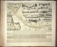
The digitization of the Klencke Atlas and 80 other pieces was funded by a donation from rare book seller Daniel Crouch who has a lovely outlook on the matter.

Crouch admits that it is “an unsexy cause — it’s not like naming a gallery. It is the digitisation of a lot of old stuff.” He stresses that, although “it doesn’t sound important or life-saving, it actually is. It’s the kind of resource that will be used in years to come and will make the holdings of the British Library accessible to all.”

The digitization of the Klencke Atlas is scheduled to be complete by the end of 2016. Meanwhile, there’s the other 75% of the Topographical Collection that still needs love and attention before we can spend entire weekends on a nerd bender of George III’s maps. The British Library needs another £500,000 ($730,000) to finish the job. To donate to the digitization project, go here and select “Unlock London maps” from the dropdown (it should be selected by default) once you’ve chosen an amount and clicked through.
18th c. scuttled ship found on Potomac riverfront

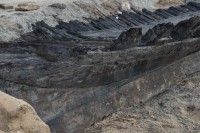
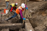
Archaeologists overseeing construction on the Potomac riverfront in Alexandria, Virginia, have found the well-preserved remains of a ship that was scuttled in the late 18th century. The 50-foot section of the port side of the hull, an estimated 1/3 of the original length of the ship, including some of the keel, frame, bow stem, stern and exterior boards and interior flooring, survived the centuries thanks to the waterlogged soil which kept oxygen and microbes from devouring the wood.

The ship is being thoroughly documented in situ via 3D laser scanning, high resolution photography and precise measurement. Each layer of the wood — archaeologists believe there are at least three — will be scanned and photographed before removal. An expert will examine the remains to identify the wood and date it precisely with dendrochronological analysis. The dismantled ship parts will be kept under water for preservation purposes — a lab has yet to be found that can accommodate it — while the city decides seeks funding for long-term conservation, study and possible display.

While we await an exact date based on when the trees were cut, historians have already pinpointed a tight date range by documentary study. The site was originally located on a bluff overlooking a Potomac cove. That cove was filled in to extend the property in the late 1700s. Historical maps showing how the shoreline changed in the second half of the 18th century provide a possible window for when the ship was buried of between 1775 and 1798.

The frame sections were placed very close together, an indication that the ship was built to carry heavy loads. It was likely a coast-hugging vessel rather than ocean-going, and while archaeologists tentatively believe it was a merchant ship, they cannot yet rule out that it had a military use. There is evidence of deliberate chopping of the hull, probably with a broad axe. This may have been done during the filling in the cove as the ship was chopped up to fit into the given space.

The site of the future Indigo Hotel at 220 S. Union Street is part of a major redevelopment project of Alexandria’s historic waterfront. The ship is the second significant historical find in the one-block site. In September archaeologists unearthed the remains of a warehouse built in 1755 that is thought to be the first public building erected in Alexandria which was only six years old at the time. Historical records of a June 18th, 1755, meeting of the Trustees of Alexandria document their order that a warehouse “One hundred feet long twenty four feet wide thirteen feet Pitch’d To be three Divisions double strided” be constructed, and archaeologists found almost exactly that: the outline of a wooden building 90 feet long and 24 feet wide. The 10 missing feet were destroyed by later construction on the site.

With the stone foundations, large beam framing and even sections of the floor and interior walls surviving, the warehouse remains give historians the unique chance to explore mid-18th century construction elements like the extensive use of mortise and tenon joints even in the studs and beams, and to study the city’s very early commercial history. It was dismantled and sent to the Maryland Archaeological Conservation Lab in St. Leonard to be preserved in its tanks.

Unlike the warehouse whose location was recorded in the Trustees meeting, the discovery ship came as a complete surprise to excavators. There are no surviving records known that document its scuttling and installation, nor are any expected to be found.

“It’s very rare. This almost never happens,” said Dan Baicy, the hard-hatted field director for Thunderbird Archeology, the firm watching for historic evidence during construction. “In 15 years that I’ve done this work, I’ve never run into this kind of preservation in an urban environment where there’s so much disturbance.”

Skeleton found under Scottish school playground may have been a pirate

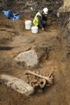
An excavation at Edinburgh’s Victoria Primary School last year unearthed the skeletal remains of what may have been a 16th century pirate.

Founded in the 1840s, Victoria Primary School is the oldest working elementary school in Edinburgh and is housed in a historic building in the neighborhood of Newhaven which was once a thriving fishing village with a harbour on the Firth of Forth. In the early 1500s, King James IV, visions of a great Scottish navy dancing in his head, established a deep-water port with a dock for the construction of large warships in Newhaven. The first ship constructed at the Newhaven port was the Great Michael, the largest ship in the world when it launched in 1511 with twice the displacement of its exact contemporary and King Henry VIII’s pride and joy, the Mary Rose.

When the City of Edinburgh Council decided to build an addition to the primary school building, AOC Archaeology was contracted to do a thorough archaeological survey before construction. With the school near the present harbour and practically on top of the original one, archaeologists expected to find the remains of structures from the old harbour and the shipbuilding concerns that once proliferated there. Instead they found skeletal remains in very poor condition.

Because of its condition and because shards of 4,000-year-old Bronze Age pottery were unearthed alongside the skeleton, the archaeological team at first thought the remains were very ancient. Radiocarbon dating performed by AOC Archaeology revealed that in fact the remains date to the 16th century or 17th century. The date, location and condition of the remains suggest this man, who was about 50 years old at the time of death, did not die a peaceful death and go to a respectful repose.

At that time, there was a gibbet on the Newhaven dockyards where pirates and others convicted of capital crimes would be hung for weeks until their bodies rotted away. Pirates were particularly popular candidates for the Newhaven gibbet because hanging their decaying bodies in plain view of the ships in the harbour was meant to be a deterrent to any other would-be scurvy dogs. Whatever was left of the body would eventually be taken down and buried wherever. The Victoria Primary School skeleton was buried in a shallow grave close to the shore, not in one of three graveyards in the area.

Laura Thompson, Head Teacher at Victoria Primary School, added: “As the oldest working primary school in Edinburgh, we are proud of our history and heritage and the school even has a dedicated museum to the local area.

“The pupils think it’s fantastic that a skeleton was found deep underneath their playground. The archaeologists will hold a special lesson with some of the children about how they have used science to analyse the remains and it will be a good learning opportunity for them.”

Not to mention an outstanding opportunity for pirate-themed recess games.

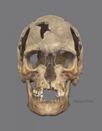
Forensic artist Hayley Fisher has made a facial reconstruction of what the man may have looked like from the remains of the skull. He looks a little young for a 50-year-old pirate/criminal. Needs more weather beating.

Ginger Churchill goes to hell on Austrian church ceiling

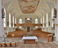
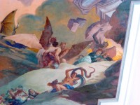
On the ceiling of the Three Kings’ church in Hittisau, western Austria, is a large scale painting of The Last Judgement. That is not unusual. What is unusual is that one of the figures depicted going to hell is Winston Churchill in a red wig.

The Roman Catholic parish church of Hittisau was built in 1842, funded by a bequest from priest Josef Schnell who stipulated in his will that construction on the new church would have to begin within five years of his death or no dice. Schnell died in 1838, so they just made it in under the wire. The Three Kings’ church was completed in 1845. In 1850, artist Josef Bucher made three altarpieces to adorn the high altar, but other than that the interior decoration was quite spare.

When Father Josef Maisburger was assigned to the parish church in 1934, he wanted to gussy it up a little. In 1936 he contacted well-known Munich artist Waldemar Kolmsperger the Younger to explore the idea of painting a mural on the ceiling. Waldemar Kolmsperger the Younger followed in the footsteps of his father Waldemar Kolmsperger the Elder (1852-1945) whose Neo-Baroque extravaganzas earned him the title of the “last Baroque painter.” The younger Kolmsperger specialized in church decoration, a signature of the elder, and worked in a style reminiscent of the Baroque flourishes that had made his father famous. A professor of the Munich Academy of Fine Arts, the son of a famous artist and a leading church painter in his own time, Kolmsperger the Younger didn’t come cheap. His final price was too high for a small village church budget, so Maisburger packed his dreams away for a rainy day.

That rainy day came in 1940. Now Austria and Germany were the same country, and it was a country at war. New church mural commissions were few and far between and this time when Maisburger reached out to Kolmsperger, his fee had dropped enough to make him affordable for the Three King’s church. The linked article says Kolmsperger was motivated to accept this small-potatoes gig in a tiny village in rural Austria in part because he feared conscription, but he was born in 1881 and I seriously doubt 60-year-old men were in fear of the draft, not in 1940 at any rate. It was at the end of the war when old men and young boys were dragged into service.

As the Battle of Britian raged in the late summer and fall of 1940, Waldemar Kolmsperger began work on the Apotheosis of Christ in Heaven and Hell. He worked behind a white sheet so people didn’t see the painting until after it was completed in 1941. When the work was finally revealed to the public, the people of Hittisau were horrified to find that Kolmsperger had not only flipped the entire village the bird, but he had pulled a Dante and put a living political figure in hell.

Hans Weiss said: “The fresco did not include on one side heaven and hell on the other, apparently the artist disliked the area so much, he decided to paint two hells.

“Secondly, there was quite noticeably a picture of Winston Churchill right at the heart of the hill where Judgement Day was being carried out, showing him carrying a huge bag of money which represented his ill-gotten gains for his treacherous behaviour, and containing the writing “100,000 pounds”.

“Despite the protests of locals the artist refused to change it, and there was a huge row that went right up to the bishop. Locals were convinced that once bomber command found out about the insult, they would deliberately target the church in order to eradicate it.

“The Bishop apparently agreed and he eventually ordered the artist to disguise Churchill by giving him a red wig, and to change the word pounds to gold.”

So Kolmsperger grudgingly made the changes, plopping a ginger Moe wig on Churchill’s head so instead of looking like a bomb-baiting Winston Churchill, he looked like a bomb-baiting Winston Churchill in a ginger Moe wig. He wasn’t happy about it, though, and apparently plotted revenge. His plan was to add a few of the locals to the hellscape, and since he’d already put a couple of topless ladies in the mural who were eerily similar to women from the village who Kolmsperger was suspected of having bedded, nobody put it past him. The villagers are said to have chased him out of town before he could make his final alteration.

Ivan the Terrible-era weapons cache found

Archaeologists excavating the site of future highway construction near Zvenigorod, a medieval town in the Moscow Oblast about 40 miles west of the capital, have unearthed a cache of weapons from the era of Ivan the Terrible (r. 1547-1584). The arsenal was discovered alongside the remains of the 16th century village of Ignatievskoe. The team unearthed about 60 buildings from the village. One of them had burned down in the mid-16th century but its basement survived remarkably unscathed. It’s in the underground timber-lined storage room that archaeologists discovered what they believe was the private arsenal of one of Ivan the Terrible’s elite cadre of knights.

They found helmets stored in leather boxes, kolchugs (a kind of cuirass), sections of military sabres, belts, and arrows and more. It seems possible that this was a cache of weapons for a military expedition, stored in special boxes, including even sections of camp tents and billy cans. This warlike inventory, along with the status of its owner, probably indicated the existence of a standing army of troops in readiness, who were armed, billeted and fed at the cost of members of the nobility as part of their responsibility as courtiers.

The spherical helmets with the pointed spikes decorated with gold and silver fittings are particularly splendid examples. There are similar ones in major Russian museums today, but these are the only ones ever found still inside their leather storage boxes with their fabric linings and ear-pieces intact.

The identity of the cache’s owner is unknown, but Ignatievskoe which was the home of the Dobrynins, an important boyar family who had at least one son among the oprichniki, a personal guard hand-picked by Ivan to police an area that was under his exclusive control. Ivan had demanded the creation of this new region as a condition of his return to Moscow after his sudden December 1564 departure. Distrustful of many nobles and clergy who he was certain were a pack of treasonous thieves, Ivan had left Moscow and sent a letter announcing his abdication. The boyar court was terrified that Moscow would fall into violence and chaos without Ivan’s leadership, so they agreed to all of his terms. Ivan decreed the creation of the oprichnina, a territory that he thought was rife with rebellious nobles (and, coincidentally of course, valuable industry), over which he had absolute power, including the power to execute anyone he wanted no matter how aristocratic without having to justify himself to the boyar council. Even family wasn’t exempt. Ivan’s cousin Vladimir of Staritsa, the grandson and nephew of Tsars, was one of the nobles who was executed and had his property confiscated under the oprichnina.

His army of a thousand men swore loyalty to him alone. Famed for their black horses and ruthless application of Ivan’s notion of justice, the oprichniki killed thousands, noble and peasant. Their unchecked violence culminated in the 1570 Massacre of Novgorod when more than 1500 nobles and uncounted numbers of commoners were tortured, killed or kicked out of the city to die from exposure and starvation. The massacre turned the tide against the oprichniki so decisively that Ivan was compelled to disband it in 1572.

Ignatievskoe was in the middle of several towns in the Moscow Oblast added to the oprichnina. It’s possible the arsenal was intended to arm Ivan’s terrible black-horsed guard in the performance of their brutal duties. It’s also possible that it was meant for other campaigns as the late 16th century was plagued by incursions from the Polish–Lithuanian Commonwealth as well as internal conflict.

“This gives us a much better idea how a Russian noble would have prepared for setting out on a military campaign—each nobleman would have had his own arsenal in readiness. This excavation enables us to ‘see’ for the first time the preparations made by the noblemen who made up the officer corps elite of the Russian army at the time of the flowering of Muscovy as a Russian state,” Mr. Alexeyev remarked.